
April 13, 1997
We planned our early spring ascent of 9,495 foot Mt. McLoughlin for April 12th and 13th, 1997. Located in the southern Oregon Cascades east of Medford, Mcloughlin's remote summit would prove an elusive goal this particular weekend. We departed from Eugene for the four hour drive early Saturday. Fair weather had been forecast through Sunday evening, but ominous misty showers sprayed the windshield occasionally as we headed south on I-5.
Passing through Medford, we turned east up the highway leading toward Klamath Falls. Normally McLoughlin would loom large above the horizon from there, but light clouds obscured the foothills of the Cascades. We drove up to the Mt. McLoughlin trail head near Fish Lake Resort and were geared up and started hiking from the 5023 foot snow park area at 11:30 a.m. under a partly sunny sky. Our gear consisted of a full winter camping inventory, plus winter climbing gear such as ice axes, crampons, snow shoes and trekking poles.
The Cascades backcountry in winter is easy to get lost in. We started by following the local section of the Pacific Crest Trail, but soon all signs of the trail vanish under five feet of terrain altering snow drifts. At that point our goal was to proceed north easterly up and around McLoughlin's base until arriving approximately at the beginnings of the east summit ridge. We hoped to establish a base camp somewhere over 7000 feet to facilitate a summit bid Sunday morning.
By following a compass setting taken from our topographical map and reading the general lie of the land we were traversing, we climbed without reference points for several hours through the deep snow- blanketed forest, and finally at 4:00 p.m. arrived at a snowy flat spot in the ridge line which offered the first good view of the summit ridge. We had ascended to 7200 feet and were positioned exactly as planned. As we setup camp, the clouds danced across the summit which towered 2000 feet above camp.
Tom created another one of his wilderness culinary delights with mediterranean spiced vegetables and a pasta dish called coos coos. Sitting in our make shift kitchen area literally carved with a snow shoe from the frozen ridge like an inverse igloo, we watched the skies clear as twilight glowed on the summit above. All was silent and calm. The celestial inventory in the sky glowed with increased intensity through the thin clear night air, with comet Hale-Bopp appearing directly over the summit to our west. The moon was a crescent to the south, Mars shined ruddy red, and Venus glowed particularly blue-white. It was a natural light show with few rivals.
Our plan was to get up at dawn and judge the conditions for climbing. At 6:00 a.m. I got up and tried to read the weather conditions. It seemed heavily overcast, but being slightly before sunrise, it was difficult to tell how thick the clouds were. I returned to the warmth of the tent to let the sun come up before making a decision. By 8:00 we were up having breakfast and gearing up for a climb. The summit had been visible when we got out of the tent, but the clouds above continued to flow by, obscuring it in their embrace.
Finally we started up. We were carrying
light packs with all our cold weather gear, and we had put on our crampons.
We began the kick step toe pointing up the crusted snowy ridge. The eastern
ridge is shaped by a tremendous collapsed bowl on the northern face of McLoughlin.
This cirque's northern wall falls off a thousand feet as you near the summit.
The wind began to pick up almost immediately as we moved along the ridge, and
then we noticed for the first time a few tiny flakes of snow blowing past. It
didn't seem bad, and visibility both up and down the mountain was still excellent,
so we climbed on along the steepening summit ridge, taking care to stay safely
in from the corniced northern precipice. 
Climbing on, the terrain was wonderfully pristine. The scenery along the way captured our attention with wind- sculpted snow fields and ancient contorted pines somehow surviving on the frozen slopes. The snow was falling heavier then, but still visibility remained good in all directions, so we continued on hoping for clearing. We stopped to adjust our gear, putting on shells, over mitts, and hoods. The climbing was cold and miserable, but something sparked up to continue on.
Above 8500 feet the snow was falling thicker, and the wind was making movement and communication more difficult. We decided to start reassessing to continue on or ont every fifteen minutes from that point. We could see the first ridge point which lies only a few hundred feet below the summit, so we headed for that goal. I have climbed technically for several years, but this was the most serious climbing I have ever done in terms of using my technical gear under extreme weather conditions. As we approached our interim goal, I nervously looked back to notice the path of our foot prints was vanishing in the driven wind. I could not see far down slope for that matter.
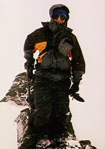
Standing there on the ridge at 9200 feet, we could not see the summit only a few hundred yards and three hundred feet above us. The wind was blasting us with heavy snow at forty miles per hour, and we had to shout to each other to be heard over the howling gale. The storm's clouds had enveloped us. From the first random ice crystals that had fallen, to a full scale blizzard had taken less than two hours to develop. We were in a bad position with visibility dropping fast. We ruled out going further since we could not see the summit or the extreme cliffs on the north side of the ridge line. However, we still had to get down.
I had never been at such an altitude in such horrible conditions, but I had trained to survive them. We took a couple of pictures and turned backward down the mountain. The storm was dumping inches of wet snow on us, and our shells were close to being soaked. Moving fast was critical, so I lead the way down following the terrain of the ridge from recollection of formations I had seen along the way. On occasion I glimpsed the remnant of a foot print, but they seemed to vanish under foot as snow washed across the slope driven in clouds. The mist and the snow combined to white out the slopes above and below us.
 We continued to grope our way toward camp, descending safely down
almost 2000 feet of obscured alpine ridge line back to our camp. The first real
danger had been negated, but our next goal was to get off the mountain and out
of the wilderness before the sudden spring snow storm erased our trail running
into the wilderness. This trail was now suddenly our only clear link to safety
at the trail head. Soaking wet in the heavy snow, breaking camp was made more
difficult, but the urgency of moving fast kept us motivated. Hypothermia was
a real danger to us in such cold, tired and wet conditions.
We continued to grope our way toward camp, descending safely down
almost 2000 feet of obscured alpine ridge line back to our camp. The first real
danger had been negated, but our next goal was to get off the mountain and out
of the wilderness before the sudden spring snow storm erased our trail running
into the wilderness. This trail was now suddenly our only clear link to safety
at the trail head. Soaking wet in the heavy snow, breaking camp was made more
difficult, but the urgency of moving fast kept us motivated. Hypothermia was
a real danger to us in such cold, tired and wet conditions.
At last we had stuffed our packs and broken down the tent. Strapping on our snow shoes we started the march back out of the wilderness in the heavy snow. It as a magical trek through a winter fantasy. There was never a more still alpine scene, snow flakes covering everything in soft white blanket. We floated down the slopes following our vanishing prints, but as we covered miles the fatigue increased, and the pleasant snow shoeing became a painful monotony as we took each new step. Still the miles passed and our descent soon took us below the snow line, and then the rain got its chance at us.
Our gear was soaked and heavy, and our bodies were cold, wet and pained with fatigue. The weight of my pack felt amplified to twice its normal feel. Then there was a disaster. We suddenly realized in our soaked trance that we had somehow lost our foot prints along the Pacific Crest Trail, and now we were off for some unknown time on another trail system. We stopped to consider our choices. Back tracking who knows how far, or reconnoitering our position and heading out on a compass bearing were our only choices, and we had to act fast as we chilled down.
We determined to bush whack due south which should take us directly to the highway, even if it wasn't exactly at the trail head. We struck off heading south and finally heard the reassuring sound of cars on the road in the distance. We tramped on and finally came to the ribbon of civilization most people only think of as a highway. We were only a half mile down the road from the parking area, so we dumped our backs in the trees and hiked back to get our vehicle. Picking up the gear, we drove a mile down the highway eat dinner and camp at Fish Lake resort area.
This was certainly a demonstration of how swiftly weather conditions can change in the Cascades, but it was also a learning experience for us. It validated our climbing and route finding skills and our ability to effectively utilize our equipment. We were pushed to an extreme edge but made the right decisions which got us out of a dangerous situation. I do want to return to McLoughlin some sunny day this summer, but for now the vague outlines of its volcanic ice crested summit will have to suffice in memories of this adventure.
Cascades Tour | Virtual Climbs | Live Cameras | Climb the Web | Top Pics | Cascadia | Yama no Tao | Climb Smart | Home Page
Copyright © 2000 R.A. Halterman - All Rights Reserved