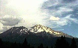
Early
summer is a chance to climb some of the most beautiful volcanic peaks in the
Pacific Northwest Cascades. When July rolled in with warm, sunny days it was
time for another adventure to one of the southern most Cascades summits, 14,162
foot Mt. Shasta. I grew up almost in the shadow of Shasta's snowy peak, and
its presence loomed on the horizon whenever I looked south, but I never had
an opportunity to climb there. Last year however I felt the call of this mysterious
place pull strongly at me, and I made my first climb of the peak. Now, again
this summer I planned a second bid at Shasta's summit.
The trip always starts
with articulate planning of equipment, food, and schedules. There is no margin
for having less equipment than is needed for a high alpine assault, nor would
you want to pack too much weight on such a strenuous climb gaining 7,000 feet.
Based on experience my inventory would prove to meet the needs of this particular
climb. After my clothing, tent, food, stove, sleeping bag, ice axes and crampons
were stuffed in or strapped on my pack, I was carrying fifty pounds of equipment.
"Luckily I own all this light weight gear," I thought to myself with a chuckle
as I weighed in.
I got out on the road at
8:00 a.m. and made the drive to Mt. Shasta City in about four hours. As you
approach Shasta from any direction the mountain towers above every local landmark
by almost 10,000 feet. Drawing closer it stands above you, forcing a feeling
of insignificance on your ego. We cannot compare ourselves to this ancient giant.
By the time you pull off the freeway and look up from anywhere in town, you
wonder if you really have what it will take inside to climb so high into the
heavens.
As I headed through town
the last outpost on the way to the trail head is The House of Ski, and the sign
out front caught my attention causing me to pull in. The words "Climbers Passes
Available Here" made me realize this wonderful mountain was moving into the
Twenty-first Century, to the tune of $15.00 per climber ascending over 10,000
feet. I picked up my pass good for three days and continued on up the ten mile
drive to the Bunny Flat trail head feeling licensed to climb.
The trail head area at
Bunny Flat was not too crowded thankfully since it was only Thursday. I took
my time to eat some lunch while I assembled my pack, and finally started up
the trail at 1:00 p.m. in hot sunny weather. It took less than an hour to climb
up the trail through the thinning forest up to Horse Camp located at the 8,000
foot level of timberline. A small gathering of hikers and climbers were around
as I chatted with some German tourists who had questions about my plans. I paused
only a few minutes to top off my water bottles from a spring and continued onto
Olberman's Causeway.
This rocky "sidewalk" took
Mac Olberman, the original caretaker of the Sierra Club cabin located at Horse
Camp ten years to construct, but it was a feat worthy of comparison to much
larger architectural efforts. Volcanic stones of every shape were fitted together
in complete natural poise with the environment to form a stairway up through
the delicate sub-alpine zone, protecting native flora from being trampled by
thousands of climbers annually. The Causeway leads up to become a climbers trail
when the path changes to steeper rock and scree climbing.
Over the course of three
hours I climbed first the rocky terraces and the "quick scree" trails until
finally at about 9,000 feet I came to the border beyond which everything would
be snow climbing. The few scattered groups of climbers ahead of me were moving
very slowly on the steepening snow, but I forged on at my pack horse pace under
my full load and eventually passed everyone on the snow fields leading up to
Helen Lake. In the soft snow I used only my ice axe to steady my placement on
the slope, not feeling the need for crampons yet. I would have plenty of crampon
work in the morning.
The climbing wasn't too
painful, and four hours after leaving the parking area I arrived at the 10,400
foot ledge known as Helen Lake. As usual there was no lake, nor pool, nor any
sign of standing water. Instead there was a rise of snow possibly eight feet
deep pitted unevenly from many snow camp tent platforms melting and refreezing
into a cratered, contorted, almost lunar landscape. I suppose I should say "Martian"
landscape to be politically correct now days. At the extreme edge of the snow
field's grasp along the curving outer edge this natural "shelf" was an area
of sand and gravel platforms surrounded by rock wind barriers that generations
of climbers had piled up. These areas allowed perhaps a dozen tents to be erected,
each with a fabulous view both up and down the mountain. I claimed one that
seemed custom ordered to fit my North Face tent, and in no time I had setup
camp and could relax before the morning climb. The weather was cool but the
strong Californian sun made it comfortable in just a jacket.
Then as if from no where
Shasta displayed its propensity to change the weather like we change our minds.
From over Casaval Ridge rolled a think billowing cloud which in seconds obscured
the summit from the Red Banks and above. The rest of the evening passed the
same as the mountain would clear up and then quickly be shrouded again in blankets
of white mist above 12,000 feet. There was nothing to be done than go to sleep
and check the weather conditions early in the morning. So after a dreamy evening
watching the sun set and the cloud caps dancing with the summit I retired for
what sleep I could gain before the morning assault.
I awoke and wondered if
my watch alarm was functioning properly. Turning on my flash light I made out
through squinting eyes that it was 3:45. Close enough for government standards,
I unzipped the tent and crawled out far enough to look around. I have described
many stunning natural scenes before, but this view was perhaps more breathtaking
than any I've ever seen. The vaulted dome of the sky was a delicate velvet blue
shot full of twinkling stars that burned with an intensity unequalled in my
experience. Looking up the mountain the light from the last quarter moon directly
over head illuminated the mountain in crisp, still clear air. Looking down the
lights from Mt. Shasta City twinkled with more colors but not so vividly as
the stars. It didn't even feel very cold, which is always a good start on a
climb. Conditions were perfect! I launched into preparations to go.
By 5:00 a.m. I started
climbing across the cratered snow field replete in my Goretex shell, gaiters,
crampons and ice axe at the ready. My legs still felt rubbery and fatigued from
the previous days work, and the air seemed thin already. I moved intentionally
slow, but it seemed so slow it was pathetic. I was feeling that everyone would
pass me, but as the pale pink glow of pre-dawn brought the details of the slope
to light, I saw just a few climbers above me, and quite a few below far away
just leaving camp. I pressed on moving up the steeper slopes grinding out my
too slow pace traversing back and forth at an angle to the slope. Slowly, oh
so slowly I drew closer to the Red Banks contemplating how good it would feel
to have Avalanche Gulch out of the way, trying not to long for anything further
than one crampon placement higher in the snow, one ice axe planted in the slope
above.
After passing the rock
field known as "The Heart" on the right, I eventually gained the Red Banks at
the right hand end near Thumb Rock and stepped across onto the other side to
determine if a bergschrund had opened between the Red Banks headwall and the
perpetually moving Konwakiton Glacier. As I crossed the ridge crest I was for
the first time blasted by direct sun at 12,500 feet. The scene was suddenly
terribly bright but bitter cold from a wind thrashing across the ridge line.
The snow wall was intact allowing me to climb directly across to the ridge ascending
above the Banks. I paused in a place sheltered from the wind to dully eat a
snack and put on a polartec jacket under my shell for more insulation. I also
put on my mitts to protect my fingers from the cold wind. It was too cold to
sit around and I could feel the thin air robbing my appetite, so I quickly got
up and moved on up the ridge which included climbing up frozen pumice mud. Crampons
bite well into this concoction offering good footing that eventually turned
back into frozen snow and ice as I neared the foot of Misery Hill.
Anyone who knows something
about climbing Mt. Shasta probably has a story to tell about Misery Hill. Its
not technically challenging, its just a place to learn about your own inner
patience and determination. This steep slope rises like a huge cone that climbs
about 1,000 feet to the rolling summit plateau. So featureless is this formation,
and so leaden your steps as you ascend to nearly 14,000 feet, that climbers
move as if in slow motion. The time warp is best forgotten about on this pitch
of the climb, so I didn't bother looking at my watch. Time for me was marked
by just one appointment, and that was cresting the top of Misery Hill. At the
top of the rise I gained a path cut into a steep snow slope that fell off for
hundreds of feet. I traversed the trail and arrived at a small outpost formed
by natural rock thrusting through the snow that marked the top of the infamous
Hill.
Droping my pack, I sat
down like a dead weight on one of the rocks. Before me was just a couple hundred
yards of gently rolling plateau and the summit pinnacle cone a few hundred feet
higher. I saw just two climbers far off near the cone and no one behind me.
Just resting for a moment felt vital. Even though my goal was only hundreds
of feet away, my fatigue was exhausting. I glanced over and noticed a small
memorial plaque cemented to a smooth vertical rock face. I thought just about
every climber passing this way must be close to needing a memorial plaque of
their own. After just a few minutes I knew it would get no better so I put my
pack on again and moved off up the gentle slopes leading to the pinnacle.
When I arrived at the final
obstacle, a steep cone composed of boulder fields, scree, and ice, the foot
prints in the snow vanished going up across a slope strewn with every size rock
from several feet in diameter on down, some cemented loosely into a conglomerate
by ice. The vaguest hint of trail plus my recollection from last year's climb
lead me scrambling upward around the cone, steel crampons scraping loudly across
rock sending showers of sparks dancing, then finding purchase in a chunk of
ice. The final ascent lead up across the boulders onto more frozen pumice, then
back onto ice. Finally there appeared before me a notch in the path leading
onto solid core rock. I knew this formation marked the summit. I clawed across
the rocky threshold and found the summit bathed in sunlight with no wind and
an immense view in all directions from clear skies. It was 10:00 a.m., about
brunch time for some people, yet there I was over 14,000 feet looking out across
northern California and southern Oregon as if from heaven. There were just two
other climbers with me there. We exchanged greetings and took turns signing
the summit register. I recorded some special notes for posterity and sat back
in the sun to eat what I felt like, drink as much as I could, and rest. From
my vantage point I could look down 10,000 feet into the low foothills on the
southeast slopes. Shasta's summit offers a truly awesome view point.
However, as the minutes
passed a white cloud erupted again as if from no where far down the mountain
crossing Casaval Ridge and obscuring the slopes of Avalanche Gulch from view.
One never knows what the ancient spirits of Shasta has in mind, so after a half
hour of bliss I stood up once again on wobbly legs and started back down toward
camp. Descending is always more dangerous than climbing in respect to fatigue
and impatience causing a mistaken step. Thus I took each step down that boulder
pocked cone with articulate foot placements. At the bottom of the cone I came
upon a climber named Kevin who had his camp next to mine. We exchanged brief
greetings and I continued on my way letting the gravity well work in my favor,
but keeping my steps throttled back to a controlled pace. Down Misery Hill and
the ridge below to the Red Banks I descended until I came upon the first steep
icy chimney marking immediate passage down into the Gulch.
I started down thinking
it would be a safe route and quickly realized I was in some trouble. The steep
walls of rough welded pumice kept this chute in constant shade, and the surface
had become a hard, glazed sheet of ice that defied my efforts at planting the
point of my ice axe and which my crampons could do little to gain purchase without
turning around and down climbing, but my second ice tool was strapped to my
pack. Gingerly I stabilized my position by spreading my legs wide and planting
my spikes into the walls of the narrow chimney. I could either take an uncontrolled
gliassade down the one hundred foot chute hoping to maintain control, or climb
back out of the icy tunnel. I decided climbing back out and traversing to a
less dangerous spot was warranted. In other words, I was scared to death about
the uncontrolled slide. I managed to work my second ice axe out and once I had
a tool in each hand it was easy work ascending back up the chimney to a point
I could traverse to lower exits out of the Red Banks.
Below me Avalanche Gulch
was being swept by the afternoon cloud banks again. Although I knew my camp
was just 2,500 feet below me, sometimes the clouds filled the entire cirque
making it impossible to see just where to go. Arriving at the bottom of those
imposing red cliffs, I traversed back to the apparent glissade run and reconfigured
my gear for a slide. I tightened my gaiters and took off my crampons before
getting into "the tube". The second I sat down I was sliding fast down the hill
eating up the elevation as I plummeted toward Helen Lake. I dug my ice axe in
behind me and leaned back with all my weight to slow myself from becoming an
uncontrolled bullet in that luge run. In just minutes I lost about 2,000 feet
of elevation and was left with just a few minutes walking distance back to my
tent. It was indeed a wonderful sight to come back to the relative comfort of
my little home nested on that ridge at 10,000 feet.
That afternoon was spent
drying my gear and clothes, resting, eating, drinking all the water I could
hold, and swapping stories with other summiters. There were of course quite
a few who had tried but failed to attain Shasta's summit that day, and among
them were a few who's dejected countenances showed the pain which the mountain
had subjected them to. I observed them and realized the truth that a mountain
of Shasta's stature names its own price which those who would challenge its
heights must pay. This is Mt. Shasta's own Summit Pass. Fifteen dollars is a
far better bargain in comparison to this fee. Finally as evening wore on the
cloud caps once again enveloped the summit above, pulling the curtain on another
day's performance for this mystical giant. Near sunset the clouds opened up
with rain showers and then hail accompanied by rolling thunder. I curled up
comfortably in my cocoon and slept through the night.
In the morning I looked
out of my tent once more and was surprised to see the sky was again perfectly
clear and the summit brilliantly illuminated above us. Shasta's quickly changing
weather patterns never cease to amaze me. This was a morning for a leisurely
breakfast of ramen noodles cooked on my stove along with hot tea. I methodically
broke down my camp and secured all my gear back into my pack. Finally with my
neighbor Kevin we descended back down the frozen snow fields and eventually
back onto scree, then rock, then finally back onto Olberman's amazing Causeway.
Once I was back down to Bunny Flat and dumping my gear at my vehicle, I looked
up the mountain and noticed the formation of another lenticular cloud cap dancing
about Shasta's summit. It was a wonderful, chaotic boiling of nature's forces
moving around Shasta's pillar of stone that thrust so far into the heavens.
It struck me as no coincidence that native peoples revered Shasta as a place
of great spirituality. Even to me in this modern age I was moved by the same
spirits of nature that our ancestors recognized.

 Early
summer is a chance to climb some of the most beautiful volcanic peaks in the
Pacific Northwest Cascades. When July rolled in with warm, sunny days it was
time for another adventure to one of the southern most Cascades summits, 14,162
foot Mt. Shasta. I grew up almost in the shadow of Shasta's snowy peak, and
its presence loomed on the horizon whenever I looked south, but I never had
an opportunity to climb there. Last year however I felt the call of this mysterious
place pull strongly at me, and I made my first climb of the peak. Now, again
this summer I planned a second bid at Shasta's summit.
Early
summer is a chance to climb some of the most beautiful volcanic peaks in the
Pacific Northwest Cascades. When July rolled in with warm, sunny days it was
time for another adventure to one of the southern most Cascades summits, 14,162
foot Mt. Shasta. I grew up almost in the shadow of Shasta's snowy peak, and
its presence loomed on the horizon whenever I looked south, but I never had
an opportunity to climb there. Last year however I felt the call of this mysterious
place pull strongly at me, and I made my first climb of the peak. Now, again
this summer I planned a second bid at Shasta's summit.