The Mount Kitanglad Range belongs to the volcanic Lanao-Bukidnon Highland and
covers most of the northern half of Central Mindanao. It has an elevation up to
2,938 meters above sea level, dominating the Bukidnon plateau. The Kitanglad
mountain range is composed of numerous peaks, the more prominent ones are Mt.
Kitanglad, Mt. Kaatuan, Mt. Maagnaw and Mt. Dulang-Dulang. This is one of the
confusing mountains in the country in terms of stature. It was once measures as
2,385 meters above sea level but recent claims contest that the mountain’s
highest peak, Mt. Dulang Dulang measures 2,938 meters above sea level, thereby
making it the country’s second highest peak after Mt. Apo relegating Mt. Pulag
to the third place. Though no official proclamations proves this and Pulag is
still called the country’s second highest. Kitanglad mountain range is a part of
the Kitanglad National Park and is situated in North Central Bukidnon. It has an
area of 31,297 hectares composed of more than a dozen mountain peaks. It is home
to a host of rare bird species like the serpent eagle, the red harrier, the
Brahmin kite and the Philippine sparrow hawk to name a few.
Mt. Kitanglad towers more than 2,500
meters which offers a challenge to mountain climbers. To reach it’s summit, one
has to scale its ranges for five hours passing through flora and fauna of a
genuine virgin forest. At the base is Lawan Dalawangan, which is the home of the
Philippine Eagle. The Kitanglad mountain range which dominates the north-central
portion of the Bukidnon Plateau plays a vital role in the socio-economic
development of North and Central Mindanao. Aside from being the homeland of
indigenous cultural communities of Bukidnon, it is also a major watershed
providing water for power generation, irrigation, and domestic use for the
provinces of Bukidnon and Misamis Oriental.
The place is occupied by 8 municipalities
of Bukidnon namely Talakag (4,945 ha), Baungon (3,157 ha), Libona (6,196 ha),
Fortich (595 ha), Sumilao (3,532 ha), Malaybalay (2,317 ha), Lantapan (7,912
ha), and Impasug-ong (1,985 ha). Mount Kitanglad Range, covers an estimated area
of about 30,642.0 hectares, of which 82% is secondary forest, 5% brushland, 12%
grassland areas while the remaining 1% constitute agricultural/open and bare
soil areas. Its buffer zone covers an area of 14,480.0 hectares. The climate of
Mt. Kitanglad falls under Type III of the Modified Corona's Classification. This
is characterized by a short dry season lasting from one to three months and with
no pronounced maximum rain period. Temperature ranges from 22.7 C during January
to 24.6 C during June. The area receives the highest amount of rainfall during
the month of June, while the driest period is in the month of March. Relative
humidity varies from 71% in May to 86% in September. The area is virtually
cloud-covered throughout the year. Mt. Kitanglad Range forms the headwater
catchment area of several major river systems draining North and Central
Mindanao. Among these are the Cagayan, Tagoloan, and Pulangi Rivers.
WHEN AND HOW TO GO
 It’s safe to scale the mountain all year round. Access to the Province of
Bukidnon is through Cagayan de Oro City. Daily plane flights from Manila and
Cebu are available. From Cagayan de Oro, the park can be reached by regular
public transport (jeepneys and buses) plying the Cagayan-Bukidnon routes. Three
existing trails lead to the mountain summit. The first trail is located at
Intavas, La Fortuna, Impasug-ong town, the second trail is at Barangay Lupiagan,
Municipality of Sumilao, and the third starts at Bol-ogan, Songco and Kaatuan,
Lantapan, Bukidnon.
It’s safe to scale the mountain all year round. Access to the Province of
Bukidnon is through Cagayan de Oro City. Daily plane flights from Manila and
Cebu are available. From Cagayan de Oro, the park can be reached by regular
public transport (jeepneys and buses) plying the Cagayan-Bukidnon routes. Three
existing trails lead to the mountain summit. The first trail is located at
Intavas, La Fortuna, Impasug-ong town, the second trail is at Barangay Lupiagan,
Municipality of Sumilao, and the third starts at Bol-ogan, Songco and Kaatuan,
Lantapan, Bukidnon.
POINTS OF INTEREST
• Del Monte Philippines, Inc.
This plantation is located in Manolo Fortich, Libona, Impasug-ong and Sumilao.
It is considered to be the biggest pineapple plantation in the Far East. It
has vast tracks of land planted to pineapple. It also has a famous world-class
18 hole golf course.
• Mangima Canyon
Located in Manolo Fortich dubbed as the Kennon Road of the South. The Zigzag
road of mangima canyon stuns any visitor who visit the place. It is naturally
a scenic spot that makes anybody wonder at creation and leads him to believe
there is a supreme being behind all these naturally wonderful spots on earth.
• Panyak Cave
Found in the Palao-pao Mountains of Sumilao, Bukidnon, is a fifteen minute
ride and an hour and so minutes walk from Sayre Highway in Kisolon. This huge
cave contains stalagmites and stalactites.
• Atugan New Bridge
It is said to be the highest bridge in the country. Constructed with the
latest trends in strucural engineering. Located at Sayre Highway, Municipality
of Impasug-ong.
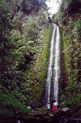
• Impalutao Reforestation Project
It is along the Sayre Highway in Impalutao, Impasug-ong. It offers nature
lovers, beautiful forest and crystal clear waterfalls, the Dila and Gantungoan
Falls.
• Bukidnon Forest Inc.
See a man-made miracle happen before your eyes. See the 36,000 hectares
reforestation project of the Philippines assisted by New Zealand.
• Kaamulan Park
Located at the back of the Provincial Capitol, the area is best used for
camping or just pure lazying around. It has also been the site for provincial
fairs, foremost of which is the "KAAMULAN". The park in its natural setting
abounds in pine trees.
• Nasuli Springs
Located twenty kilometers from Malaybalay, Nasuli Springs offer the nature
enthusiast, cool, clear, waters ideal for driving and swimming.
• Apo Lake
Located in Barangay Guinoyoran, Valencia. This twenty five hectare lake is
surrounded by mountains. It is an ideal place for boating and fishing.
• MGM Resort
Located in Dologon, Maramag, the resort is popular for swimming and
relaxation.
• Luan-Luan Spring and Swimming Pool
Located within the Poblacion, Quezon. It is a place wherein several springs
abound and flow the whole year round. It is popular for swimming.
• Ver Overview
Ver Overview is a high point located at Sitio Kipolot, Palacapao, Quezon. The
area is properly landscaped where one could feel the fresh air whole day long.
• Pinamaloy Lake
Serene and tranquil, can be seen in the highway from Don Carlos, Bukidnon. It
is often used as picnic area and fishing ground.
• Napalit Lake
The 36 hectares lake, in Pigtauranan, Pangantucan, is at the foot of the
Kalatungan mountains. It stands out because of its twenty four floating islets
of varying sizes, the biggest of which is 50 ft. These islets float around the
lake parallel to the direction of the wind.
Mt. Lara is also located within the Kitanglad range and is were the first
original "canopy walk" is located.
SUGGESTED ITINERARY
DAY 1