
Chaco Canyon, for all its beauty, seems a very strange place for the Anasazi to thrive. This is desert, with very cold winters, short growing seasons, and only 6 to 7 inches of precipitation a year. (Semi-Arid) Yet a thousand years ago, this place was the center of Anasazi life. These people farmed, and built great masonry towns that connected with other towns over a far-reaching network of roads. The Anasazi of Chaco Canyon were so far advanced, their ruins are compareable to the Aztecs of Mexico. (keep in mind the time line...These years were the Dark Ages in Europe)
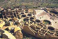
The cultural growth of the Anasazi here, began in the early 900's A.D. It is seen most clearly in the architecture. They started building on a much larger scale. The rooms are much larger, and they started building multi-storied structures. The Large Pueblos are... Pueblo Bonito, Chetro Ketl, Una Vida, Pe�asco Blanco, Hungo Pavi, and Kin Bineola. All of these Pueblos were started at this time. There was to eventually be 75 outlying pueblos. All of them to be connected to Chaco by a highly developed road system.

By AD 1000 Chaco was the political and economic center of the Chaco Plateau. There may have been as many as 5,000 persons living in some 400 settlements in and around Chaco.
The vast extent of the ancient Chacoan road system, impresses even veteran archeologists. There are about 400 miles of roads connecting Chaco to more than 75 communities. The longest known road runs 42 miles north toward the pueblos now called Salmon Ruins and Aztec Ruins, near present day Farmington New Mexico. On the north-south roads, villages lay at travel intervals of approximately one day. These roads are not mearly trails. They are the product of engineering and required a great deal of thought . The roads were laid out to be straight, and to go north, with little regard for the terrain. Some of the roads are as much as 30 feet in width. Their construction is basic. On sloping ground, the roadbed was leveled and a rock holding wall was built to retain the fill. Where the roads passed over bare rock, they were often bordered by stone walls or a lining of boulders. But the most striking thing is that all the villages Aztec Ruins, Solomon Ruins, Chaco Canyon and Casas Grandes, are all perfectly aligned on the same meridian number 108. This is most likely by plan rather than by accident.

During Classic times, Chaco was the center of an incredible trading network. Goods were exchanged from within the Anasazi system and were imported and exported with groups as far south as Mexico. Raw turquoise was imported from distant mines and transformed with master craftsmanship into necklaces, bracelets, and pendants. Great quantities of such jewelry have been found here, more than at any other southwestern site. Other evidence of a trading system are the many seashells (often strung into necklaces), copperbells, and the remains of macaws or parrots found here. The two latter items suggest contact with Mexico, perhaps with the ancient Toltecs.
It is thought that the decline of the Anasazi was due to a prolonged drought that plauged the region from 1130 and 1180. Lack of rainfall, and over stressed fields probably led to food shortages. Even the clever irrigation methods of the Anasazi could not overcome prolonged drought. Under these pressures, Chaco Canyon and the entire Anasazi culture began to fall apart. The people began to leave. It is believed that the Anasazi left to go to better regions, leaving behind impressive evidence of their influence over the vast territory of the Colorado Platue. The descendants of this Anasazi are believed to be the Hopi's of Arizona, and the Zunis, Acomas and Pueblos of New Mexico.
Sign My Guestbook
View My Guestbook
![]()


