
This name is a little deceptive since the rocks that give this trail its name were blasted out of the water in 1958. Prior to that time, two rock protrusions in the Seymour Narrows had caused the wreckage of many ships. Some say you can still see a swirl in the water at the point where the original rocks were but I can't say I observed this.
To reach this trail, drive
along the #19 highway north of Campbell River for about 15 km. Watch
for signage. (Right hand side of highway.) The trail is well marked
and there is parking just off the highway at the trail head. It is
4km long (one way). This is not really a wilderness experience. For
much of its length, the trail follows a B.C.Hydro right of way.
You get nice views across Menzies Bay and at one point the trail dips down
to a beach at Nymphe Cove. The trouble is that Menzies Bay
is an active log sort. The mountains across the bay show signs of
recent clear cuts, The bay itself is full of log booms. Barges
make their way up and down the channel.
 |
After you leave Nymphes Cove there is a bit of a climb up to Wilfred Point, a rocky bluff which over looks the narrows towards Quadra and Maud Island.
This is the view at its best.
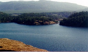 |
What I have carefully avoided in the photo is the mess of power lines and the big metal transmittors that dominate this point.
This is about a 1 1/2 hour to two hour hike each way. It is an exposed site and in bad weather can be pretty daunting. Even after a long dry spell we hit some muddy patches. Generally though and easy trail.
© 2001 vanisle.geo@oocities.com
[Hiking
Trails][Home]
[Geology
of the Island]
