 |
|
|
|
'That I for poor auld
Scotland's sake Some usefu' plan or beuk could make, Or sing a sang at least.' Robert Burns |
|
|
|
|
|
'That I for poor auld
Scotland's sake Some usefu' plan or beuk could make, Or sing a sang at least.' Robert Burns |
'Site by site, line by line, I pieced together a cat's cradle of alignments that could be interpreted as either total delusion on my part, or the abandoned plan of an ancient Trans-Clyde communications network.'
Bell plotted every possible alignment he could find within the city limits. He freely admitted that some alignments could be coincidental, some might be longer than he thought, and others may still lie undetected in the same area. Nevertheless, without any serious selection process involved, the PSAs run straight as a rifle shot through the oldest man-made structures in Glasgow, Bothwell, Carmunock, Crookston, Castlemilk, Dumbarton, Drumchapel, Easterhouse, East Kilbride, Govan, Hamilton, Inchinnan, Kilsyth, Old Kilpatrick, Paisley, Renfrew and Rutherglen. No matter whether it is a castle, church, burial site or habitation, the oldest known site in each of these 17 communities has an alignment passing through it. No amount of 'observer bias' could conjure up this result artificially. This is clear statistical proof that the present layout of Glasgow evolved from a long-forgotten framework of Prehistoric Site Alignments which are accurately sighted onto the surrounding hills.
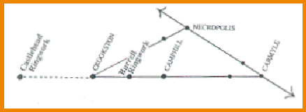
'The four city networks interlock perfectly, forming a larger system which I call the Glasgow Network of Aligned Sites. The source of this system seems to be a triangle with three of the four sightline centres on a single line at the base. I call this feature the Glasgow Triangle'.

Gallowflat Mound, between Camphill and Carmyle on the baseline of the Glasgow
Triangle
'By walking the hills, looking at the sites from different viewpoints and angles, I found a possible sequence for the development of the triangle. First, a PSA surveyed from Duncolm to Tinto as a communication line up the Clyde Valley. On the way it would pass through the Necropolis (1) and Carmyle (2). Next, a shorter Camphill (3) Necropolis (1) line, possibly extended later because it was a suitable direction indicator to the tidal waters of the River Forth.(These two PSAs cross at the Necropolis, which ties in with the rather vague references in old books about travellers in earliest Glasgow walking along the west bank of the Molendinar Burn to join a road which ran along the ridge where the Cathedral now stands.) Third, a PSA surveyed from Crookston (4) to Duncolm. This would not have been a part of the triangle, but it would have established Crookston as a sightline centre. The line could later have been extended in the opposite direction to the De'il's Plantin and Dumdruff. (The next day or 500 years later, who knows?) For most of its length, this alignment runs within a mile or two of the River Cart. A Walls Hill/ Crookston/ Necropolis PSA and another from Crookston to Carmyle complete the triangle.'
 |
|
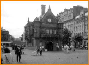
The Travel Information Centre in St. Enoch's Square
is situated right on the Walls Hill/ Crookston Castle/ Necropolis alignment
and stands on the site of a Medieval sanctuary and curative well. A dugout
canoe and a jade axe from the Neolithic era have also been found on this
site.
|
'One Medievalist who taught and specialised in ringworks, mottes,
and early medieval castles in Scotland, thought I had been too selective in
the choice of sites for my maps. Why, for instance, were the ringworks at Camphill
and Crookston represented, while other ringworks were conveniently left out?
I explained that the only other ringwork I knew was the one near the pond in
Pollok Country Park, and as it was nearly 200m from the nearest PSA I naturally
did not include it in my maps.
'But it's not fair if you include the ringworks that suit your purpose and leave
out the ones that don't suit your purpose,' he replied. 'It gives a false picture.'
He then went on to tell me about two other ringworks I was unaware of: one
a semi-circular part-obliterated bank of earth, also in Pollok Country Park
(see D & E 1973), the other, described in the Paisley Burgh Survey of 1980
as 'a postulated Norman ringwork of earth and timber' was on private land. So
in the interests of equal rights for ringworks, I went out for a look at both
sites.
The one at NS 555624, 320m S of the ringwork near the pond in the Park, was
in poor condition. It is known as Pollok Park ringwork but there are two ringworks
in the park, so to avoid confusion it is marked on my map as Burrell ringwork
because of its proximity to the Burrell Collection.
The other ringwork had been landscaped into a rockery at a house in the Castlehead
district of Paisley.
To my amazement, I found that both these ringworks are in perfect alignment
with Camphill and Crookston, on the baseline of the Glasgow Triangle.'
It would be quite ridiculous to suggest that these four ringworks, Castlehead, Crookston, Burrell and Camphill appear on a six mile stretch of PSA by chance. This discovery has brought new problems of interpretation in its wake - does it mean that ringworks were being positioned on Prehistoric Site Alignments up till the 12th Century or does it mean that the sites they were built on are far older than we think they are?
'And what about the ringwork near the pond in Pollok Country Park - the one
that wasn't on my line? A rare stroke of good fortune gave me some information
on this one. In the course of collecting facts for an essay I signed
out four books at the Mitchell Library. For some unaccountable reason the girl
brought me five. The fifth one was called Mary Queen of Scots at Langside,
written by one Ludovic MacLellan Mann in 1918.
On page 100 of this book, on the subject of early dwellings, Mr. Mann had this
to say '... An underground galleried and alcoved house was brought to light
at Crossmyloof. It was situated precisely on a line leading from the prehistoric,
circular, defensive earthwork in Queen's Park to a similar, though smaller,
earthwork in Pollok Wood.'
The underground house was apparently discovered when the properties near the
corner of Minard Rd. and Waverley St. were erected (see Places and Characters
of Old Glasgow, p72). A line drawn from Camphill to the ringwork by the
pond goes straight through that very corner. The strange thing about this alignment
is that MacLellan Mann recorded it in 1918 - seven years before Watkins wrote
The Old Straight Track ...
Ludovic MacLellan Mann - I knew the name. There was a photograph of him at the Cochno stone in R.W.B. Morris' book The Prehistoric Rock of Southern Scotland. I wondered if he too had been an alignment researcher. Back to the libraries I went, and looked up anything Mann had ever written. In one book, Earliest Glasgow, a Temple of the Moon, I found an interesting section titled 'Ancient Land Surveys' on p10. It read as follows:
'The neolithic philosopher and astronomer laid out the Glasgow area on a
plan similar to a clock-face and like a gigantic spider's web, but rigourously
geometrical. Its radii, usually set on a nineteenth divisional system (sub-divided
at times into 38ths and 76ths) dictated the positions, and ran through loci
of prehistoric importance.
These lines were counted anti-clockwise beginning at the south-going
radius which corresponds with the position of the clock-hand which indicates
six o'clock on a modern timepiece.
The 31st radius (on a dial of 38 radii) proceeds from the Cathedral to
St. Enoch's Square and passes in direct line through the centres of several
sacred areas, usually made rectangular, and set cardinally and equidistantly.
This radial line is one of many, but may be here specially noted as it recalls
the story of St. Enoch, a Glasgow notability....'
'Her sanctuary with
its curative well was situated in the present day St. Enoch Square, which has
always been communal property. Through it ran a little stream called the Glasgow
Burn, and the spot was chosen because it lay at a vital locus within
the spider's web.
At this place, and drawn up into the little burn, was found a dug-out
canoe overwhelmed with flood silt. The boat contained among other relics a Neolithic
or Bronze Age polished green-stone axe-blade. It lies within the period 6000
BC to 1000 BC.'
This was heady stuff. I knew about the canoe and stone axe, but the Cathedral/St.
Enoch alignment was new to me. It interested me because at one time I had thought
the Cathedral was a sightline centre. That was before I discovered that the
lines going through it were actually bound for the hilltop cemetery of the Necropolis.
The equal divisions of the landscape seemed far fetched and it didn't seem likely
that an alignment would stop at St. Enoch Square like a No. 5 bus either. Mine
always led to high ground and hilltops. Was it possible MacLellan Mann's line
was longer than he thought it was?
On Bartholemew's 1:20,000 scale City of Glasgow Streetplan, a map so accurate
that the Ordnance Survey grid is incorporated, I held a piece of thread straight,
so that it ran from Crookston Castle ringwork to the Necropolis. It passed through
the northern side of the subway station and narrowly missed Glasgow Cathedral
on the way. It was so close a miss that any sites on the southern part of MacLellan
Mann's line from St. Enoch Square to the Cathedral would be incorporated into
my own line - the much longer Necropolis/Crookston/Walls Hill PSA
- the NW side of the Glasgow Triangle.
Until 1789, the ruins of Bishops Castle stood just outside the Cathedral. Recent
excavations by the Scottish Urban Archaeological Trust have shown that the earliest
structure on this site was an earth and timber ringwork, dated by dendrochronology
(tree-ring dating) to 1191 CE.
So as well as the four ringworks along the Glasgow Triangle baseline, there
is one that was situated very close to the apex (in the region of the Cathedral
and Necropolis photograph on the first page of this
web site).
Back in my schooldays, one of my most treasured possessions was an old copy
of Theodore C.F. Brotchie's 'Some Sylvan Scenes Near Glasgow' (1910 edition).
Because of this, I knew my way round dozens of historical sites in the Glasgow
area that most archaeologists had never heard of. Before Brotchie's day, Hugh
MacDonald had gone over much of the same ground, but his books were not illustrated,
and Brotchie's were. I read both as a schoolboy, but it was really the magic
old Brotchie drawings that worked their spell and started me rambling.
Click
here for a short profile on Brotchie.
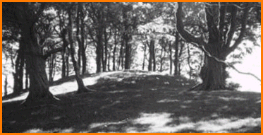
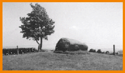
The Deils Plantin mound in direct alignment between Camphill and Dunwan
Hillfort.
It is also aligned to Crookston Castle and Duncolm
My mental picture of the Clyde Valley landscape had changed considerably since
I started archaeo-orienteering. The whole of the Glasgow area had become a giant
game of snakes and ladders in which I was the only player. Rivers served as
snakes, and PSAs served as ladders; it all made perfect sense. Once I got to
know the hills and rivers I understood how people like the Australian aborigines
could memorise routes through vast stretches of land associated with the Dreamtime
wanderings of their ancestors ... When the shape of hills and landscape features
became familiar to me from different angles I, too, could go walkabout.
In field tests at Camphill, Crookston, the Necropolis and Cathkin Braes, I could
indicate the precise direction of dozens of sites that I could not actually
see. Surprisingly, some of the skyline markers I used for this purpose - from
Camphill for instance, could also be used to indicate different sites from Crookston
and the Necropolis.
This marvellous network lay far beyond my own powers of invention. I began to wonder if it had been designed for settlers, rather than travellers. It seemed to have come into being at a time when improved farming methods led to an increase in population, so one of its functions could have been to space settlements out and avoid too many people living off the land in any one area.' (Bell, Glasgow's Secret Geometry, 1993).
The Craw Stane, on a PSA near Eaglesham,
is believed to occupy a Bronze Age burial site.
It is unlikely that the PSAs on this map were all in use
at one time. Re-occupation of popular sites after periods of abandonment seems
more likely. No one person or 'surveyor class' would have designed the network;
it most likely evolved through widespread use over the centuries, then fell
out of fashion when hilltop sites were abandoned.
PSAs were surveyed as single lines, not geometric figures or patterns. Triangles
are the inevitable result of a group of single lines crossing and recrossing
each other. The Glasgow Triangle is a convenient geographical term - it would
not have been known as a triangle in prehistoric times.
It is difficult to assess the width of a PSA. It can be as narrow as a
path between two stones,or as broad as the line of site to a distant hillfort.
It all depends on the viewpoint of the observer.
At present, the only prehistoric alignment in Scotland accepted as having
been deliberately made is the linear cemetery, an alignment of chambered tombs
and cairns in the Kilmartin Valley, Argyllshire. If you transfer PSAs
onto the Ordnance Survey map you will find that the first Glaswegians worked
to just as close a tolerance, but over far greater distances.
PSAs were a means of finding your bearings by using fixed skyline markers. They were not tracks - there was no need to follow them all the way up to the hilltops. Those who use stars for navigation don't have to fly to the heavens to get where they are going either - it's all the same principle.
The reason PSA's are not yet archaeologically acceptable is because orientations between two features known to be unrelated are considered unproven. This is quite logical, but it is also logical to suggest the possibility that the custom of using alignments as landmark systems, territorial boundaries or anything else could have long outlasted the style and function of structures built along its length. If a single site can have multi-phase multi-period use, so can a PSA. Mainstream archaeology has no record of the Glasgow Network whatsoever. It's a fascinating new addition to our heritage and it's all out there awaiting your interpretation.
Back to the Prediction section
We hope you enjoyed your visit to the GNAS site; please feel welcome to :

The story of Harry Bell's research prior to the discovery of the Glasgow Network can be found at
site marketing by www.getmarketingright.co.uk