There are now some 8 million Filipino expats all over the world . . . . .                                   They are becoming conscious of the role they can play in national development . . . . .                                We help them ventilate their ideas and address their concerns . . . . .                                We Ex.P.A.N.D. Worldwide . . . . .                                   JOIN US . . . . .

 
WEDNESDAY January 19, 2005

FRONT PAGE | ABOUT US | FEED BACK | CONTACT US | JOIN US


Here's Great News to our Friends!!!

You may now shop on line with us. Check it out.

Visit MetroBizForums' Web Store now.

PLEASE CLICK HERE

 IN THIS PAGE:

 ►Is Metro Manila sitting on top of a ticking  time-bomb? 

 ►A Doom's Day Scenario... 

 ►The Philippines in the Pacific "Ring of Fire"

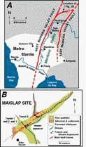
 Multiple large earthquakes in the past 1,500 years on a fault in Metro Manila (A study published in the Bulletin of Seismological Society of America, 2000, vol. 90, p. 73-85)


.


 NEWS ALERT!!!     NEWS ALERT!!!     NEWS ALERT!!!

Is Metro Manila sitting on top of a ticking time-bomb?

.

The shifting of fault lines under the sea, miles away from the shores, caused the recent catastrophe that hit Asia. It caused the sea waters to recede and rise again producing tsunamis that left a trail of havoc and destruction of such magnitude as we have never witnessed before. Thousands instantly died with thousands more missing never to be accounted for, literally “swallowed by the sea”. Dead bodies littered everywhere. (Inset photo shows tsunami victims in Indonesia looking for dead relatives among the debris.)


As we watched our TV screens in utter disbelief, let us be reminded that we are living on top of several fault lines. How dangerous are they? When would such major movements below the earth’s surface actually happen in our country? What are the facts? What are we supposed to know? What are we supposed to do?


How prepared are we in case of such an eventuality?


Should a catastrophe of such magnitude happen in the metropolis, how prepared are we? Has government officials, both national and local, looked closely into the matter? Do they have evacuation plans in place? 

Researchers say that should a major earthquake hit Metro Manila today, the devastation would be so gigantic government cannot simply cope with it. Furthermore, disaster executives admit that we are not prepared for it.


Metro Manila and its earthquake fault lines


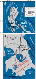
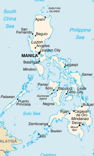
Composed of 13 cities and 4 municipalities, Metro Manila is situated in the Island of Luzon, where many earthquake faults lie in a north-south direction. Among these are: the Marikina Valley Fault, Philippine Fault, Lubang Fault, Manila Trench, and Casuguran Fault.


The residents of Metro Manila are, in fact, living literally on top of the Marikina Fault line, the Manila Trench and Manila Bay. Click picture on the right to increase size and read more data.


With a population of 10 million, Metro Manila is densely populated. Many of its buildings do not comply with construction standards and are prone both to fire and damage by earthquake of any magnitude.


Punongbayan’s "Theory of Probability"


Right after the Mt. Pinatubo eruption in 1991, then Philvocs Director Raymundo Punongbayan warned of a greater probability for a major earthquake in the Marikina Valley Fault, after centuries of major inactivity. The fault is recorded to have only caused two major earthquakes within the last 1,400 years.  The last one was  way back in the 16th century.  . With such span of time in between major activities, it is difficult to establish a pattern of frequency or recurrence for the Fault.


Punongbayan also emphasized then the danger of building structures within five kilometers from the Fault line. His warning caused alarm among the business community, prompting Marikina local officials to request to have the Fault’s name changed to “West Valley Fault” instead, to remove the stigma from being attached to their town’s name.

.

Japan-funded study singles out the Marikina Valley Fault Line


The Metropolitan Manila Earthquake Impact Reduction Study (MMEIRS), which was funded by the Japan International Cooperation Agency (JICA) and supported by the MMDA, DOST, Philvocs and two JICA contractors, begun last August 2002. It identified the Marikina Valley Fault, which lies northwest of Manila, 'as the fault that is expected to cause the largest impact in the metropolis.” It traverses Marikina, Pasig City going all the way to Muntinlupa up to the south.


A Philvocs scientist involved in the Impact Reduction Study estimated the Fault’s return period at 200-400 years, and said it is due for another movement. Since studies have a big margin of error, however, he said that there is no reason for people to panic because there is no timetable, yet. He emphasized the need for people to be prepared because the coming of a real "big earthquake" in Metro Manila  would be inevitable.


The MMEIRS actually aimed to design a master plan to reduce the impact of earthquakes in Metro Manila, by preparing and studying all types of earthquake impact scenarios.


Separate studies are also being conducted in cooperation with China, Japan and the United Nations Development Program (UNDP). Three areas were tested under the MMEIRS study: Mataas na Lupa in Malate, Manila; Ugong, Pasig; and Cupang, Marikina. Studied were Metro Manila’s three fault lines, the Marikina Valley Fault line, the Manila Trench and Manila Bay.


Experts looked into these areas’ earthquake history, length of the fault lines and vulnerability to earthquake. Damage scenarios and estimated costs of destruction were also prepared and studied. (Excalibur News) 

TOP OF PAGE

The Metropolitan Manila Earthquake Impact Reduction Study: 

A Doom's Day Scenario
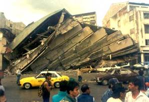
The Metropolitan Manila Earthquake Impact Reduction Study (MMEIRS) cites “many research studies indicating that active phases of the Marikina Valley Faults are approaching and that estimated magnitude will be around 7 or higher. It also raised the possible intensity from 7 to even 9, which could be devastating.”

The study virtually painted  a doom's day scenario of a Marikina Fault earthquake that is sure to happen! It projected a "big" earthquake that is "unlike any tragedy seen or imagined in Metro Manila" claiming that 35,000 Metro Manila residents  would die and up to three million others would have to be evacuated. The study said that some 175,000 buildings would be damaged, and continued to say that the pressure of collapsed buildings and the inability to rescue those who would be trapped inside would cause most of the deaths.

The seismic intensity generated by a Marikina Valley Fault earthquake and the damage that could be felt in an area varies from place to place. The intensity can range from 7 in Quezon City, almost 8 and 9 alongside Marikina River and Manila Bay, and 8 at west of Metropolitan Manila and 7 in other areas. Based on the Philvocs Earthquake Intensity Scale (PEIS), intensity 7 is “destructive,” intensity 8 is “very destructive” and intensity 9 would be “devastating.”

Aside from the estimated death toll, a Marikina Valley Fault earthquake would cause injuries to 118,200 persons, the study continued. The death toll would be higher if the earthquake occurs during office hours where most of employees are working inside buildings, including people who come from the province to transact various matters in the metropolis.

A Manila Trench earthquake, on the other hand, is expected to destroy about 5,000 buildings, and another 16,000 could be destroyed in the Manila Bay fault. The Marikina Valley Fault earthquake will cause the collapse of buildings in northeastern Quezon City, western Marikina, eastern Pasig, Muntinlupa-Laguna Bay and Mandaluyong-Makati. Evacuation would be difficult in the perimeter of the metropolis particularly in the north, Taguig and Las Piñas, the MMEIRS study also found.  

The MMEIRS estimates the number of refugees or evacuees at three million, which will include victims of fires and liquefaction caused by the earthquake. The figure would include 1.3 million persons who would be uprooted from their homes if the aftershock would last about seven days.

Liquefaction could cause a possible regional separation of Metro Manila, with the western part of the metropolis isolated from its other parts. The same thing would happen to the northern and southern parts due to building collapse especially in the area intersecting Makati and Mandaluyong. Meanwhile, all road networks running east-west that are on the fault would be broken, the study concluded.

Other infrastructures such as bridges and power posts will also be destroyed. Collapses would lead to electrical short circuit, petroleum and LPG leakages from storage tanks, among others, would cause fire. The study identified the areas highly vulnerable to fire as Valenzuela, Caloocan, and south of Quezon City west intersection.

The Angat reservoir and water purification plant would likely be damaged, causing a long-term stoppage in water supply. Public transportation facilities such as airport runways would be closed, leaving only helicopters available for operations. Ports in the North and South harbors would be damaged and tilted by liquefaction, making these inaccessible for loading and unloading. Damages would likely be expected on roads and bridges.

Residential buildings around Malacañan Palace in Manila and the House of Representatives in Quezon City would be severely damaged. The danger of spreading fire to the Malacañan presidential office is not ruled out. Liquefaction around the Batasang Pambansa Complex might take place. Even the MMDA building would be severely damaged, the study adds. (Excalibur News) 

TOP OF PAGE

.

The Philippines

in the Pacific

“Ring of Fire”

The Philippines is part of the Pacific “Ring of Fire” and is one of the most seismically active countries in South East Asia. It has 220 volcanoes, 22 of which are potentially active.

Our archipelago is situated in the collision zone of the Philippine Sea Plate sub-conducting in the east and the Eurasian Plate sub-conducting in the west. The oblique convergence of both plates produced the Philippine Fault System that traverses the entire length of the archipelago. It registers an average of 1,700 earthquakes a year, around sixteen of which would be strong enough to be felt. This would mean four to five earthquakes of varying intensities every day.

The Philippine Fault System has produced several of the most destructive earthquakes in history. According to Philvocs, the country experienced 12 destructive earthquakes between 1968 and 2003. Click picture below to increase size and read more data.

tectonic environment In August 2, 1968, an earthquake caused the collapse of the Ruby tower buildings, leaving hundreds trapped underneath the rubble. 

In August 17, 1976, an earthquake caused a tsunami that killed 8,000 people in Mindanao. 

The country experienced its most destructive earthquake last July 16, 1990. With a magnitude of 7.8 in the Richter scale, it left 1,620 dead, 3,500 injured and 148,000 homeless. It affected 23 provinces in six regions of Luzon, and devastated 3 cities – Cabanatuan, Dagupan and Baguio cities. Damages were estimated to have reached P12.2 billion. Unequalled in deaths, property damage and psychological shock, it was ranked among the major earthquakes of the world.

We witnessed the Mt. Pinatubo volcanic eruption in June 1991, which was considered as the worst volcanic eruption of the century. (Excalibur News) 

TOP OF PAGE


Multiple large earthquakes in the past 1,500 years on a fault in metropolitan Manila, The Philippines (A study published in the Bulletin of Seismological Society of America, 2000, vol. 90, p. 73-85)


FRONT PAGE | TOP OF PAGE | NEXT PAGE

 View our 2004 Archives | View our Guest Book | Sign our Guest Book