Concord High School
Return to Schedule Page
Map Concord High School
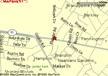
Local Area Map of CONCORD HIGH SCHOOL
Get local info - Click on the map
DIRECTIONS:
Exit the High School on Whitehall Road
Head NorthWest(left) towards Germantown Pike
Turn Right on Germantown Pike, head towards Plymouth Meeting
Take the I-476 SOUTH ramp
Merge onto I-476 S.18.2 miles
Take the I-95 SOUTH exit towards CHESTER.0.6 miles
Merge onto I-95 S.2.8 miles
I-95 S becomes I-95 S/US-322 W.0.7 miles
Stay straight to go onto I-95 S.2.8 miles
Take the I-495 SOUTH exit, exit number 11, towards PORT OF WILMINGTON/BALTIMORE.0.2 miles
Take the SR-92/NAAMANS RD ramp.0.2 miles
Keep RIGHT at the fork in the ramp.0.1 miles
Merge onto NAAMANS RD/SR-92 W.3.7 miles
Turn RIGHT onto EBRIGHT RD.
You're Here!!
Want to get a detailed driving map to refer to:
Driving Directions Norristown to Concord
Return to the Top of The Page
This Page hosted by

Get your own
Free Home Page