Pittston High School


Return to Schedule Page


Pittston Football


Map of Pittston High School

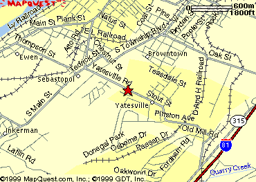
Local Area Map of PITTSTON HIGH SCHOOL


Get local info - Click on the map

Driving DIRECTIONS ( from the High School ):


Exit the High School on Whitehall Road
Head NorthWest(left) towards Germantown Pike
Turn Left on Germantown Pike, head towards Collegeville
Turn Right on 363 Valley Forge Road
Continue on to Sumneytown Pike ( Near North Penn High School)
Turn Left
Proceed to the Pa Turnpike On ramp at Lansdale #31
Merge onto 476 north
Take the PA-315 exit, exit number 37, towards PITTSTON(I-81)/SCRANTON
Merge onto PA-315 N
Turn LEFT onto PA-2035
Turn SLIGHT LEFT to take the US-11 SOUTH ramp
Merge onto US-11 S
Turn LEFT onto PA-2004
There are 0.48 miles (0.77 km) between the end of the directions and 5 Stout St
You're Here!!


From Music on the Mountain or somewhere else up north
If you stay the night in the Area with us
Take 81 south to Pittson Exit(48)
Go left on route 315 go to the second light
After the second light turn right
you will go over a set RR trax then you'll come too a stop sign
Turn left the school is on the left
Return To The Local Area Map


Want to get a detailed driving map to refer to:

Click here: Driving Directions to Pittston Football


For More Info Pittston Area High School
5 Stout Street
Yatesville Pa. 18640
717-654-3541

Visit their school Site
The Pittston Area High School

Visit the Band Home Page
The Pittston Area Marching Patriots

Or the Drumline Home Page
Pittston Area Percussion


Return to the Top of The Page


This Page hosted by
GeoCities

Get your own
Free Home Page