Upper Darby High School
Return to Schedule Page

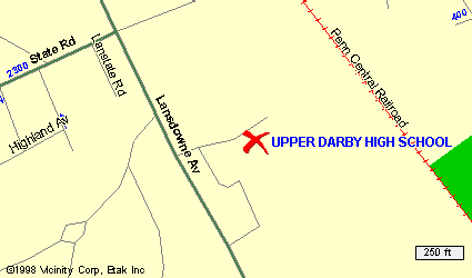
Destination Map
Click here for additional Details and info of the Area
Get local info - Click on the map
DIRECTIONS:
Several Ways to get there, Depends on how familiar you are to the area. First choice would be Expressway, City Line Ave.?Or ride with a friend, or on the Bus
First Way:
East on Germantown Pick up the Blue Route
Blue Route To the Expressway
Expressway to City Line Ave. ( Route #1 )
City line past route #3 to Lansdowne Ave. Turn Left
To State Road. Turn Left. Past Bank. Past Middle School. Field is Behind Middle School.
People will direct you where to park
You're here
Second Way:
East on Germantown Pick up the Blue Route
Blue Route To Route #3 Exit
Route #3 to Lansdowne Ave. Turn Right( Before Route #1 )
Lansdowne Ave To State Road. Turn Left. Past Bank. Past Middle School. Field is Behind Middle School.
People will direct you where to park
You're here
Local Area Map
Local Area Map of Upper Darby
Want to get a detailed driving map to refer to:
Click here for Driving Directions - overall map
Top of Page
This Page hosted by

Get your own
Free Home Page

