Dominated by the massive rocks of Negoiu, this area includes: Puha mountain to the west (2177 m) with its long ridge towards the Fagaras depression, Puha Saddle, Mizgavu mountain's crests (2277 m), Serbotei summit (2331 m), Custura Saratii with its 2364 m peak to the south; the stone world of the giants begins towards south-east: the Negoiu Mic (2485 m), the Negoi Peak (2535 m) with the Lespezile and the Caltun peak (over 2500 m) behind; eastward, leaning against the body of the Negoiu, the high and massive Muchea Tunsu, covered with Alpine grass and juniper trees docks the view to the other valleys and ridges aligned towards Balea.
All these peaks and crests surround three sides of two huge hollows: the large one of Serbota and that of the Saratii, separated by the Serbota ridge descending abruptly from 2331 m, changing its crenelled shape towards north in a gradual ridge covered with old spruce fir forests.
From the high peaks, the hollows gather up clear and cold springs giving birth to the Saratii and Serbotei brooks, which merge downstream in one valley, where Porumbacu river forms uproaring waterfalls carrying towards the plains 'news' and 'rumors' from the heights.
On the northern foot of the Serbotei ridge, at the limit between the forest and the mountain area, the greatest touristic base in the Fagaras mountains is located.

THE NEGOI CHALET

  • altitude 1546 m
  • accomodation 170 beds
  • dining room 110 seats
  • hot meal, refreshment room
  • electric lighting
  • wood heating
  • skiing slopes
  • Prices between 5-11 euros/person in lei; rooms from 2 to 10 beds.
    Approaches:
  • mountain line- from Suru, Barcaciu, Balea Lac, Podragu chalets
  • from the main road
  • Porumbacu de Jos train station

    Information about the chalet tel: 0744573875 and 0269210607
  • Call for cars for the transport of the tourists from the train station to the forest road head (22km) tel: mr. Aurel 0723751823, mr. Nicodim 0745588180 and 0269522336, mr. Lazar 0721467699, mr. Cristea 0744548315 and 0269522770
    Starting points, approaches, routes  
    Route no. 1
    Porumbacu de jos commune- Porumbacu de sus village (6km country road);
    Porumbacu de sus- forest road head in upstream (16 km);
    Forest road head- the Negoi chalet (1,5 - 2 hours) foot road

    From the center of the Porumbacu de Jos commune, placed on National Road 1- km 281 we follow the communal road until the Porumbacu de Sus village. From here we head the forest road that is marked with a blue triangle which keeps the right of the Porumbacu river. On route one sees pillars with arrows placed at the forest crossroads. After one enters the wood area, the road winds on the river bank and one has first, the inhabited forest cabin 'La casa alba' and secondly, further up the marble quarry as directing points. One keeps the road in upstream till the junction of two streams (Serbota brook on the right and Saratii brook on the left). The transit warehouse of the Negoi chalet (beam building with tiled roof) is placed at 250m. From here one follows the road and then the winding path ascending Serbota foot, that is accessible to all categories of tourists.


    Route no. 2
    Avrig Commune- Poiana Neamtului chalet (14 km)
    Poiana Neamtului chalet- Barcaciu chalet (2,5 - 3 hours) path
    Barcaciu chalet- Negoi chalet (2,5- 3 hours) foot road

    We recommend this route both for visiting two of the chalets near the Negoiu and for the road nearing the massif that is shorter by car.
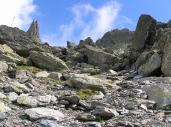
    The route, quite easy, offers the possibility of seeing a pre-alpine mountain zone and we recommend it as a training for those who intend to cross the Fagaras ridge for the first time.
    From the center of the Avrig commune, we cross the place following the red cross sign parallel to the Avrig river. At about 9 km we encounter the forest cabin from Podul Jibrii and the crossroad with another forest road leading on the right to 'Izvorul Florii'. We leave behind the cabin and the crossroad and follow our track to 
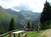
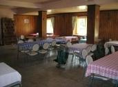
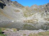
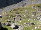
the left for another 5 km towards the Poiana Neamtului chalet, a beautiful settlement located in a large clearing that is moistened by the Avrig brook. One can put up for the night here if arriving too late to go on, or one can park the car and continue
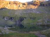
 the trip to the Bărcaciu chalet following the path marked with relatively gentle serpentine windings. Here we make a halt for a light meal, a hot tea, 
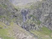
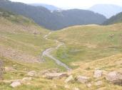
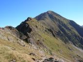
some information from the chalet worker and we continue the track on one of the most beautiful mountain paths to the Negoi chalet, following the mark for about 2 hours and a half. Time passes unnoticed because of the ravishing mountain landscapes, of the mountain covered with fields of bilberries.
    Route no. 3
    Negoi chalet- Saratii valley
    Saratii valley- Saua Cleopatrei (Cleopatra's saddle)
    Saua Cleopatrei- Negoiu Mic- the Negoi Peak- Strunga Dracului (Devil's horn, the entrance in the horn)
    Strunga Dracului (entrance)- we move on to Strunga Doamnei (Lady's horn)- Caldarea Laita (Laita hollow)
    Caldarea Laita- Strunga Ciobanului (Shepard's horn)- Caldarea Saratii
    Caldarea Saratii- the Negoi chalet (7-8 hours, including a one-hour halt by choice)

    We recommend that the beginners, well equipped and informed about the track by the man at the chalet, travel in this direction on short distances, as a testing exercise, for example to the Negoi peak only, and then back to the chalet on the same track. Or, crossing Strunga Ciobanului, admiring the massive giants from across this gate of the Negoi for about half an hour, then return to the chalet on the same way.
    Route no. 4
    Negoi chalet- Caldarea mare a Serbotei (the great hollow of Serbota)- Saua Puha (Puha saddle)
    Saua Puha- Mizgavu mountain- the Serbota peak
    the Serbota peak- the Negoi chalet (7 hours, including a half-an-hour rest)

    From the Negoi chalet we take the marked path which leads us to the valley of Serbota where, after crossing the beam foot bridge over the brook, we start climbing towards the Serbota hollow, leaving on our right the mark to the Bărcaciu chalet. We go on our marked track through the forest. The route ascends first gently, then the slopes get steeper over the edges of the hollow, simultaneously with the opening of the surrounding sights. In about two hours we reach saua Puha, where we see the ridge mark which we follow (to the left, that is, eastwards). The path becomes more abrupt, we cross the peaks of Mizgavu and with a little more effort we reach Serbota peak from where we have a magnificent sight of the great heights and where we can hear THE SILENCE.
    We make a second halt and start descending the ridge of Serbota following the mark which takes us to the Negoiu chalet.

    Cabana Negoiu@yahoo.com


    Maps

    The map of the Făgăras mountains: Negoiu, Bâlea and Podragu area

    Fagaras 2.6M
    Fagaras 4.5M
    Fagaras 740K
    Fagaras 950K
    Fagaras 11M

    Fagaras 1,2M Fagaras 1,3M Fagaras 1,2M Fagaras 1,2M
    Fagaras 900K Fagaras 900K Fagaras 900K Fagaras 900K

    Fagaras seen from the north 11.1M
    Fagaras seen from the south 12.7 M
    Fagaras seen from the west 9.8M
    Negoiu 145K
    Urlea 120K
    Transfagarasean 612K
    Balea 550K
    Ruda 190K
    Fereastra Zmeilor 204K