The Storm that Never Came
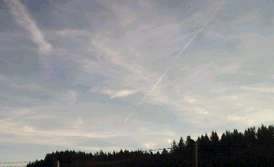
Here in Powell River B.C. we have had a lot of storms coming in. The last storm half blew over a tree near the house. The skies turned clear and sunny again, but the jets were starting to spray very heavy. They were coming in from all sides in pairs. Side by side they sprayed till the sky was filled with white overcast.
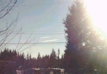
I wanted to get the tree cut down because there was another big storm front moving in and was expected to arrive that Saturday. During all this time the jets were flying non-stop, and at different times were only ten minutes apart. Two jets would fly from my left as another pair would face them from the right.
So guess what happened? The storm never came Saturday. In fact we now have a high pressure ridge holding the storm off the coast. Click Here to see the satellite image. It is Monday the 24th of December today and no sign of a storm.
So what does this mean? It means that there will now be less water to fill up the damns in the eastern provinces of Canada. Last year saw one of the biggest droughts in the prairies in a very long time. As I speak watershed levels are dropping.
What appears to take place is that the white mist seems to absorb all moisture and then move out before the cumulous clouds move in. This means that they will have no moisture to collect and dry out. What happens is that they should build and build with moisture. Like a snowball rolling down a hill, they should take in more and more moisture as they dump it out as they move across the prairies. Note to that the prairies are Canada's wheat fields to the world. I suspect HARRP may have created the high pressure over British Columbia.
http://www.oocities.org/canadianchemtrails