


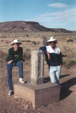
Corner of Colorado-New Mexico-Oklahoma
 Fall 1993
The view in this photo is to the west. I am standing in the
northeast corner of New Mexico. That's my dad standing in Colorado.
You may be able to just make out the fenceline behind his hat -
that's running along the Colorado-New Mexico line. The northwest
corner of Oklahoma's panhandle is just to the left (south) of the
camera - and directly in front of me. You may be able to read the
state names inscribed on the marker.
According to the Congressional definition of the boundary of
Colorado, this point is theoretically where the 37th parallel north
latitude intersects 103 degrees west longitude. The first three
attempts to locate this intersection (1857, 1859, and 1881) were
later found to be in error. The fourth (and finally accepted)
location was set in 1900 by Levi Preston. However, due to the
technological limitations of his day, it's not exactly right either
(but it's remarkably close - and at any rate, his survey does define
the official boundary, regardless of its accuracy). This was
originally a sandstone monument, but during his 1908 resurvey Arthur
Kidder replaced it with the current granite marker shown above.
NOTE: The book "Colorado Mapology" (Erl H. Ellis, 1983,
Jende-Hagan Book Corporation) is an excellent resource, from which I
obtained much of the information presented on these pages.
Page created in 1998; last updated 28 February
2003.
|