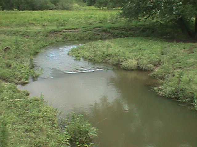
Seeley Creek #1
| Dissolved Oxygen | 9 mg/L |
| Nitrate | 2.2 mg/L |
| pH | 8.0 |
| Turbidity | 7 NTU |
| Velocity | .416 m/sec |
| Temperature | 21 C |
| Description | Creek surrounded by cow grazing areas; near farm. A dam is upstream. | |
| Width | 4.3 meters | |
| Water Appearance | Clear | |
| Odor | None | |
| Attachment Sites | 14/20 | Riffle is as wide as stream but length is less than 2 times width; cobble less abundant; boulders and gravel common. |
| Embeddedness | 4/20 | Fine sediment surrounds and fills in more than 75% of the living spaces around and in between the gravel, cobble, and boulders. |
| Shelter For Fish | 10/20 | Snags, submerged logs, undercut banks, cobble and large rocks, or other stable habitat are found in over 30% of the site. |
| Channel Alteration | 10/20 | Artificial embankments present to some extent on both banks; and 40 to 80% of stream site straightened, dredged, or otherwise altered. |
| Sediment Deposition | 12/20 | Some new increase in bar formation, mostly from coarse gravel; 5-30% of the bottom affected; slight deposition in pools. |
| Channel Flow Status | 16/20 | Water reaches base of both lower banks and minimal amount of channel substrate is exposed. |
| Bank Vegetative Protection | LEFT:4/10; RIGHT:4/10 | 50-70% of the streambank surfaces covered by vegetation; patches of bare soil or closely cropped vegetation common; less than one-half of the potential plant stubble height remaining. |
| Condition of Banks | LEFT:6/10; RIGHT:7/10 | Moderately stable; infrequent, small areas of erosion mostly healed over. |
| Riparian Vegetative Zone Width | LEFT:0/10; RIGHT:0/10 | Width of Riparian Zone is less than 20 feet. |
orderSample OneSample TwoSample ThreeTrichoptera | 36 | 18 | 2 | 56
| Odonta | 2 | 0 | 0 | 2
| Decapoda | 1 | 0 | 0 | 1
| Gastropoda | 1 | 3 | 0 | 4
| Pelecypoda | 3 | 13 | 0 | 16
| Amphipoda | 2 | 6 | 24 | 32
| Ephemeroptera | 3 | 0 | 8 | 11
| Diptera | 1 | 11 | 12 | 24
| Coleoptera | 1 | 0 | 35 | 36
| Hirurdinearae | 0 | 3 | 1 | 4
| Plecoptera | 0 | 0 | 1 | 1
| TOTAL |