COLREG
The Rules of the Road (COLREG) are an international convention to avoid collisions at sea. They consist of 38 rules grouped into 5 parts. Part B is about the steering and sailing rules and there you find the rules about the lookout, safe speed, how to detect a risk of collision and how to react if such a risk exists. It also includes rules about the conduct of vessels in bad visibility and the responsibilities between different kinds of vessels. It tells you how to behave in head on situations, crossing situations, when overtaking another vessel or if being overtaken.
RADAR
Radar is very important on the bridge. In bad visibility it is the only means to detect another vessel or other target in time for efficient collision avoidance. It can also be used for navigation purposes and to receive weather information by seeing wave or rain echoes.
The radar antenna is placed in the rigging of MIR and sends electromagnetic waves to the front, back and the sides of the ship. If these waves meet metal they get reflected and return to MIR where the radar antenna collects them again. In accordance to the time and intensity of the refection the computer calculates the size and distance of the object. In case of no other ship inside the chosen radius the radar switches on standby modus, but returns automatically if any reflection appears. In the case of a possible collision an acoustical alarm is given. Unfortunately there is one problem with this useful instrument if it is used on square-rigged ships. Their own sails produce blind patches in accordance to the position of sails. This is a reason why very often no sails are set in misty weather.
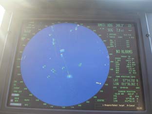
ARPA - Automatic Radar Plotting Aid
Having worked a lot with ARPA during my last voyage I want to give those who are no professional navigators a short inside into this technique.
ARPA stands for Automatic Radar Plotting Aid. It is a radar system of the high end of technology.
On MIR we have an ARPA which allows us to change between different projections so that every watch officer can choose the one he likes best. If working with ARPA in connection with ECDIS (Electronic chart display and information system) the "Relative Motion / North Up / off-centre / true vectors" projection has proved to be most handy and so this was the projection which was normally installed when we were on the watch.
The system we use on MIR also allows us to choose between different ranges. This starts from 0,5 miles and goes as far as 96 miles. However, in the waters where we were sailing 96 miles is absolutely useless as radar cannot "look around corners". I really doubt that it is of any use anywhere because anything 96 miles away is not really relevant for navigation except for a landfall towards a very distinctive coastline after crossing an ocean. I have no experience on it being used in connection with weather forecasts, but maybe it is possible to receive some information about bad weather ahead from the 96 miles picture.
For our voyage we normally used a range of 12 miles. However, when in narrow waters often 6 Miles or for an approach even 3 miles seemed to be more handy. In the open sea speeding with 15+ Kt. we sometimes use the 24 miles screen. On a radar screen the own ship normally appears in the centre. However with modern tools this is not the rule any more. We used our radar screen decentralised to give us more information of what is going on ahead.
The ARPA now projects us the targets not only like a green spot or azimuth as traditional radars do. It already shows the vector of motion so that we can decide whether a target is of interest for us or not. Those which might come near to us or might cross our track can acquired with a track ball and we can receive further information about them: speed, course, how close they will come, when this will be. Additionally every target we acquire will appear on the ECDIS so that we can watch it's moving not only while standing directly in front of the radar screen but also from the chart desk. Having an ECDIS-display in his cabin the master can watch it while he is working on his desk. Another display is standing on the training bridge so that everybody on board can at any time see where we are and what is going on in our surrounding.
However, if you are not near the display and not near the radar screen the ARPA also gives acoustic warnings for each vessels that comes into the chosen closest passing distance. While in relative motion projections any standing bearings can easily be seen in true motion you need to take bearings to find out if there is a risk of collision. You can do this directly on the ARPA screen and it is actually not much different from taking bearings to vessels in sight. However, being a school ship MIR also has a traditional radar set on the bridge to give the students the possibility to train working with simpler technology. This is a north up projection which is only connected with the gyro compass and works just in the same way as the radar on any yacht. It is also used as backup in case the ARPA does not work or if people are working aloft on the fore mast near the antenna of the ARPA radar and it therefore has to be switched off. The antenna of the traditional radar set is situated on the mizzen mast.
After 2 weeks in good weather with good visibility one morning we were anchoring in deep mist. We could not see the main mast from the bridge. As I knew from previous radio contact the KRUZENSHTERN was anchoring just 3 cables from us. However, on the radar she looked not different than a buoy and if I had not known she was there I would have never thought it from what information the ARPA gave me. It takes a lot of experience to interpret a radar picture correctly and it is the same with ARPA. Only if you permanently practice this during times with good visibility you will be able to see something on the screen in bad weather. Professional navigators are only allowed to navigate with ARPA in bad visibility if they have had some special ARPA training and prove to have a certain amount of practical hours of work with ARPA every year.