
Aerial Photos of the Sahyadris
This is a collection of aerial photos of the Sahyadris. Feel free to download these photos to your computer and distribute them to your friends. More photos are being added here constantly, so keep checking.
All these photos are in PDF format. If you are unable to view these photos, you can download the PDF viewing software for free from the Adobe website at www.adobe.com.
To view any photo, simply click on the preview image or the title. If you have a PDF viewer on your computer, the photo will show up. It may take some time for the photos to appear, depending on the speed of your internet connection. Click on the 'save' icon in your PDF viewer to save the photo on your own computer.
|

|
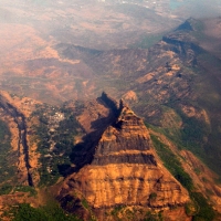
The rock face of Chanderi is a very familiar image not just to hikers but to any traveller in the Mumbai-Pune area. Check out how it looks from the air! (Image size: 117 KB)
|

|
These two adjacent peaks located about 10 km to the east of Khandala present an interesting aerial sight. (Image size: 238 KB) |
|
A great view of Haji Malang with Tavli in the background. Note the large settlements on the plateau below the rock face. (Image size: 626 KB)
|

|
Another view of Haji Malang; no wonder they say it is so dangerous to climb to the summit of this peak. (Image size: 1059 KB)
|

|
The Tavli pinnacles are clearly visible in the background while the expanse of Badlapur Hill is seen in the center. (Image size: 641 KB)
|

|
A detailed image of the southern edge of Matheran, with Chauk and One-Tree-Hill points clearly visible. (Image size: 827 KB)
|

|
Note the steepness of the south-western edge of the Matheran plateau. In some places, it has a gradient higher than 90 degrees! (Image size: 754 KB)
|

|
There is so much detail visible in this photo that you can even see the Lion's Head at Louisa Point! (Image size: 690 KB)
|

|
You may have hiked Matheran extensively, but would have not seen this unique perspective. (Image size: 197 KB)
|

|
This view of the northern part of Matheran even has the Neral Matheran road visible, if you look carefully! (Image size: 448 K)
|

|
These series of digital photos extracted from a video cover the entire South-West region of Matheran.
|