 History
Middlebrook Encampment
History
Middlebrook Encampment
The area north of Bound Brook was the scene of two encampments of major portions of Washington's Continental Army during the early summer of 1777, and during the winter of 1778-1779. The first encampment was of strategic importance since it compelled British General Howe to alter his campaign for the summer of 1777.
When the 13-star flag was officially adopted by Congress in 1777, the first place it was flown over continental troops was at Middlebrook.
The "Battle of Bound Brook" was fought on April 13, 1777, when Lieutenant General Lord Charles Cornwallis launched a four-ronged attack on the village of Bound Brook. One account says it was an attempt to capture Major General Benjamin Lincoln and Brigadier General Anthony Wayne, who made their headquarters in the Philip Van Horne House another says it was a foraging run to get food supplies at Bound Brook needed by the starving British. (The Van Hornes, who had loyalist leanings, were enjoying the protection of the British in New Brunswick. American soldiers defeated the British under who fled back to New Brunswick.
See: The Battle of Bound Brook and LincolnBittner.com
In May of 1777, Washington moved his small army of about 6-8,000 men from his winter encampment at Morristown to the Middlebrook Heights, to observe the British troups at New Brunswick and Perth Amboy. Wayne's Brigade, commanded by General Anthony Wayne, from Pennsylvania was camped at the top of the first range of the watchung mountains in an area extending west from the intersection of Vosseller Ave. and Hillcrest towards Chimney Rock. The converted the area into a natural fortress. From this mountain, Washington kept an eye on the British in New York and New Brunswick. More importantly , he was in a position to flank the British if they attempted to cross New Jersey to Philadelphia.
At this time General Howe had 16-18,000 troups in New Brunswick.
This caused Howe to have to move his army by sea, causing a delay which prevented Howe from joining Burgoyne, which led to the defeat of Burgoyne's British army at Saratoga in October, the turning point of the of the Revolutionary War. Hence Middlebrook Heights has been called, "The Beginning of the Winning of the War."
In July and Aug. Washington's army move toward Philadelphia where they eventually lost the battle of Brandwine on Sept 11 and the Battle of Germantown on Oct. 4. They clashed again in the Battle of Red Bank in Nov. and eventually retreated to Valley Forge in December. At that time nearly 3000 men of this force were sick or too nearly naked to do duty.
In Nov. 1778 Washington started moving the army back to the Middlebrook area. The Main army, consisting of the Virginia, Maryland, and Pennsylvania Brigades, with the Delaware regiment, the artillery Corps, and the artisans and attached support units, were along the base of the Watchung Mountains. Here they were protected from some of the weather, had a good supply of trees for construction and firewood, and were supported by a generally patriotic population, with an active militia.
Washington set up his headquarters at the Wallace House in what is now Somerville.
The Virginia troops were posted just west of the gap where Middlebrook creek flows out of the mountains, at Chimney Rock. The Virginia position extended along today's Foothill Road. The Maryland Brigade was posted east of the gap, past Vossler Avenue along what is now Middlebrook Rd. almost to Mountain Avenue. The Pennsylvania Brigade were posted south, at Weston, in today's Manville. Several miles north west along the ridge, at Pluckemin, the Artillery Corps was stationed, with an extensive academy/barracks construction
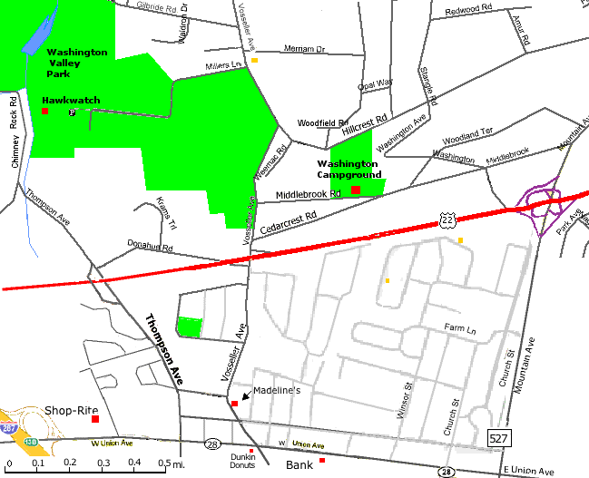
The 20 acre park at 1761 Middlebrook Rd., east of Vosseller Ave.
is operated by the Washington Campground Association.
Legend has it that the land was donated to the Washington Camp Ground Assn.
on the condition that the Declaration of Independence be read every 4th of July,
or the land would revert to the heirs of the LaMonte family who donated it.
This has occurred fo 112 consecutive years.
They also have an annual meeting on Washington's Birthday, February 22
Annual Meeting - Feb. 22 Open to the public
Location: Madeline's - 518 Vosseller Ave., Bound Brook (See map below)
7:00 PM - Welcome, Business Meeting (election of officers, ...)
8:00 PM - Historical Talk
8:30 PM - Desert (Cherry pie and cobbler)
Fourth of July Patriotic Exercises
Location: 1761 Middlebrook Rd., Boundbrook (See map below)
The annual ceremony includes (times are approximate):
10 AM Music
10:30 Welcome & changing of the flag
10:40 March to East Grove stage
10:45 Introduction of dignitaries
10:55 Reading of the Declaration of Independence
11:05 Keynote Speaker
11:15 An historical address
11:30 Benediction
Contacts: Robert Fazen - Pres. robert@fazen.org, John Haelig, Jr. - VP, Herbert Patullo - VP 732 469-4177,
Dick Shive - VP 732 469-2682, Phil Schuyler - Treas 732 469-6453
A shuttle bus will run from the Somerset Savings Bank (220 W Union Ave. - Rt 28) in Bound Brook starting at 9:30.
Campground Assn Membership $10
To: Mike Schuyler
913 W. Meadow Dr.
Bound Brook, NJ 08805
The army actually covered a large area in the first and second range of the Watchung Mountains from Chimney Rock Rd. to King George Rd. (which continued all the way down the mountain then) and up to Dock Watch Hollow Rd. The park on Middlebrook Rd. has a small monument, flag and seating for the July 4th ceremony.
The Somerset County Cultural and Heritage Commission is considering establishing some historical landmarks in the area south of Miller lane. They have hired Hunter Research, an archaeological research firm in Trenton, to research the area near Vosseller Ave. and Miller Ln. to determine what of interest remains from the Revolutionary encampments.
Somerset County added this property (gift from Herbert Patullo and purchases) between Vosseller Ave. and Chimney Rock Rd. to Washington Valley Park .
In 1973-74, A. A. Boom, a local historian who conducted tours of the area around Miller Lane, did an extensive investigation of the rock walls in the area, which is documented along with a history of Washington's army encampments in Chapter 11 of "North of the Rariton Lotts: A history of Martinsville, NJ area".
In 1974, William Liesenbein, performed a archaeological investigation of the same area. He refutes some of Boom's claims that most of the walls were set up for fortifications, but did admit that some may have been. He also found features which he speculates could have been huts and kitchens in 1777.
Click on map for interactaive version.
1777 Scull Map,
1778/9 Angelakos Map,
Boom Map showing stone walls, Liesenbein Map showing stone walls
Ref: Somerset Co. Historic Sites
A. A. Boom (deceased) manuscript and Chapter 11 in "North of the Rariton Lotts: A history of Martinsville, NJ area describing rock walls between Vosseller and Chimney Rock.
Local Historians:
Ernest Richard Bower - Describes some of his finds in the area described above in Revolutionary War "At the Crossroads"
Kels Swan - Former Historian at Washington Crossing State Park has a wealth of knowledge on local history.
Rutgers Cartography Historical Maps
Images of early maps on the web
George Washington's Map Maker (New Brunswick, N. J.: Rutgers University Press, 1966).
A detailed account of the maps William Scull produced while he was working under Erskine and his successor, Simeon De Witt, that are now in the collections of the New-York Historical Society
Original maps in the Erskine-DeWitt Series (Guthorn 1966: 18, 19, 32)
at the New York Historical Society collections.
(Index Entry at: Bobcat.NYU.edu)
"Report on a Preliminary Archaeological Investigation of the Alleged Site of the 1777 Summer Encampment
of Wayne's Brigade at Middlebrook, NJ",
Wm. Liesenbein, Tucson AZ, 1974
Liesenbein Map showing stone walls
1777 Scull Map, 1778/9 Angelakos Map,
"Middlebrook, The American's Eagle's Nest" by Carl Prince, an 88 page booklet available from the Somerset County Historical Society
"Images of America, Somerset County, Crossroads of the American Revolution", William A. Schleicher and Susan J. WInter.
"The Mapping of New Jersey, The men and the art.", J. Snyder, Rutgers University Press, 1973
See Also:
Middlebrook Encampment at lincolnbittner.com
Revolutionary War
New Jersey During the Revolution
Revolutionary War "At the Crossroads"
By Ernest Richard Bower
The Middlebrook Winter Encampment of Washington's Army December, 1778 to June 1779 by Glenn Valis.
American Forts
Martinsville History
Somerset Co. History and Historical Associations
An article from the Courier News.
Return to: Martinsville Information