| Tahoe Weather | |
|---|---|
| Tahoe
> Weather
|
|
Contents: Current Conditions | Sample Averages | Cooperative Observer Network (COOP) Stations | Snowfall
Current Conditions:
Weather Chnl: Lake Tahoe, Tahoe City Fire Restrictions (Tahoe NF, Tahoe Basin | |||||||||||||||||||||||||||||||||||||||||||||||||||||||||||||||||||||||||||||||||||||||||||||||||||||||||||||||||||||||||||||||||||||||||||||||||||||||||||||||||||||||||||||||||||||||||||||||||||||||||||||||||||||||||||||||||||||||||||||||||||||||||||||||||||||||||||||||||||||||||||||||||||||||||||||||||||||||||||||||||||||||||||||||||||||||||||||||||||||||||||||||||||||||||||||||||||||||||||||||||||||||||||||||||||||||||||||||||||||||||||||||||||||||||||||||||||||||||||||||||||||||||||||||||||||||||||||||||||||||||||||||||||||||||||||||||||||||||||||
Lake Tahoe
Source: Temp. -Weather Channel (Tahoe City) ; Snow Depth - S Tahoe at USA Today; Snow - Squaw Valley Lodge at the Western Regional Climate Center
Air Temperature:
Tahoe basin Precipitation: | |||||||||||||||||||||||||||||||||||||||||||||||||||||||||||||||||||||||||||||||||||||||||||||||||||||||||||||||||||||||||||||||||||||||||||||||||||||||||||||||||||||||||||||||||||||||||||||||||||||||||||||||||||||||||||||||||||||||||||||||||||||||||||||||||||||||||||||||||||||||||||||||||||||||||||||||||||||||||||||||||||||||||||||||||||||||||||||||||||||||||||||||||||||||||||||||||||||||||||||||||||||||||||||||||||||||||||||||||||||||||||||||||||||||||||||||||||||||||||||||||||||||||||||||||||||||||||||||||||||||||||||||||||||||||||||||||||||||||||||
Recent Years: 1910-2008 av. 32 in 1995-1999 av. 50 in 2000-2004 av. 26 in 2005 38 in 2006 48 in 2007 20 2008 19 |

| ||||||||||||||||||||||||||||||||||||||||||||||||||||||||||||||||||||||||||||||||||||||||||||||||||||||||||||||||||||||||||||||||||||||||||||||||||||||||||||||||||||||||||||||||||||||||||||||||||||||||||||||||||||||||||||||||||||||||||||||||||||||||||||||||||||||||||||||||||||||||||||||||||||||||||||||||||||||||||||||||||||||||||||||||||||||||||||||||||||||||||||||||||||||||||||||||||||||||||||||||||||||||||||||||||||||||||||||||||||||||||||||||||||||||||||||||||||||||||||||||||||||||||||||||||||||||||||||||||||||||||||||||||||||||||||||||||||||||||||
|
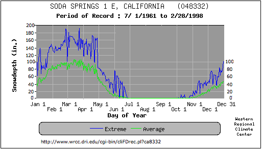
See: 1999 USGS Fact Sheet 035-02 TERC State of the Lake Soda Springs
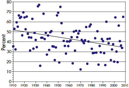
SnowfallSnow Report Links on the Ski PageJanuary, February, March and the beginning of April are the best ski months. 1 year in 10 will have snow at Thanksgiving. The end of December and end of April will have decent skiing 60% of the time. Smaller areas close at the beginnig of April, larger areas stay open till May. See ski page. 1 year in 10 will have decent snow in May.
Snow has declined as a fraction of total
precipitation, from an average of 52
percent in 1910 to 34 percent in present
times.
Historical data from Informative Ski Reports and Other Ski Links by Tony Crocker
California Snowpack Conditions (History of Snow Surveying) at the Dept. of Water Resources (cdec.water.ca.gov)
Donner Summit:
NOAA/NWS Cooperative Observer Network Stations
OtherPrecipitation:
Truckee River flow: Snowfall Tracking StationsStations with Snow Depth or Snowfall information
Ski areas report average snowfall of 34-38 feet. The 2004-2005 season had more than double the average snowfall. Kirkwood reported a total of 66 feet. Greatest Sierra snowstorms (1949-50 through 2004-2005) with storm total snowfall amounts (in.) At various locations Can - canyon dam (plumas county) boc - Boca (nevada county) css - central Sierra snow lab (nevada-Placer county) tah - Tahoe City (placer county) grg - Grant Grove (tulare county) can boc css tah grg 1. Jan. 10-17, 1952 108.0 68.0 141.0 149.0 68.0 2. Mar. 28-Apr. 1, 1982 26.0 47.0 125.5 59.0 63.0 3. Mar. 29-Apr. 4, 1958 46.5 48.0 mm 98.5 69.0 4. Dec. 28, 1992-Jan. 2, 1993 74.0 47.0 76.6 57.5 mm 5. Mar. 21-24, 1995 32.0 26.0 100.6 74.0 59.0 6. Mar. 10-14, 1967 60.0 59.0 74.8 92.0 38.5 7. Jan. 31-Feb. 4, 1975 62.0 38.0 65.0 42.0 25.0 8. Dec. 27-31, 1964 46.0 42.0 87.2 77.0 26.0 9. Feb. 23-26, 1969 35.0 28.0 74.0 37.0 63.0 10. Jan. 27-30, 1981 24.0 24.0 72.0 40.0 48.0 11. Dec. 21-23, 1996 23.0 65.0 53.6 73.0 25.0 12. Dec. 29, 2004-Jan. 2, 2005 48.0 49.5 89.7 64.0 mm 13. Feb. 9-12, 1959 43.0 31.0 mm 43.0 64.0 14. Feb. 16-18, 1990 30.0 49.0 73.0 46.0 24.0 15. Jan. 20-23, 1997 34.0 18.0 73.4 44.0 35.0 Mm - missing data Range at CSS 4'-6" (54") to 11'-9" (141") -- Source: Public Information Statement, TUE JAN 01 2008, from the National Weather Service Reno Weather Forecast Office. Links: Warings and Alerts at the Emergency Info. page Historical data from Informative Ski Reports and Other Ski Links by Tony Crocker
LINKS: | |||||||||||||||||||||||||||||||||||||||||||||||||||||||||||||||||||||||||||||||||||||||||||||||||||||||||||||||||||||||||||||||||||||||||||||||||||||||||||||||||||||||||||||||||||||||||||||||||||||||||||||||||||||||||||||||||||||||||||||||||||||||||||||||||||||||||||||||||||||||||||||||||||||||||||||||||||||||||||||||||||||||||||||||||||||||||||||||||||||||||||||||||||||||||||||||||||||||||||||||||||||||||||||||||||||||||||||||||||||||||||||||||||||||||||||||||||||||||||||||||||||||||||||||||||||||||||||||||||||||||||||||||||||||||||||||||||||||||||||
|
Weather Chnl: Lake Tahoe, Tahoe City weather central. Current Conditions from the Forest Service USA Today: Tahoma Pacific Coast Satellite Yahoo Natl Weather Svc Storm Warnings Weather Page at Ski Homewood NWS Weather Reports weather.noaa.gov: Emigrant Gap, Blue Canyon I-80 and Truckee South Lake Tahoe El Nino theme page |
Snow Report Links and Ski Area Closing dates on the Ski Page At USA Today Snow Reports at SkiLakeTahoe.com/ At SkiCentral Snow accumulation at: Weather Underground, National Weather Service 5/15/2006 National Operational Hydrologic Remote Sensing Center (NOHRSC) Weather CAMs: At USA Today, North Shore near Kings Beach.
| ||||||||||||||||||||||||||||||||||||||||||||||||||||||||||||||||||||||||||||||||||||||||||||||||||||||||||||||||||||||||||||||||||||||||||||||||||||||||||||||||||||||||||||||||||||||||||||||||||||||||||||||||||||||||||||||||||||||||||||||||||||||||||||||||||||||||||||||||||||||||||||||||||||||||||||||||||||||||||||||||||||||||||||||||||||||||||||||||||||||||||||||||||||||||||||||||||||||||||||||||||||||||||||||||||||||||||||||||||||||||||||||||||||||||||||||||||||||||||||||||||||||||||||||||||||||||||||||||||||||||||||||||||||||||||||||||||||||||||||
|
| |||||||||||||||||||||||||||||||||||||||||||||||||||||||||||||||||||||||||||||||||||||||||||||||||||||||||||||||||||||||||||||||||||||||||||||||||||||||||||||||||||||||||||||||||||||||||||||||||||||||||||||||||||||||||||||||||||||||||||||||||||||||||||||||||||||||||||||||||||||||||||||||||||||||||||||||||||||||||||||||||||||||||||||||||||||||||||||||||||||||||||||||||||||||||||||||||||||||||||||||||||||||||||||||||||||||||||||||||||||||||||||||||||||||||||||||||||||||||||||||||||||||||||||||||||||||||||||||||||||||||||||||||||||||||||||||||||||||||||||