Costa
 Located west of the great Andean range, is an area traversed by a coastal cordillera, and a relatively flat plain with extensive alluvial stretches. The coast supports three main tupes of ecosystems: northern tropical rain forest, central and southwestern tropical savannas, and a dry forest on the western and southern peninsular strip.
Along the coast are two additional ecosystems, especially noted for their plant and animal communities: the inlets of mangrove forest and the tidial areas. The beaches and the steep cliffs found here are renowned for their dramatic landscapes.
The average coastal temperature is 22°C.; the rainy season lasts from December to May, and the dry season from june to December. The warm El Niño1 current brings an increase in rain between January and May.
Many of the westhern forests of Ecuador have been substantially decimated by man´s agiculture activities, but important remnants of original vegetation may still to be found: a 26,778 H. (142 sq. mile) dry forest, a 148,148 H. (579 sq. mile) cloud forest, a 1'199,947 H. (4,633 sq. mile) fluvial forest, to name a few.
Important export products such as bananas are widely cultivated on the coast. Cofee, cacao, rice, soybean, sugar, cane, cotton, fruits and other tropical products are produced here for both domestic and export markets.
Mangrove and marine environmennts provide a habitat ideal for fish and shell fish, which are harvested by thousands of small-scale fishermen. The construction of more than 125,850 H. of shrimp farms has provided employment for many people. Shrimp is one of Ecuador´s major export products, but the mismanagement of the industry has caused the destruction of massive mangrove areas in some of the inlets.
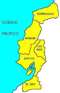
Guayaquil, Puerto Bolivar, Manta and Esmeraldas are ports of call along more than, 3,000 Km. of coast and beaches. It is an excellent area for fishing and water sports. There are five provices in this region: Esmeraldas, Manabí, Guayas, Los Rios and El Oro; each has different attraction and types of vegetation, ranging from rain forests tosemi-deserts and cloud forests.
In Esmeraldas, fishing villages basic attraction for visitors. Off shore, the waters are in shrimp, iysters, crabs, clams, lobsters and other crustaceans.
In the northern part of Esmeraldas province, we find the Awa Community´s Bio-Anthropological Reserve and Cotacachi-Cayapas Reserve2, typical of rain forest. These extremely humid areas support a complex, multi-specied plant community. The Chasis or Cayapas Indians, Blacks and Awa Indians live in the area, wich extends into Colombia and Ecuador.
The diversity of natural resources in Manabí makes the province especially appealing. Here you will find picturesque fishing villages, mangrove forests and salpepper beds, beaches, protected areas, island and lake environment and archeological sites.
Machalilla National Park3, covering an area of 55,100 H. including Salango and La Plata Islands, is certainly the centerpiece of this region. The park supports three life of this zones: moist forest, dry forest and very dry forest, all of wich provide a diversity of habitat for plant and animal species.
Guayas province has one of the country´s most important ecosystems, the Guayaquil Gulf, where the discharge of fresh water reaches 1,530 cubic m. per second to compromise 40% of the country´s continental shelf. There are six protected areas in the province, managed in distinct categories. The most important of these is the Churute Mangrove Ecological Reserve4 not far from Guayaquil-where a variety of mangrove species, dry forest, aquatic birds and associated fauna may be observed and atudied.
Due to the Humbolt Current, the south of the coastal landscape of El Oro Province is arid, supporting xerophytic vegetation. Banane are the major product of exportation. Plants have adapted to their arid surroundings, transforming their foliar organs into thorns and developing very deep root systems. In 1985, a new bird species was discovered here: the El Oro parakeet (Pyrrhua orcesi). El Oro´s semidesert are the site of the Puyango Petrified Forest5, one of paleontology´s most spectacular sites.
From Pasaje to Zaruma-Piñas, forests with numerous bird and orchid species abound. On the Pasaje Giron-Cuenca road there are excellent natural observation sites.
Sierra >>>>>
|