|
Español
|
|
Español
|
|
BY RECOVERING THE MEMORY OF ITS PAST |
| A new province and a new town
In mid-19th Century, Captain Ramón Tajonera, at the beginning of his mandate as Governor of the recently created province of Abra in Northern Philippines, was commissioned to explore the Cordillera Mountains for purposes of making the area accessible, of guaranteeing its security and governance, and of finding a viable route to travel from Ilocos to Cagayan. His reports, topographical studies and recommended plans contributed in an important measure to the development of the Province of Abra. The province was created by the Central Government of Spain in Manila with territory segregated from Ilocos. Tajonera was its first Provincial Governor and Bucay its first capital. The Province of Abra, made by a decree of the Superior Gobierno de Filipinas dated October 9, 1846, issued by Governor General Narciso Claveria y Zaldua, was composed of the 2nd and 3rd Divisions of Igorrots. The decree says Among the powers granted the Governor were the tax and especial tobacco collections. Tobacco was a monopoly of the Government controlling all its all trade and transactions that were subjected to special duties. Before 1846, Bucay was an old Tinguian settlement with a parish run by the Augustinians. It had a very strategic position on the left bank of the very wide Abra River, near the top of a promontory on which stood Fort General Martinez built some decades earlier. The town that rose near the fort could then be defended from possible incursions by Tinguian/Igorrot tribesmen from the mountains across the river and its location allowed to exercise effectively the monopoly control of tobacco produce moving through the river. The reasons for making of Bucay the capital of the new province are outlined in Claverias's decree creating the province of Abra with Bucay as capital. They had to do with Claveria's awareness, shared by Tajonera, of the area's very high strategic value. The decree further reads: "(convencido ... de la necesidad...) de estender nuestra dominacion hacia la Cordillera, para asegurar la tranquilidad de los pueblos reducidos, dificultar el contrabando, aprovechar en beneficio de la Hacienda, el tabaco que producen aquellos montes, y fomentar las demas producciones de que son capaces aquellos escelentes terrenos" "(convinced of the necessity) to expand our dominion towards the Cordillera, and with the purpose of ensuring the tranquility of the assimilated villages, of making contraband difficult, of turning to the benefit of the treasury the tobacco that the mountains produce, and of encouraging the production of other crops that the soil of those excellent lands make possible " In contempoprary terms, to expand the government dominion over the Cordillera by creating the conditions of peace and order and by building the industries and infrastructure that would foster economic development and welfare through the region. In doing so Claveria expected also to earn a substantial amount of government revenue. Bucay would play a pivotal role in the execution of these strategic goals. The seriousness of the government thrust was highlighted by the seemingly anomalous choice of Bucay as provincial capital. In normal practice, an existing town of some substance would be choosen as the capital of a newly erected province. In the case of Abra, common wisdom would have dictated to fix the capital in Bangued, a large prosperous town not too far from Bucay further down the Abra River. Common wisdom was discarded and a Tinguian ranchería was chosen instead to be the capital. The goals of pacification and development were taken so seriously that the capital was made of and into a frontier outpost, using as anchor the existing Fort General Martinez near the ranchería and converting it into the center of political and military operations to achieve the objectives for which the province and the capital were created. It is important to emphasize that Bucay was made to function, at least as much as a provincial capital, as the base from which to launch the enterprise of spreading the faith and expand the government spheres, they could not but go hand in hand, to the northern Cordillera and of assimilating the peoples therein into the main stream of XIX-century Philippines. This pivotal function was the main reason why Bucay became the Capital of Abra. Why else make that decision when there were more organized towns and at least one, Bangued, much larger and with more resources than Bucay? Tajonera's town Tajonera was the city planner of Bucay as we know it today. His plan shows that he wanted to make of the town a fitting Provincial Capital with political and military control over the province. The plan for Bucay was patterned after the old cuadricula system (streets laid at right angles to each other) with a town center where the buildings of the institutions would be erected. This way of planning cities was established for the Indies in an ordinance of Carlos V (1523) expanded by his son Felipe II fifty years later. It was an old plan but very rational, regulating land appropriation and use and laying an efficient infrastructure with different types of roadways.
In 1848, only two years after the creation of the Province of Abra and the establishment of Bucay as its capital, a map of the capital was drawn, found now in the National Archives, representing the town as actually built except for a few details on the northern end along the road leading to Tayum and Bangued.
The map, a beautiful work of art delicately restored and mounted, is some 4 feet wide. Above is a photo on which I superimposed a few captions in red for easy understanding. A digital drawing with captions of the fort and plaza can be seen in Fort Gen. Martinez Digital Map. Although the photo's resolution does not allow to read it, a list of street names appears in the legend right of the map. The street names have been forgotten to the point that nobody in town recognizes today any street name. Bucay is a town that lost its street names...! The plan's most prominet feature is a drawing in detail the of the fort that is given no name although it was known at the time as Fuerte General Martínez. A more detailed article on the Fort and Casa Real (click link) shows how Tajonera had to set his Casa Real or provincial goverment within the fort's facilities out of necessity. Economic realities of the times made him settle for remodeling the fort's officers' quarters to accommodate the functions of a Casa Real. The town planned by Tajonera included an outstanding feature that survives intact until our days, and that is the clear demarcation of institutional and residential areas, and of productive agricultural lots. He designed spaces for agricultural lands in their natural place: near the rivers and in the lower areas, leaving the modest heights of Bucay, cooler for the trees and altitude, as residential and institutional areas. I have always wondered why most of the so called development to the south of Manila since the sixties has chosen the low lands to subdivide and build, lands that were very often planted to rice, when there are higher grounds just a few kilometers to the west that are not suitable for rice fields and could be the site of handsome, not to mention cooler, villages. It is as if one did not need food anymore once he had a house ! After studying Bucay now, I wonder why this simple common sense approach was possible in XIX-century Abra and not applied in XX-century Metro Manila after more than a hundred years of theoretical advances in urban planning. Redefining Fuerte General Martinez as a political and military base of operations; adherence to the old norms for planning and building towns in the cuadricula or grid system adapted to the lay of the land; and an understanding of the needs and conveniences of the new town, guided Governor Tajonera in the tasks of designing an open town plan for his cabecera and executing it. Besides a detailed plan of the fort, the map's only other
public buildings are a Church that today is in a different place, and a
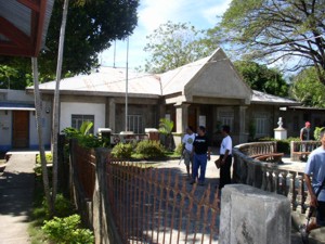
tribunal building that is still the Town Hall today although it lacks the
upper floor. The
Tribunals old mortar and brick building was damaged
by an earthquake in the early 1990s. As a result, the top floor was removed
and the front was covered with concrete and given a new look, but one can
still see under the roof and at the back of the building the old brickwork
with architectural elements around its window frames. The back of the building
is on the same street as the forts entrance arch and very near to it.
One of our elder relatives corroborated that she had heard from her father that the Church was moved across the street in early years of the XX Century; its area and the Tribunal are now part of the town square. Bucay no more Abra's capital The oblivion that befell Bucay --how many Filipinos know there is a Bucay or where it is? -- is partly due to the fact that the provincial capital of Abra was transferred from Bucay to Bangued. On June 27, 1863 three Gobernadorcillos (town mayors) of Abra signed a petition to the government requesting to transfer the Capital from Bucay to Bangued. The petition was signed by Julian Manzano of Bangued, Teodoro Belmonte of Tayum and Domingo Lalin de Cariño of La Paz. The reasons for the petition were that the frequent trips they had to do to Bucay to supply the cabecera, transact at the court, etc. were prejudicial and uncomfortable and Bangued was the oldest town anyway. Their petition was granted on July of the same year and that was the end of Bucay as Capital of Abra. A more detailed account of the transfer of the provincial capital head from Bucay to Bangued can be read in the above-referred study on Casa Real de Bucay. Bucay today is a beautiful sleepy town (see photo album) with a population that lives under the same town design as set by Governor Tajonera but seems to have lost the memory or meaning of its past and the strong will to surge ahead, like the waters of the mighty Abra River in the rainy season. I wonder if there is today anybody in town who can recall what happened to the Casa Real, or who knows its fate from the stories of their ancestors. I also wonder why the town lost its street names. The fort may have been destroyed during the Fil-American war at the beginning of the 20th century, or may have been abandoned, cannibalized and left to rot. Before more of the collective memory of Bucay is lost, it behooves the local executives to move actively to recover as much as possible of its historical identity. This endeavor will in turn contribute to recover the traditional looks of the town and will give its citizens a sense of connection with their past, of renewed belonging and of pride. Eventually it will generate interest in visitors and create a good environment for the local economy to develop. Bucay has a powerful metaphor of
what it was in the magnificent arch of its Casa Real. Its restoration
and the rehabilitation of the present wasteland within the ghost perimeter
of the old fort stockade are musts to help turning the town into a vibrant
community that is aware and proud of its past and therefore confident of
its future. The task only needs some planning, some resources but above
all political will.
|
| If you don't see the menu at left,
click on our |