|
Sultanate of Oman occupies the South-Eastern corner of the Arabian Peninsula and is located between Latitudes 16o 40’and 26o 20’ North and Longitudes 51o 50’ and 59o 40’ East. The coastline extends 1,700 kilometers from the Strait of Hormuz in the North to the borders of the Republic of Yemen and overlooks three seas – the Arabian Gulf, Gulf of Oman and the Arabian sea.
The Sultanate of Oman borders Saudi Arabia and the United Arab Emirates in the West; the Republic of Yemen in the South; the Strait of Hormuz in the North and the Arabian Sea in the East. The total land area is approximately 312,500 sq. kms. And it is the third largest country in the Arabian Peninsula.
Topography
The Sultanate of Oman has a variety of topographical features consisting of plains, wadis and mountains. The most important area is the coastal plain which represents about 3% of the total land area. The mountain ranges occupy about 15%. The Hajar range runs from Musandam in the North to Ras al-Hadd, the extreme limit of the Arabian Peninsula. In the South, the Qara range attracts the monsoon, which brings unique weather conditions and creates a special environment in Dhofar. The remaining area which occupies 82% of the country is mainly sand and gravel desert and includes part of the Empty Quarter.
Climate
The climate differs from one area to another. It is hot and humid in the coastal areas in summer; while it is hot and dry in the Interior with the exception of the higher mountains, which enjoy a moderate climate throughout the year. Rainfall is generally light and irregular; although heavy rains and thunderstorms can cause severs flooding. In the South the Dhofar region has a moderate climate and the pattern of rainfall is more predictable with heavy monsoon rains occurring regularly between May and September.
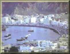
Muscat
The Capital area now extends from the town of Seeb in the North
to the fishing port of Quriyat in the South. With its commercial
centres, industrial areas, Government offices, foreign embassies and
hotels, the Governorate of Muscat is the most densely populated and
developed part of Oman. Al-Batinah
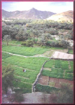
The Batinah is the area between the sea and the mountains running
some 270 kilometers from the border with the UAE to Muscat.
Traditionally it was a fishing and farming region. But is now becoming
more commercial and industrialised. In line with the policy of
diversification of the economy, with projects embracing a wide variety
of enterprises, many of which are located in designated industrial
areas. It is one of the most densely populated areas of Oman.
Behind the Batinah stretch the Western Hajar mountains running
parallel to the coast with the highest peaks reaching over 3000 meters.
The principal town is al-Rustaq which was once the capital of Oman. Al-Jauf
The al-jauf central plateau that stretches from the foot of the
jebel al-Akhdar South to the desert is the heartland of Oman and
contains historic towns of Nizwa, Bahla. Manah, Adam and Izki. Sumail
Gap
The Wadi Sumail forms a natural break between the Eastern and
Western Hajar mountain range and thus forms the main artery of
communication from the coast to the interior. The oil and gas pipelines
run through the Gap, in which there are many small settlements as well
as the major centres at Sumail, Bidbid and Fanjah. Al-Dhahirah
The Dhahirah, meaning the ‘back’ as opposed to the Batinah or
‘belly’ of the mountain is a semi-desert plain sloping down from the
Western Hajar towards the Empty Quarter. In the North it meets the UAE
at the border town of al-Buraimi. The other main towns are Ibri, Dhank
and Yanqul. Al-Sharqiya
The Sharqiya is an area of sandy plains and wadis lying on the
inland side of the Eastern Hajar mountain range. The main centres of
population are ibra and Sur. To the South lies the Wahiba sand sea and
along the coast small fishing communities and the islands of Masirah and
Mahawt. Al-Wusta
The central region is a gravel desert with escarpments running
down to the coast, where the main occupation is fishing. Inland lie
Oman’s oil and gas and mineral deposits. It also contains the Oryx
nature reserve. The main settlements are at Haima and al-Duqm. Southern
Region (Dhofar) The Southern region occupies about one third of the total area of Oman. The main town is Salalah which lies on the fertile coastal plain and the principal occupations of the inhabits are fishing and agriculture. Rusut, to the West of Salalah, is Oman’s second port and is also the location for a new industrial area. The Qara mountain range with its unique climate provides valuable pasture for cattle, camels and goats Offshore, the Halaniyat Islands support a small fishing community. Musandam
Separated from by part of the United Arab Emirates, Musandam is a
spectacular feature with mountains rising up to 1,800 metres and falling
precipitately into the sea. Once forming an almost impenetrable barrier
it is now being linked with the rest of Oman by a modern road network.
The main centres are Khasab and Bukha and the major commercial activity
is fishing. |

![]()