from What Life was Like When Longships Sailed, by the editors of Time-Life Books (Alexandria, Va., 1978).
In the illustration below, Farthingstone (or Farthegn's Tun) is located in the yellow-shaded area in the center of the map on the left side of the blue line.Ā Try as he might, King Alfred could not stop Viking settlements from spilling over to the west of Watling Street.Ā Today a few Scandinavian place-names, including Farthingstone,Ā are still found in this area.
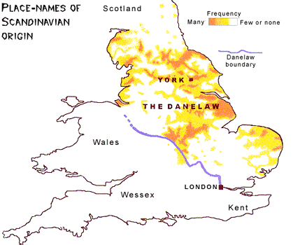
But Alfred escaped and won a temporary peace with his old foe.Ā He could not, however, stop theĀ mass immigration of Scandinavians to the Danelaw and they would eventually make it the most populous and prosperous region in the British Isles.ĀĀĀ
Previous Page......Next Page