 |
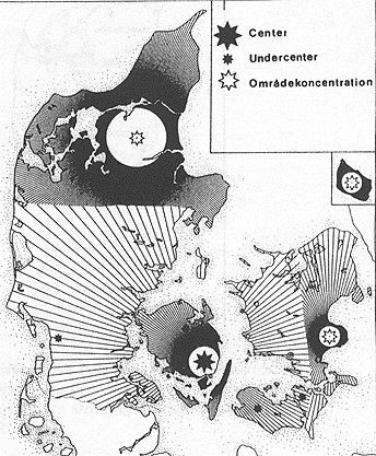
| The Anglian Power Center In the first few centuries of our era numerous tribes located in what is now Denmark aggregated into larger confederations. This eventually led to the formation of just three powerful tribes: the Jutes, the Angles, and the Danes. The map below, created by Eliza Fonnesbech-Sandberg, very clearly shows the area dominated by the Angles to be larger than the Jutish area in northern Jutland or the Danish area to the east. The Anglian power center was located on the island of Funen (or Fyn) in the settlement known as Gudme. Fonnesbech-Sandberg argues that the town of Gudme was the only center of power in the Migration period and that the rest of present-day Denmark is to be seen as a periphery to Gudme. Gudme lies only 5 kilometers from the coast. There, a port site known as Lundeborg, has produced further rich finds of Roman imports and Migration-period metalwork, including one of the largest gold hoards ever recorded in Denmark. The Gudme and Lundeborg complex was able to attract portable wealth in great quantity and redistribute it widely in the western Baltic region. Only after the Jutes and Angles migrated to Britain did the Danes become the politically dominant force in the region in the late sixth and seventh century. Please scroll down for this unusual and fascinating map. Previous Page......Next Page |