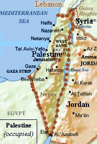
Palestine, currently under occupation, is located on the East coast of the Miditerannean Sea, West of Jordan and to the south of Lebanon. The territory of Palestine covers around 10,435 square miles (almost same size as the state of Vermont in the USA - that is, pretty small.) [1]
Out of this territory, there are 10,163 square miles of land area. The rest is water: half of the area of the Dead Sea (al-BaHr al-Mayyit), Huleh Lake (BuHayrat al-Huuleh) which was dried by the occupation and Tiberias Lake (BuHayrat Tabariyyah) which is also known as the Sea of Galilee (BaHr al-jaliil).
Topography and Terrain:
Palestine can be divided into four main distinct regions:
- Coastal and Inner Plains:
These are among the best fertile land in Palestine and elsewhere, with adequate resources of irrigation (from rainfall and underground water). They are where most of the Palestinian citrus groves used to stand. The coastal stretch is divided by Jabal al-Karmel (Mount Carmel) into the plain of Akka (Acre) and the plain of Palestine (also called Saruunah). The inner part consists, largely, of Marj bin 3aamir. This one is triangular in shape, with Jenin and Nazareth (An-NaaSirah) as its base and the SE edge of the Akka plain as its sharp corner. - The Mountains and Hills:
This part is largely rocky but has terraces which make it suitable for a number of trees. Olives is one of the most planted trees in these regions. There are almonds, apples and others. Also, there are patches of plains scattered around in this region and these are fully utilized: they are planted wheat, barely, lentils .. in Winter and vegetables during the Summer (mostly tomatoes, melons, maize and other vegetation that stands the hot weather). Mountains are located in al-Jaliil (Galilee), al-Karmel, Nablus and Hebron areas. - The Jordan Valley and Ghawr:
This is well below sea level, hence the name ghawr, with very good soil but very little water resources. Agriculture there depends on irrigation either from local streams or the Jordan River. Due to its climate, that region used to produce summer vegetables in late Winter stretching the availability of fresh produce before electricity and refregerators. The two lakes are at the northern edge of this region. - The Southern Desert:
This region comprises almost half of the land of Palestine. It is also triangular in shape. The base is fertile and the rest, with its apex near the town of Aqaba, is poor with scattered patches of regions suitable for cultivation. Bi'r as-Sab' (renamed Beersheba by the occupation) is the main town in that region.[2]
Population:
There has never been an accurate official census in
Palestine since the roots of the recent aggression.
Hadawi states that at the end of 1918 (WW1), there were
700,000 people living in Palestine. These were divided
into 574,000 Muslims, 70,000 Christians and 56,000 Jews.
Almost all the Palestinian Christians are Arabs and most
of the Jews as well (up to around 1900 AD). These numbers
check positively with the estimate that only 6% to 7% of
the total Palestinian population was Jewish right after
the first Zionist congress in Basel. It is also
consistent with what David Newman's statement [3] that: between 1800 and 1945, The
Jewish Population of Palestine increased from
approximately 25,000 to 600,000, eventually comprising
some 33 per cent of the country's population.