 With excess leave to burn off before the end of March I decided to take Thursday and Friday off
before the cold flame rally too explore some of the areas recently burnt.
The thought was to see some of the fire damaged alpine areas.
With excess leave to burn off before the end of March I decided to take Thursday and Friday off
before the cold flame rally too explore some of the areas recently burnt.
The thought was to see some of the fire damaged alpine areas.
So I left late as usual 10 am went to see Laurie Alderton about a frame modification I want done and talked mods, bikes and other things. Left about 11, lunch at one of those memorable (NOT) highway places. Then stopped in Mittagong to see Staintune about a quieter muffler - nup the muffler does not fit (too long)
 so that is out - looks like Wolf Mufflers will get my business. I left by Wombeyan Caves - no fire damage here
but things are very dry, not a touch of moisture in any of the crossings. On to Gundagai for over night at the
pub (Criterion I think). It had a pool night on and I looked at the other pub - no accommodation, an ex-pub has
been converted into a back packers … not for me though, too trendy from the look of it.
The pub cost $30 with continental breakfast and a complimentary drink - Tooyhes Old for me thanks.
The end of the fruit-picking season sees a few other strangers in the pub that night.
so that is out - looks like Wolf Mufflers will get my business. I left by Wombeyan Caves - no fire damage here
but things are very dry, not a touch of moisture in any of the crossings. On to Gundagai for over night at the
pub (Criterion I think). It had a pool night on and I looked at the other pub - no accommodation, an ex-pub has
been converted into a back packers … not for me though, too trendy from the look of it.
The pub cost $30 with continental breakfast and a complimentary drink - Tooyhes Old for me thanks.
The end of the fruit-picking season sees a few other strangers in the pub that night.

The next day I stopped in Tumut to ask about viewing the fire damage, they recommended going through Kiandra. So I went that way - yep damage but only on the southern side, if you scan left to right you could see what it should be like, road, then left to what the fire had done.
 The Yarrangobilly campsite (Alpine Rally site) has the
trees on the slopes around the southern part burnt, but it has not crossed the creek. Past Yarrangobilly the low
scrub has burnt the small shrubs are now a black set of sticks but the lower grass is green. May be the grass has
grown back already?
The Yarrangobilly campsite (Alpine Rally site) has the
trees on the slopes around the southern part burnt, but it has not crossed the creek. Past Yarrangobilly the low
scrub has burnt the small shrubs are now a black set of sticks but the lower grass is green. May be the grass has
grown back already?
 Going up to Cabramurra I was trying to remember the same scenes with snow and green instead of
the black and brown I was looking at.
Going up to Cabramurra I was trying to remember the same scenes with snow and green instead of
the black and brown I was looking at.

I think it is going to be very spectacular this winter. The road through to Kancoban was closed, so I used the Elliot Way - again very spectacular with black and brown views until you get on to the flat.
On to Corryong where I had lunch, got some RACV maps and asked about the road I wanted to use. "Closed" said the RACV man, "so is the Omeo Hwy, you'll have to go further south and come in through Mt Beauty." Bugger. Well there is no alternative so I travel south … pass the road I want to use to Benambra. No sign of closure; some signs for closing the road for snow and ice but nothing else… I take the road I wanted to take. I stop a local walking towards me and ask "Is the road open?" "Yes, the barriers are down and my son has been using it." Always ask a local, and if you don't like the answer don't be afraid of asking another local.
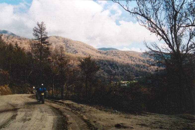
 As you approach the hills you can see the damage.
But the mind-blowing thing is that this hot burn continues
for over 50 kms.
As you approach the hills you can see the damage.
But the mind-blowing thing is that this hot burn continues
for over 50 kms.
 A sign about 7 metres clear of the vegetation has the reflective lettering melted off it!
This is a good road, but timber jinkers use it so there was dust on it - some about 70 mm thick. Arrived at
Benambra and there is the sign for Black Mountain, a road I want to use tomorrow. Some guys are crossing the
road to the pub; I stop and ask "Is the road to Black Mountain open? "
"Yes … is that an automatic?" "No"
I don't explain the 3 cylinder has a good rev range and I'm lazy with the gear change.
On to Omeo - still has the Fire Refuge sign up, not much sign of damage compared to Cabramurra -
the fire got real close there. Onto Swifts Creek. The Albion hotel has no accommodation,
but they have 2 units up the road - $30 a single in the no TV one does me ($10 extra for the TV).
$15 for chicken pama in the pub - should have dad the wood smoke fired pizza from the bakery - next
time! Always leave something for next time. Lightning flashes, as I go to bed- not a good sign.
A sign about 7 metres clear of the vegetation has the reflective lettering melted off it!
This is a good road, but timber jinkers use it so there was dust on it - some about 70 mm thick. Arrived at
Benambra and there is the sign for Black Mountain, a road I want to use tomorrow. Some guys are crossing the
road to the pub; I stop and ask "Is the road to Black Mountain open? "
"Yes … is that an automatic?" "No"
I don't explain the 3 cylinder has a good rev range and I'm lazy with the gear change.
On to Omeo - still has the Fire Refuge sign up, not much sign of damage compared to Cabramurra -
the fire got real close there. Onto Swifts Creek. The Albion hotel has no accommodation,
but they have 2 units up the road - $30 a single in the no TV one does me ($10 extra for the TV).
$15 for chicken pama in the pub - should have dad the wood smoke fired pizza from the bakery - next
time! Always leave something for next time. Lightning flashes, as I go to bed- not a good sign.
 At 1.30 am I wake to rain on the roof. Wonder how much will fall on the dirt before I get there?
Up around 7 am, shower, breakfast, shop -$10 bottle of port for the alcohol required at a rally and
some muslie bars for tomorrow breakfast then pack and on back through Omeo, Benambra and then Limestone Road.
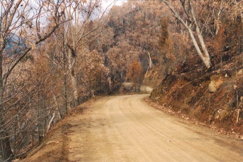
It turns to very good dirt with not much sign of lots of water. Signs of patch work fire damage.
Find a farmer leading some cattle in his 4wd with hay in the back. Asks me to stop and wait for them to pass,
as I've already stopped to talk it is fine but I forget to ask how much rain he's had.
At 1.30 am I wake to rain on the roof. Wonder how much will fall on the dirt before I get there?
Up around 7 am, shower, breakfast, shop -$10 bottle of port for the alcohol required at a rally and
some muslie bars for tomorrow breakfast then pack and on back through Omeo, Benambra and then Limestone Road.
It turns to very good dirt with not much sign of lots of water. Signs of patch work fire damage.
Find a farmer leading some cattle in his 4wd with hay in the back. Asks me to stop and wait for them to pass,
as I've already stopped to talk it is fine but I forget to ask how much rain he's had.
 The cattle pass,
some nervously, the tail end is another farmer in a 4wd pushing them on, I've forgotten all about the rain.
Onwards. Few 4wds coming the other way. They now have their headlight on - must be city types?
This is a pleasant road to travel on, ups and downs good scattering of scrub and trees, the fire damage
is variable and hard to work out why some bits are burnt to the trees tops other just the grass level is burnt.
Where fields appear most of the farmer's fields appear to have little damage. I start to climb, and a fog/low
cloud envelops me and the bike - now I put my headlight on and slow to 30 kms/h just to see the road, but it
clears just before the top of Wombat Range. Never thought I'd think about fog lights on this bike!
The cattle pass,
some nervously, the tail end is another farmer in a 4wd pushing them on, I've forgotten all about the rain.
Onwards. Few 4wds coming the other way. They now have their headlight on - must be city types?
This is a pleasant road to travel on, ups and downs good scattering of scrub and trees, the fire damage
is variable and hard to work out why some bits are burnt to the trees tops other just the grass level is burnt.
Where fields appear most of the farmer's fields appear to have little damage. I start to climb, and a fog/low
cloud envelops me and the bike - now I put my headlight on and slow to 30 kms/h just to see the road, but it
clears just before the top of Wombat Range. Never thought I'd think about fog lights on this bike!
 A large number of wallabies in pairs jumping around from time to time I'm surprised that they survived
the fires in such numbers. Down the other side and out to farmland on the Barry Way. I turn right, south to
Seldom Seen. Some vehicles here are ok … but most are burnt out. Just framework left of the old place.
A large number of wallabies in pairs jumping around from time to time I'm surprised that they survived
the fires in such numbers. Down the other side and out to farmland on the Barry Way. I turn right, south to
Seldom Seen. Some vehicles here are ok … but most are burnt out. Just framework left of the old place.
 Back to the north along the Barry Way. As I get to the climb the road becomes much worse - scattered rocks
across the road with some earth some of it on blind corners. My speed drops for a very slow trip.
Most things are burnt out; some is still green particularly down on the riverbank at one point.
When I get to it I see some has been burnt but is already regenerating so adding to the green.
I think that the other trees have not regenerated because they had not got enough moisture to do that;
the ones down near the river have access to more water. I round another corner to see the McArdles (Vic Club,
Chris & Sally) and Vince sitting at a table … so I stop expectation a request for a drive shaft,
clutch and other bits off my bike. Ahh they are just having lunch! We eat - then they tell me this
is the rally site (Willis) as the Pinch is closed and really burnt out.
Back to the north along the Barry Way. As I get to the climb the road becomes much worse - scattered rocks
across the road with some earth some of it on blind corners. My speed drops for a very slow trip.
Most things are burnt out; some is still green particularly down on the riverbank at one point.
When I get to it I see some has been burnt but is already regenerating so adding to the green.
I think that the other trees have not regenerated because they had not got enough moisture to do that;
the ones down near the river have access to more water. I round another corner to see the McArdles (Vic Club,
Chris & Sally) and Vince sitting at a table … so I stop expectation a request for a drive shaft,
clutch and other bits off my bike. Ahh they are just having lunch! We eat - then they tell me this
is the rally site (Willis) as the Pinch is closed and really burnt out. 


 Black clouds coming from the
North herald rain. So I put up my tent. Hal Caston (rally organizer) also does the same.
A large flash of light brings fort the comment "Speed Camera!" 3 seconds later comes the thunder,
umm my first guess is 3 kms away but that is wrong - sound travels around 300 metres per second so about
1 km for 3 seconds. Henning arrives from the South, but he is not staying having somewhere else to be tonight.
We all move fire wood to an agreed fire place, some of these bits require 6 people to move (drag), thank you
more arrivals! The SCUM tourers arrive with two 4wd support vehicles. Now they tell me there is a good patch of
mud down the road, and lots of muddy bits. I tell them of the track I come in on, Chris is most upset that
Black clouds coming from the
North herald rain. So I put up my tent. Hal Caston (rally organizer) also does the same.
A large flash of light brings fort the comment "Speed Camera!" 3 seconds later comes the thunder,
umm my first guess is 3 kms away but that is wrong - sound travels around 300 metres per second so about
1 km for 3 seconds. Henning arrives from the South, but he is not staying having somewhere else to be tonight.
We all move fire wood to an agreed fire place, some of these bits require 6 people to move (drag), thank you
more arrivals! The SCUM tourers arrive with two 4wd support vehicles. Now they tell me there is a good patch of
mud down the road, and lots of muddy bits. I tell them of the track I come in on, Chris is most upset that
I used the Limestone Road -"It is closed" nup - open I was told by the locals and a few others were using it and it is in better condition than this road. Vince then tells me that they had rain last night - lots of it in Jindabyne he says. Well that explains the rocks. The Canberra contingent of our club arrives. Chris asks about which roads are closed… I tell him that Cabrammura to Kankoban is closed. Don't know about Khancoban to Jindabyne. More arrivals. Someone asks, "What River is that?" Hal Caston answers "The Yarra- you can tell because it is flowing upside down" The river appears to be flowing from the South too. It is actually the Snowy River and has burnt black embers floating on top, dirty brown and black under that. OK for washing up but not for cooking and drinking. This catches some short. Moral - Carry Water. Some notable absences "They said they'd be here" Postman Pat, Al, Blue from Tumut (moving to Queensland and says this is his last southern rally). We talk most of the night - not real rain just some light bits when you can go for a pee and then get back for more talk. Vince reckons going from Canberra to Brindabella shows a fair amount of fire damage, so those going to the Alpine this year take note. Oh and cheese cake - thanks Sally (and Blue for asking for it). Bed.


The next day I go north a little later than some, the last thing I expect to see on a Sunday morning is a large yellow grader heading for me on the track but here it is, check sky for yellow destruction fleet; no. They have tidied up the boggy bits, thanks guys! The destruction on Jacobs Ladder is incredible. All is burnt. The trees are not very tall so I still think Corryong to Benambra would have been a much hotter fire. Just before the farmland begins the fire looks to have died out, why? On to Jindabyne and Cooma. Fill up and the back way to Braidwood for a light lunch and more dirt to Marulan. And back home via the Tar & showers - no need to wash the bike.
click on any thumb nail photo - should open another window with a 60k photo...
George Scarfes' photos from his trip You can e-mail me at Yahoo.