 |
Wanna Put up a question ? or
|
|
|
|
|
| PAKISTAN |
|
LAND AND RESOURCES
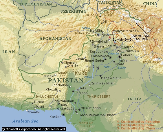
Pakistan is mostly a dry region characterized by great extremes of altitude
and temperature. Its topography is partly divided by the Indus River, which
enters the country in the northeast and flows south into the Arabian Sea. The
Indus forms in general the line of demarcation between the two main landforms of
the country, namely, the Indus Valley, which extends principally along the
eastern side of the river, and the Baluchistan Highlands, which lie to the west.
Three lesser landforms of Pakistan are the coastal plain, which is a narrow
strip of land bordering the Arabian Sea; the Khârân Basin, which is west of
the Baluchistan Highlands; and the Thar Desert, which straddles the border with
India in the southeast.
The Indus Valley in Pakistan varies in width from about 80 to 320 km (about 50
to 200 mi); from north to south it includes portions of two main regions,
namely, the Punjab Plain and the Sind Plain. The Punjab region is drained by the
Sutlej, Râvi, Chenâb, and Jhelum rivers, which are tributaries of the Indus;
these rivers supply the irrigation system that waters the Indus Valley.
The Baluchistan Highlands contain a series of mountain ranges; among these are
the Tobakakar Range, the Siâhân Range, the Sulaimân Range, and the Kîrthar
Range. The highest peak in the highlands is Tirich Mîr (7,690 m/25,230 ft)
located in the Hindu Kush mountains in the north. The Safed Koh is pierced by
the Khyber Pass on the Pakistan-Afghanistan border.
The highest peak in Pakistan is K2 (also known as Mount Godwin Austen). Rising
8,611 m (28,251 ft) above sea level in the Karakoram Range, the peak is located
in the region of Kashmîr that Pakistan controls. K2 is the second highest
mountain in the world, behind Mount Everest.
If u want to see a detailed map of Pakistan then click here!!