
Formation
of the Alps and Prehistory of Switzerland -
The
landscape of a country influences the economic and social development even in our modern
age. This is especially so for the confederation of cantons which have fused over
the past six hundred years into the central European nation-state of Switzerland.
From the map on the preceding page it can be seen that the cultural and linguistic borders
of the four surrounding states meet and mix in a complex way - the question for an
observer
is not so much how did it originate but rather how does it hold together under the
influence
of the powerful neighbors.
Before getting into this it would perhaps be interesting to describe how the
beautiful landscape of the present arose as a result of the geological forces which tore
central
Europe apart some 250 million years ago.
Geologists have documented that during the
Earths middle age there was a clustering
of the present continents in the region of present Europe. This huge landmass
was slowly
cut by an ocean (Tetyssee) in an East-West direction as the Atlantic opened (in
a North-
South direction) and the present continents began their long ride of some 200
million
years on the top of the molten core of our planet. This slow movement of a millimeters per
year is continuing today and will eventually once again result in collisions and fusing of
land masses in some future era. At the present time a similar trench is opening below the
Red
Sea and continuing up into Africa to form the Rift Valley and eventually a new ocean
will cut through east Africa.
As the defect in the earths crust continued to widen to some two thousand
kilometers and
deepen to several thousand meters, the elements of weathering were always at work on the
surrounding landmasses. The effects of wind and water were able to chemically and
mechanically erode and destroy the mountain ranges which we know were present on our
earlier continent.
During the somewhere around 100 million years of open ocean, the rivers on the surrounding
landmasses transported layers of mud, sand and gravel into the ocean depths and formed
compacted sediment layers several thousand meters in thickness. These processes are of
course, continuing in our present oceans and in some many millions of years to come, will
remodel the surface of the earth once again.

Ocean opening and deepening
About
100 million years ago the process of spreading was halted in the now Tethy
Ocean and the southern coast, ie. the African continent, began a northward movement.
As a result of this process - which is continuing to this day - the soft layers of ocean
sediment were compressed and folded as they were thrust slowly upwards.
The tremendous forces at work in the lower continental foundation caused the
Euro-
pean base to bend downward into the molten core and soften. The southern landmass
could then continue its northward movement over some one thousand kilometers. The
slow folding and pleating of the sediments as they rose up from the depths is believed
to have initially formed a series of long east-west chains of islands.

Ocean closing and folding soft sediments
The geology we see today is complicated by the fact that in the final stage as
the ocean disappeared, a large mass of material which was originally far to the south was
pressed
onto and over the deep ocean layers. This is why in some areas of the Alps you find
younger sediments overlaid by much older material. Also, as this was happening the
elements were at work weathering these soft materials at a high rate and filling, the what
had now become valleys, with deep weathered layers of mixed sediment compositions.
All during this time the present Altantic Ocean was continuing to widen as the
American
continent continued to drift westward. In this period there were large climatic changes
taking place as the ocean currents and wind flows were influenced by these changes in
the placement of the continents. This is well documented by the work done on the history
of the dinosaurers (Jura, Trias, etc.) who then ruled this subtropical world. Their
fossils
are found on each of these now far separated landmasses and show their development
took place on a common landmass, ie. before the breakup.
The present day view of the Alps is also complicated by the fact that in regions
where
there was early extensive weathering it was possible for the deep molten granite to
well up to the surface and mix with the sediments. In fact, in some valleys which have
been cut very deeply by rivers it is possible to now see crystalline rocks which were the
base of the original protocontinent which itself had a lifetime of some 400 million years
before splitting into the present pieces.
It must be remembered that the European Alps consist of material that was
transported
over a thousand kilometers northward. The formation of the Mediterranean See is a more
recent development and does not mark the northern shore of the African landmass.
Satellite photos clearly show the cresent shaped series of folds stretching from southern
France to eastern Austria of the mountains marking the collision with Africa. The same
mechanism shaped the Himalayan range where the Indian continent is moving northward
and pressing into and under the Asian landmass.

Folded sediments being covered by older layers
In a
later period, after the mountains had been formed, there was a final tremendous
push which deformed the earlier northern European shore region. Here a series of
low limestone mountains (Jura range, 1200-1600 m.) were created. These stretch from
near Paris to southern Germany and stretch along the northern border of Switzerland and
form the characteristic landscape of the Neuchatel region. The process of mountain
building continues to this day. Measurements in the road and railway tunnels show that
the Alps continue to rise somewhere between a millimeter and a centimeter per year.
This is held in balance overall by weathering effects. Also, there are many active seismic
areas under the mountains which show that stresses continue to be released along deep
fault lines.
The actual landscape we see today is a recent development - only some
two million
years old. This was the period where some five known ice ages have done so much to
remodel the region. The tremendous glaciers which flowed out of the mountain valleys
repeatedly covered all
of the Swiss plain and shoved the topsoil into the low rolling hills
seen today.
They scooped out the lakes and rounded off the limestone hills along the northern border.
The last glacier advance ended only "yesterday" - some 10,000 years ago in this
area
and left the large lake Neuchatel as a souvenir. The ice in this region reached some
1000 meters in depth and flowed out of the region behind Lake Geneva some 100 km.
to the south. Today large granite boulders are found scattered in the forests in
the
region. These were carried and pushed by the ice rivers which filled this part of the
western plain for some 80,000 years during the last ice age. From their composition
it has been possible to precisely determine the area where they began their journey.
As the last ice age ended it is believed
that the climate changed so rapidly that the
glaciers retreated back into the mountains in only some 200 to 300 years time.
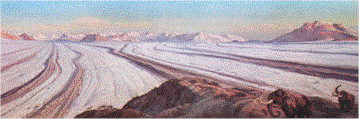
Twenty thousand years ago
Besides leaving an arcticlike wasteland of barren rock and gravel, the huge
morain
of material which was dropped at the front of the glaciers blocked the huge masses of
melt water which poured onto the central plain during this period. A huge lake resulted,
flooding our region to a depth of several hundred meters for many years. The old shore
line can be seen in some places along the low hills at
the foot of the mountains - the hills
actually being the side morains of the iceflow. As the Aare river, which now drains
western Switzerland into the Rhine river, eventually opened the natural dam the water
levels in the plain fell to near the present levels.
In the last 150 years man has changed the flow and levels of all the rivers
and most of
the extensive wetlands and small lakes have disappeared under the farmers plow.
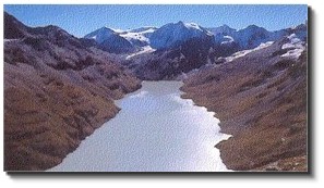
The view today
It is interesting to imagine what the early visitors to this area
experienced. It is known
that humans were in the area as long ago as the Old Stone age - at the beginning of
the last ice age - from artifacts found in several caves near Neuchatel. Certainly, bands
of hunters passed during the 80,000 years of arctic conditions and saw the huge rivers
of ice that covered everything except the tops of the mountains. It is necessary to go
into
the high mountains today to see similar conditions and today the remains of these mighty
rivers of ice are retreating so rapidly that it will only be a few more generations before
glaciers will exist only in books - or perhaps by then only on web pages.
Nature rapidly reclaimed the barren land and the tundralike conditions gave
way to
forests in only a few hundred years. The Neanderthal hunters were replaced by our
Homo Sapien forebearers and about
five thousand years ago colonization began in earnest
with the movement of the Celtic tribes throughout Europe and the beginning of Bronze
Age commerce.
But all that is a subject for the next section on the
history of the Switzerland -
|