FITCHBURG CUTOFF:
BELMONT, MASSACHUSETTS
-BIKE IT OR HIKE IT-
Planted:
NO LETTERBOX PLANTED AT THIS TIMELength: Currently 1 mile
Difficulty: Easy. Flat, stone-dust surface.
Directions:
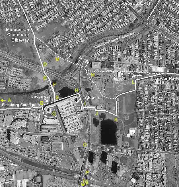
To start from Alewife T-Station; Take Boston's Red-Line to access this station. See; MBTA for more information. For information about taking your bike on the subway. See; MBTA/BIKES . From I-95, take exit 29 to Route 2 east to Alewife. Take the exit for Alewife Station Access Road and park at the T-station's parking garage.
The Fitchburg Cutoff Path was designated in the early 1990s by the MDC as a connection between Alewife Station and Brighton Street in Belmont along an old railroad bed. It's slated for an improvement project in the future and has been proposed as a link in the Mass Central Rail Trail, a 104 mile railroad line that once stretched from downtown Boston to Northampton, MA. See; MASS CENTRAL RAIL TRAIL and WAYSIDE RAIL TRAIL . For more information visit; FITCHBURG CUTOFF .
Alewife T-Station,
a stop on the commuter rail line into Boston is a hub for four trails that
radiate from it, as well as, another proposed future trail. From the northwest,
the Minuteman Trail terminates here.
See; Minuteman Bikeway Letterbox
. Head south for the Fresh Pond Trail.
See; Fresh
Pond Letterbox and
a future spur from Fresh Pond
that will connect to the Charles River
Bikeway called the Watertown Branch
Rail Trail. See; Watertown Branch
Rail Trail .West takes you along the Fitchburg
Cutoff, a short trail that is part of the larger Mass
Central Rail Trail and still a work in progress. East takes you along the Red
Line Linear Path which turns into the Somerville
Community Path, both of which are part of the larger Mass
Central Rail Trail. See; Somerville
Community Path . A proposed trail heading northeast called the Alewife
Brook Trail would connect to the Mystic
River and the Mystic River Paths.
See; Mystic River Paths .
From the end of the Minuteman Trail at Alewife T-Station,
Turn right and cross the Alewife Station Access Road, then turn left alongside this. You'll see an old sign for where the trail used to start on your right. However, a bridge is out so to reach the trail continue straight past the parking garage entrance ramp and you'll come to another parking garage. Between these two structures, on your right, is the start of the trail. You'll also see a sign reading "MDC Alewife Reservation Belmont Center". The trail takes you around the back of the first parking garage and along an old railroad bed with a stone-dust surface. The trail is a bit overgrown and narrow, but very rideable. To your right behind the shrubbery is Alewife Brook which flows out of Little Pond. After 3/4 miles you come alongside some railroad tracks and then come to Brighton Street at a mile.HH
BEFORE YOU SET OUT BE SURE TO READ THE
WAIVER OF RESPONSIBILITY AND DISCLAIMER
BIKE IT OR HIKE IT LETTERBOXING