This Sierra Nevada Webring site is owned by rv-ing & camping in the sierra nevada.
[ Previous | Next | Random Site | List Sites ]
Hi, Welcome to my Outdoor's Page !
I'm an avid camper and blessed to spend all and every Summer (some years even longer) in the Sierra Nevada, fishing, hiking, mountainbiking, rowing (if you see a guy rowing in a aluminum "barge" on union valley reservoir, it's probably me), "hunting" mushrooms, harvesting elderberries in the fall, bird watching and lots more. To sum things up, I'm having a blast up there. In 2006 I had the great fortune of witnessing the Kokanee Salmon spawning at Union Valley Reservoir. "An event fit to be filmed and shown on National Geographic" a friend and co-witness mentioned. Just imagine watching a pair of Bald Eagle's mating dance on a crisp Spring day, or seeing them swooping down onto the water and catching a trout! My favorite birds of prey are the Ospreys. I've been lucky enough to observe - at a distance through binoculars - some pairs all Summer long, from the time they built or "remodeled" their nests, right upto the time of their chicks first flight.


Smokey is smoking ...
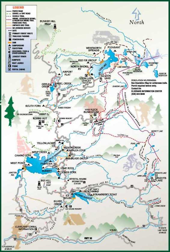
I'm particularly fond of the Crystal Basin Area, as you might have guessed, (Eldorado National Forest, Pacific Ranger District) which is located off US Hwy 50. (abt 11 miles E of Pollock Pines, take the Ice House Road turn-off and follow the signs) Before heading into the hills, it's a good idea to get the local N.F. map from the Eldorado N.F.'s Pacific Ranger Station, located off US50, or consult the SMUD issued overview map. It'll show you the locations of the various campgrounds. There are also a number of dispersed camping areas, some of them hidden away and others not far from the beaten path.
While you're up there, visit Robbs Resort.
Looking for a lightweight Camp Stove. The best one I came across and am still using after many years is the Sierra Stove. A very reliable, practical and trusted "friend" indeed. The original Manufacturers (ZZ Mfg Inc, Glendora, CA) have turned over their business to:
If you're planning to camp along the Eastern Sierra, check out Lundy Lake Resort, a reasonably priced and privately owned campground with hot showers and even a washing machine. The local store has most of the essentials, and the coffee is always free. The owners are really neat people. The turn-off is abt 5 miles N of Lee Vining, and then it's another 5 miles to the end of the paved road. You'll also see some campsites along the creek, which are operated by the County at higher rates than the ones charged by the Resort. (go figure ...) From there you can hike into Lundy Canyon which is absolutely gorgeous. You'll spot a ton of the most beautiful wildflowers and about half a dozen waterfalls along the way. If your game is visiting abandoned mining towns, then hike up to the May Lundy Mine along the Lake Oneida Trail which starts at the Lundy Lake Dam. Another great mining town is Bodie State Historic Park. It can get a bit crowded, but it'll give you a good idea of what everyday life might have been in those days.
Check out the locations of California National Forests: Click Here !