|
WELCOME TO AN GIANG
|
|
|
|
Area: 3,424 sq. km Population: 2,049,039 Provincial Capitals: Long Xuyen, Chau Doc |
|
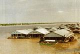
Districts: An Phu, Tan Chau, Phu Tan, Chau Phu, Thoai Son, Cho Moi, Tinh Bien, Chau Thanh, Tri Ton Economic potentialities: agriculture, fish breeding An Giang is located west of the Mekong Delta between the Tien Giang and Hau Giang Rivers and shares a 95-km border with Cambodia. It is next to the Cuu Long River and consists of a few midland areas and low mountains. The main ethnic groups found in the province are the Kinh, Khmer, Cham, and Hoa. The region is located in a monsoon tropical climate where the annual average temperature varies between 26 and 28°C. The two distinct seasons are the dry season, from December to April, and the rainy season, from May to November. Floods often occur from the middle of August to the middle of November. Famous sites and attractions include An Giang Museum in Long Xuyen, Ba Sam Temple Festival at Sam Mountain in Chau Doc, and Cam Mountain in Binh Tien. |
|