|
Ablepharus kitaibelii Bibron et Boty, 1833 |
|
 |
|
|
Last update: 19.09.2005. |
|
|
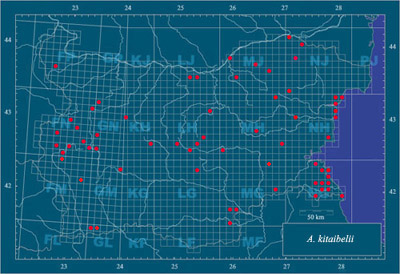
Notes. The exact described localities (including unpublished) cover 5, 04 % of the Bulgarian UTM-territory. Most of the localities are announced by ANGELOV et al. (1966), BARTOSIK et al. (1981), BESCHKOV (1961), BESHKOV (1998), BESHKOV & NANEV (2002), BISCHOFF (1969), BISERKOV (1987), BURESCH & ZONKOW (1933), NAUMOV (2005), NÖLLERT et al. (1986a), PESHEV et al. (2005), PETROV (2004), PETROV et al. (2001), STOEV (2000), TZANKOV (2005a) and UNJIAN (2000). There are some unpublished localities (in the personal data of the authors). |
|
|
Localities with undetermined UTM-codes: 1) Manda-Tash Place, Sakar Mts. – BURESCH & ZONKOW (1933); 2) Dam-Adasu Forest, Silistra District – BURESCH & ZONKOW (1933); 3) Karasarliyska kouriya Place, near Karnobat Town – BURESCH & ZONKOW (1933); 4) Karabouin Place, Rhododpes Mts. – BURESCH & ZONKOW (1933); 5) Stara reka Valley, Turgovishte District – UNJIAN (2000); 6) along Beli Lom River, Danube Plain – UNJIAN (2000). |
|
|
Altitudinal division of the localities: according to BESHKOV & NANEV (2002) up to 1100 m, but exact data deficient. |
|
|
References: see page Bibliography |
|
|
Special references: TZANKOV (2005a). |
|