|
Coronella austriaca Linnaeus, 1758 |
|
 |
|
|
Last update: 19.09.2005. |
|
|
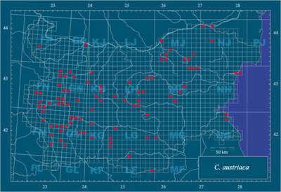
Notes. The exact described localities (including unpublished) cover 7, 12 % of the Bulgarian UTM-territory. Most of the localities are announced by BESCHKOV (1974), BESHKOV (1998), BESHKOV & DUSHKOV (1981), BURESCH & ZONKOW (1934), CYRÉN (1941), MIČEV (1968), NAUMOV (2005), PESHEV et al. (2005), PETROV et al. (2001), STOEV (2003), TULESCHKOV (1959), UNDJIAN (2000) and Vamporov (1973). There are many unpublished localities (in the personal data of the authors). |
|
|
Localities with undetermined UTM-codes: 1) Oulou Gidik Peak, Western Rhodopes Mts. – BURESCH & ZONKOW (1934); 2) Sokolets Mine, Stara Planina Mts. – BURESCH & ZONKOW (1934); 3) Teketo Place, near Rouse Town – UNDJIAN (2000). |
|
|
Altitudinal division of the localities: according to BESHKOV & NANEV (2002) up to 2200 m, but exact data deficient. |
|
|
References: see page Bibliography |
|