New Hampshire
Trip Report
Unique and magnificent are not words often
given to mountains in the Eastern United States, however, Mt.
Washington
is not only the most unique and magnificent mountain in the Eastern
U.S.,
but one of the most unique and magnificent in the entire country.
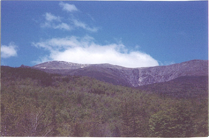
Mt. Washington is not a tree-covered peak, with a little bit above tree
line, rather it is similar to an alpine peak you would find in
Colorado.
When climbing, I felt like I was back on a 14er, except without the
altitude
screwing with my lungs. The hike itself is not too difficult, just
steep.
The views are tremendous and the weather can be extreme no matter when
you climb. While you can drive to the top, or take the train,
hikers
will cherish the experience of climbing to the top. Getting to
Mt.
Washington and the main Pinkham Notch trailhead, which offers a variety
of routes to the summit, is really easy. Just take route 16 in
Eastern
New Hampshire.

On May 30th, 2004, my friend Brian and I
climbed
Mt. Washington. We were planning on Tuckerman's Ravine, but when we got
to the start of steep hike, (about 2.4 miles in the trail) it appeared
closed. We went to the ranger station, and knocked on the desk. A dog
barked,
and a young man with a beard came out wearing overalls, to talk to us,
while his girlfriend was still getting up. It was only 7am. He said the
trail was closed due to a dangerous snow traverse, so I asked, "what
would
happen if we did try and climb?" He said. "oh, you'd die." Although he
amplified that it was just really risky, and maybe he was embellishing,
we took his advice, and headed back down the trail to climb from the
Lions
Head. The Lions Head trail, which is generally considered the short,
easy
trail, is not really class 1, but basically class 1 and class 2. In
some
cases, I chose to climb up the rock, instead of winding around the
trail,
which made my way class 2 for more of the trek. Mt. Washington's
weather
systems, in late May, give it the feel of a 14,000 foot peak, with a
lot
worse wind. The only difference is that you don't feel any altitude
effects,
and oxygen is still plentiful. We got up into apline country, and the
wind
was strong, about 40-50 mph. We hiked further, and noticed that clouds
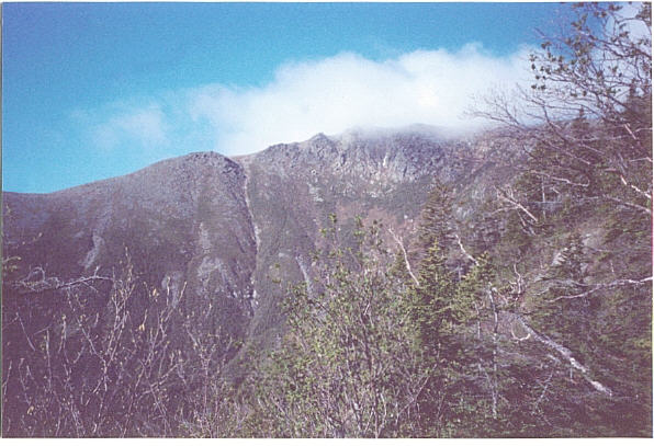
engulfed the summit. This did not prepare us for the experience we were
about to face, something as dangerous as I have ever climbed.
Visibility
was poor, so we cut up the slope, towards a higher rock cairn. The
weather
got worse, the wind faster, the air colder. The permafrost on the rock
vegetation was thicker and thicker, and the frost covered the rocks.
Frost
hit me in the face a couple times as I climbed higher, towards the
summit,
which I could not even see due to the wind clouds. Towards the summit
(which
I still did not know was less than 100 feet away) I was trying to
manuver
over the rocks, and I stood up, and a huge gust of wind knocked me
down.
I fell down on one rock, and then another, and then another, and landed
flat on my back. It was like falling down a flight of stairs, except
these
were rocks, not wood, and there certainly was no carpeting, except for
frost covered vegetation. I checked my legs, and I had hurt a muscle on
my left leg, but basically I was okay. I got up, and pushed forward. I
climbed the last rocks, and there was a flat surface. I looked up and
saw
what I thought was another 300 feet! Then I looked to the right and saw
a truck. I flagged him, and asked where I was. He said that I was at
the
summit. The summit was just around the road and up a small hill. I
waited
for Brian to make it up the rocks. Five minutes later he came up and we
got up to the summit. I still pulled my lower right calf on the way. A
ranger asked us to go to the shelter, but instead I walked up the last
15 feet or so to the summit. There was no way I would be denied the
summit
after all that climbing. We came into the shelter and I found out that
winds were 75 MPH and the wind chill was -4 degrees. A storm system had
engulfed the mountain for the last 2 hours, getting worse and worse,
and
peaking by the time we had gotten up there. Several climbers followed,
unwilling to be deterred from the summit, which, incidentally, is
precisely
the reason so many have died or been injured here. The weather does not
get bad until the last 1/3 of a mile, and those that have come so far,
say "it is just a little further" and that little further is what gets
them.
The clouds eventually subsided, giving
clear
views of the surrounding peaks. However, winds remained constant at 60
MPH, and it was still very cold, making photography difficult.
Highpoint
number 23 was complete, I headed down to open access day in Rhode
Island,
and made it 24. I got back to Arlington, Virginia at midnight, after
getting
dinner in my hometown of Greenwich Connecticut (which was on the way
home).
A long weekend, with too many tolls, but a lot accomplished.
![]()
![]()