WEST KAMENG DISTRICT
Compiled by S.N. Nandy
G.B. Pant Institute of Himalayan
Environment and Development, Kosi-Katarmal, Almora 263643, India
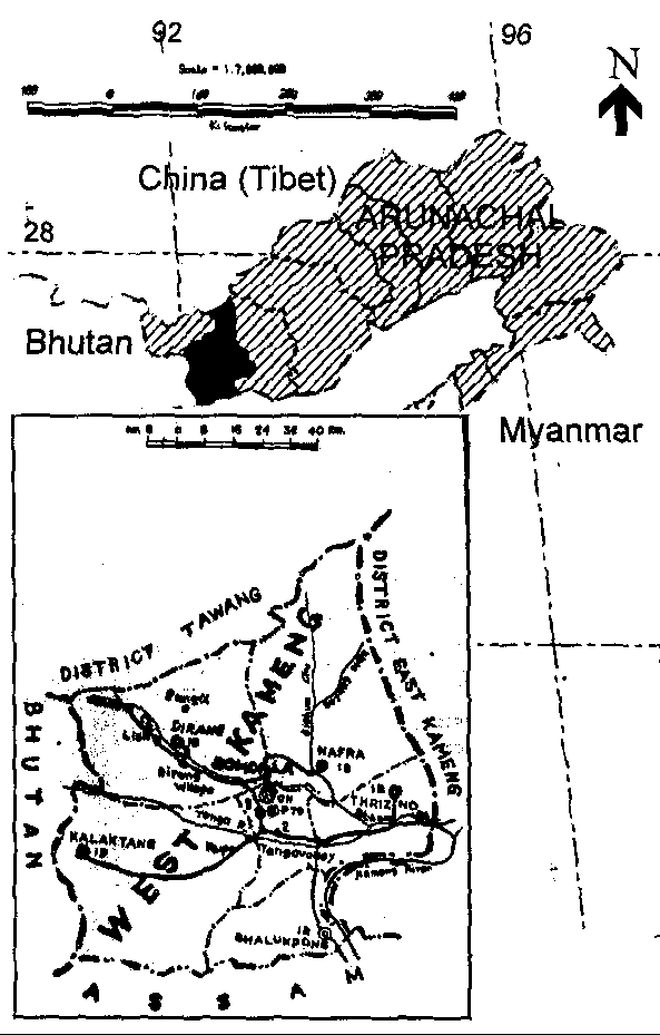
The West Kameng district is located in the western part of Arunachal Pradesh covering an area of 7422 km2 accounts for 8.86% of the total area of the state. Its main land extends between 91o30 to 92o40E longitudes and 26o54 to 28o01N latitudes. The district is surrounded by East Kameng district in the east. Its northern boundary passes through the high peaks of the Himalayas that form the boundary between India and China (Tibet). The western boundary of the district demarcates Bhutan from India. Tawang district lies in the north-west of the district while the southern boundary extend to Sonitpur district of Assam. The name of the district is derived from Kameng river, a tributary of the Brahmaputra, that flows through the district.
Location map: West Kameng, Arunachal Pradesh.
The topography of the district is mostly mountainous. A greater part of it falls within the higher mountain zone, consisting a mass of tangled peaks and valleys. In West Kameng there are three principal mountain chains - part of Sela range, Bomdila range and Chaku range. The Sela range consists a series of mountains arranged in the form of big line from Tibet in the north, Bhutan in the west and thus forming a tough terrain to pass through it. The altitude of Sela range varies from 14000 to 15000 feet and Sela pass is 13714 feet high. The Bomdila range having an average height of 9000 feet, South of Bomdila range lies the Chaku range (foot-hills range) having hills of quite low altitudes and is full of tropical forests with trees of great economic value and various types of wild game.
Tenga, Bichom and Dirang Chu are the main rivers flowing through the district. All these rivers are tributaries of the river Kameng which flows through Bhalukpong circle of the district and joins the river Brahmaputra in plains of Assam.
The inhabitants of the district comprises mainly of Monpa (Dirang, Boot, Lish, and Kalaktang monpa), Miji (Sajalong), Sherdukpen, Aka, and Bugun (Khawa). The Monpas belong to the Tibeto-Mongoloid stock and are the largest tribe of the district, inhabiting mainly in Dirang and Kalaktang circles. The Mijis are settled in Nafra and Akas in Thrizino circle. The Khawas inhabit in Wanghoo, Kaspi, Singchung and Tenga areas. The Seherdukpens are mainly settled in 4 villages of Rupa, Jigaon, Sergaon, Thongre and also in Doimara area. By and large the inhabitants are Buddhists though Akas, Khawas and Mijis believe in indigenous religion and follow partly Buddhist and Hindu practices. Every tribe has its own society and village council.
As per 1991 census, West Kameng district is having 170 villages with a population of 56,421 comprising of 30966 males and 25455 females. The district population accounts for 6.53% of total population of the state. The literate population of the district as per 1991 census is 20,585 forming 46.31% of total population comprising 55.03% of males and 35.22% of females (excluding the population of age group 0-6 years) and is higher than the literacy rate of the state (36.41%). The sex ratio (number of females per 1000 males) has decreased from 836 (1981 census) to 822 (1991 census) which is much less than the nations figure (927) and also lower than the states (859). However, the 1991 census recorded a higher sex ratio (970) among children of age group 0-7, indicates a positive ratio towards the future decades.
The district is divided into three administrative sub-divisions viz.
Bomdila, Nafra-Buragaon, and Rupa. All the circle head quarters of the
district are connected with the district head quarters (Bomdila) by roads.
Regular passenger services to Guwahati, Tezpur, Itanagar, Tawang and all
the circle head quarters of the district are being provided by State Transport
and private buses. Bhalukpong is the nearest railway station in the district
situated at about 100 km from the Bomdila, while Salonibari (Tezpur, Assam)
is the nearest airport about 160 km from the district head quarters.
| Amenities of the district (as on 31/3/98) | |
| Road length | 1339 km |
| Electrified village | 152 |
| Electricity installed
- Hydel - Diesel sets |
4480 kw 1269 kw |
| Craft centre | 2 |
| Forest
- Reserve forest - Forest Division |
1784 km2 4 |
| Area under irrigation channel | 1719 hect. |
| Cooperative societies | 31 |
| Rural Development
- IRDP beneficiaries - IRDP expenditure (Rs. in lakh) |
755 35.92 |
| Banks
- Nationalized (SBI) - Co-op. Apex Bank |
7 1 |
According to 1991 census out of total 170 villages 117 villages of the district have been electrified. The hydel project has the major share of the total installed capacity of electricity in the district with capacities of Dirang (2000kw), Sessa (1500kw), Rahung (750kw), Rupa (200kw), and Jigaon (30kw).
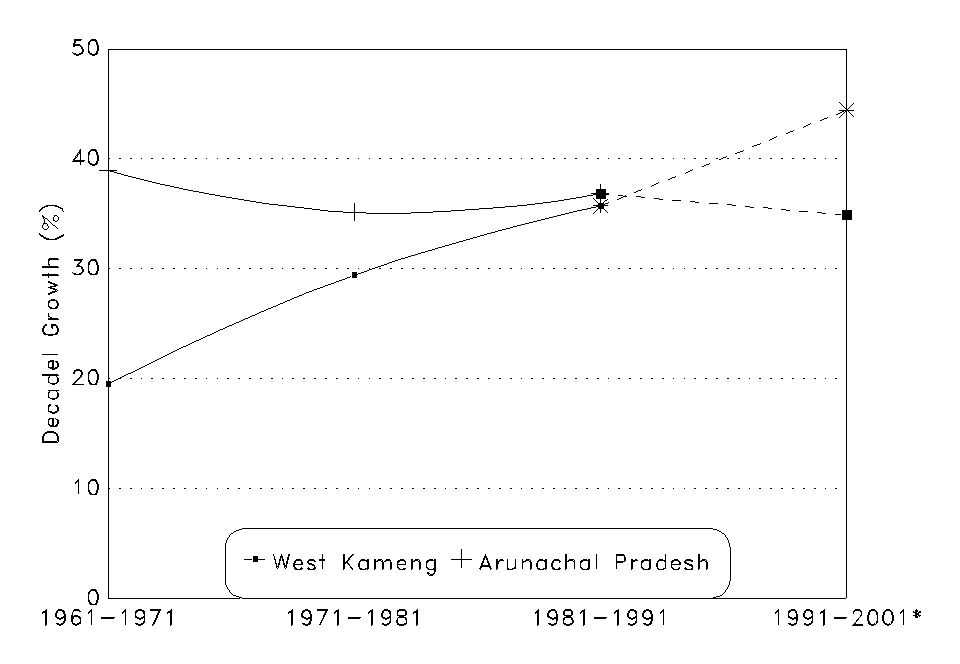
Decadel growth rate of West Kameng district as compared to the States
growth rate; *Projected figure
| Parameters |
1981
|
1991
|
Rate of change(%)
|
| Decadel growth |
29.15 [35.15]
(1971-81) |
35.73 [36.83]
(1981-91) |
+22.57 [+4.78]
|
| Density (persons/km2) |
7 [8]
|
8 [10]
|
+14.29 [+25.00]
|
| Sex ratio (females/1000 males) |
836 [862]
|
822 [859]
|
-1.67 [-0.35]
|
| Literacy rate* |
21.45 [20.09]
|
36.48 [28.72]
|
+70.07 [+42.96]
|
| Urban population |
9.29 [6.56]
|
10.02 [12.80]
|
+7.86 [+95.12]
|
| SC Population |
0.59 [0.5]
|
0.43 [0.47]
|
-27.12 [-6]
|
| ST Population |
55.58 [69.8]
|
52.99 [63.66]
|
-4.66 [-8.8]
|
| Main workers |
47.58
|
43.47 [39.34]
|
-8.64
|
* Includes population below 7 years age; Figure in [ ] represents the respective data of Arunachal Pradesh.
Block Level Data (as on 31/03/95)
| Blocks | Dirang
(Dirang circle) |
Kalaktang
(Kalaktang circle) |
Nafra-Buragaon
(Bomdila Sadar, Bhalukpong, Nafra, and Thrizino circles) |
| Head Quarters | Dirang | Kalaktang | Thrizino |
| No. of villages | 36 (18) | 49 (53) | 85 (85) |
| Population | 15531(12620) | 14079 (8206) | 26811 (20741) |
| Sex ratio | 844 (841) | 823 (824) | 808 (833) |
| Decadel growth rate (1981-91) | 23.07 | 71.57 | 29.27 |
Figures within ( ) represent the respective data of 1981 census.
Land utilization (in hect.) during the agricultural year 1994-95
| Name of blocks | Net sown area | Area under current fallow | Fallow land other than current fallow | Other cultivation land excluding fallow land | Cultivable waste land | Land not available for cultivation |
| Dirang | 2075 | 51 | 27 | 584 | - | 48 |
| Kalaktang | 2101 | 205 | 429 | 534 | 497 | 227 |
| Nafra-Buragaon | 2366 | 921 | 1148 | 865 | 726 | 619 |
| West Kameng | 6542 | 1177 | 1604 | 1983 | 1223 | 894 |
Area under major crops (in hect.) during the agricultural year 1994-95
| Name of blocks |
|
|
|
|
|
||
|
|
|
|
|||||
| Dirang |
|
|
|
|
|
|
|
| Kalaktang |
|
|
|
|
|
|
|
| Nafra-Buragaon* |
|
|
|
|
|
|
|
| West Kameng district |
|
|
|
|
|
|
|
* Data of Bhalukpong circle under Nafra-Buragaon block are not available
Area brought under fertilizer: 1225 ha; Area under HIV/improved: 631
ha; Area brought under plant protection: 2310 ha.
Horticulture farm/garden (as on 31/03/95)
| Name of blocks | Government farm | Horticulture nurseries | Peoples horticulture gardens |
| Dirang | 2 | 1 | 249 |
| Kalaktang | 1 | 1 | 280 |
| Nafra-Buragaon | - | 2 | 831 |
| Blocks | Dirang | Kalaktang | Nafra-Buragaon |
| No. of veterinary disp./aid centre/cattle upgrading centre | 13 | 11 | 16 |
| No. of villages electrified | 26 | 45 | 59 |
| No. of villages having drinking water supply facilities | 36 | 49 | 84 |
| Post & telegraph office | 6 | 4 | 9 |
| Schools
- Pre-primary - Primary - Middle - High - H.S. School - College - Central School - Private/Govt. Aided School - Technical Institution/Training Centre |
29 28 6 2 - - - 1 2 |
10 26 5 1 2 - 2 4 - |
22 42 6 3 1 1 1 1 1 |
| Medical units
- General Hospital - Primary Health Centre/Sub-centre - Homeopathic dispensary - T.B. Hospital/Leprosy clinic |
- 5 - - |
- 7 - - |
1 9 1 1 |
| No. of registered Small Scale Industries | 1 | 1 | 1 |
| No. of social and cultural organizations | 2 | 5 | 8 |
[Sources: Census of India 1991, Block Level Statistics 1995, West Kameng
District at a glance 1998, Brochure of West Kameng District, District Statistical
Office, Bomdila (Arunachal Pradesh), The Encyclopedic District Gazetteers
of India (Ed. S.C. Bhat)]
|
|
|
|
|