
HOW THE SUNGOD REACHED AMERICA
c.2500 BC
A Guide to Megalithic Sites
Dr. R.M. de Jonge
J.S. Wakefield
CHAPTER 4
THE DISCOVERY OF THE FAROES, ICELAND, AND GREENLAND
The Decipherment of Megalithic Picture Writing
(Petroglyphs of Cairn T, Loughcrew, Meath, Ireland, c.3200 BC)
Dr.R.M. de Jonge, drsrmdejonge@hotmail.com
J.S. Wakefield, jayswakefield@yahoo.com
-------------------------------------------------------------------------------------------------------------------------------------------------------------
FROM CHAPTER 4:
SUMMARY OF THE STORY OF LOUGHCREW, IRELAND
c.3300 BC
Dr.R.M. de Jonge, drsrmdejonge@hotmail.com
J.S. Wakefield, wakefield@worldnet.att.net
STONE C8, CAIRN T
This is a story in ideograms, a quantitative picture writing, actually the oldest written history on earth. It is a story of the attempts to reach the other side of the world, - that is, to cross the ocean (c.3300 BC). These images are a unique form of picture writing, and are the most historically important and most beautiful megalithic inscriptions in the British Isles. We consider them the second best in Europe, after the petroglyphs of Dissignac, Brittany. As in many other examples of cave and stone art, the natural shape of the stone has been used as part of the work, the surface of the stone being an endless sea that is now called the North Atlantic Ocean. As drawn in detail in Fig.1, note the coast of Europe on the right, Greenland in the north, and the other, unknown side of the ocean on the left. The proof of the story lies in the inscriptions themselves. Each figure represents a number. By adding the numbers, the actual and true degrees of latitude of the discovered land-points are obtained, and all in historical order!
STONE C8 (Figure 5)
A long time ago we travelled with a sailing boat (A) from the Strait of Gibraltar (A), via the Canary Islands (B) to Cape Verde (C) at 15
° N (A+B+C=6+6+3=15). We wanted to cross (D) the North Atlantic Ocean (the surface area of the stone) at the latitude of the Tropic of Cancer, at 23° N (A+B+C+D=6+6+3+8=23), in honor of the SunGod Ra (D), but we were not able to do so. However, from Cape Verde we discovered the Cape Verde Islands (C) at 15, 16, and 17° N (B+D+C1+C2+C3=6+8+1+1+1). But still we were not able to cross the Ocean.Later, we discovered from the Canary Islands (B), the two Islands of Madeira (E and F) at 33
° N (A-F=33). At about the same time we discovered from the British Isles (G), west of Scotland (G'), the islet of Rockall (G''), at 57° N (A-G+G'+G''=41+8+8=57). These islands gave a little bit hope (E is a little sun, and G'' is a star).Then, after some time we discovered from Madeira (E) the three island groups of the Azores (F, H, and I), at 37, 38, and 39
° N (Aa+Ab+B+E+F+H+I=1+1+1+36). These islands lie in the middle of the Ocean (H and I are glyphs of the ocean with latitude lines and lines in the middle of them). But still we were not able to cross the Ocean!Finally, we discovered from the Orkney's (J) at 59
° N (A-H+J=50+9=59) the Faroes (K) at 62° N (A-I+K=58+4=62), and from the Faroes we reached the SE coast of Iceland (L) at 64° N (A-I+L=58+6=64). The sailing distances are only 4dl= 4x111= 444km (G'a= G'b= 4dl). Iceland (L) lies like the Azores (H and I) in the middle of the Ocean (L resembles H and I).Thanks to the SunGod (M), we discovered from the NW peninsula of Iceland (L') at 66
° N (64+L'=64+2=66) Cape Holm (M) at the SE coast of Greenland, which lies on the Arctic Circle (M) at 67° N (A-I+M=58+9=67). The sailing distance is 5dl= 555km (the waves go up and down 5 times). Cape Holm (M) can be reached from Cape Raven (M'), at 69° N (67+M'=67+2=69), in the easiest way.From Cape Holm (M) we sailed 1
° (N=1) to the south to the Eric the Rode Islet (N) at 66° N (67-1=66). Next we went 7° (N+O+P=1+1+5=7) south of the Arctic Circle to Cape Farvel (P), the south cape of Greenland, at 60° N (67-7=60). From there we went 1° (O=1) to the north to the SW Cape (O) at 61° N (60+O=60+1=61). But at these places we gave up (P, the little man).
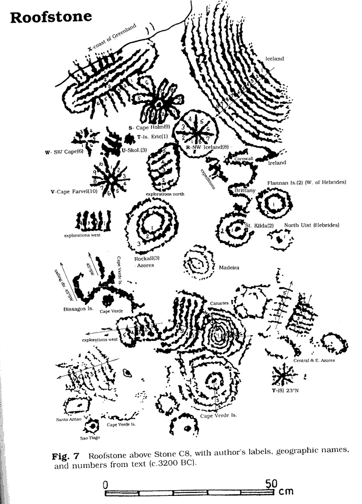
THE ROOFSTONE (Figure 7)
The top right side shows that the sea SW of Iceland has been explored over a distance of 10dl=1111 km. To the south, this is until the north coast of Ireland. Besides we see the coasts of Cornwall (above), and of Brittany (below).
From the megalithic center of Brittany we sailed directly to the NW peninsula of Iceland (R) at 66
° N (A-I+R=58+8=66), and next to Cape Holm (S) on Greenland at the Arctic Circle at 67° N (A-I+S=58+9=67). From there we sailed 1° (T=1) to the south to the Eric the Rode islet (T) at 66° N (67-1=66), and another 3° (U=3) to the south to Skjoldungen (U) at 63° N (66-3=63). Next we reached Cape Farvel (V), the southernmost point of Greenland, at 60° N (A-H+V=50+10=60). Finally, we arrived 6° (W=6) south of the Arctic Circle, at the SW Cape of Greenland at 61° N (67-6=61). The two lowest beams match the shape of the south coast of Greenland exactly! The upper edge of the stone represents the SE coast of Greenland. Inscription X has 3 distance lines and 6 beams at both sides, pointing towards the south of Greenland. This means that the coastal waters from 67° N to the SW Cape at 61° N (67-6=61) have been explored over 3dl=333km.Below the "peninsula of Brittany" are the Flannan Isles (2dl) with below it the west cape of North Uist (Hebrides, Scotland), then the islet of St. Kilda (2dl), and finally in the west the Islet of Rockall (3dl). Rockall is located at 57
° N (A-H+2+2+3=50+7=57). Around Rockall, the sea has been explored over 3dl=333km, which is the distance to St. Kilda, and to the north over an additional distance of 5dl=555km, which is till Iceland (R) at 65° N (57+3+5=65). To the west the ocean was explored over an extra 4dl=444km, which is a total of 7dl=777km (3+4=7).At the right bottom corner on the stone, a little star Y indicates the point where the Tropic of Cancer leaves the continent of Africa at 23
° N (A+B+C+Y=6+6+3+8=23). Here people wanted to cross the Ocean in honor of the SunGod, but they did not succeed in doing so!------------------------------------------------------------------------------------------------------------------
HOW THE SUNGOD REACHED AMERICA
c.2500 BC
A Guide to Megalithic Sites
384 pages, half of them photos, petroglyphs, groundplans and maps
Copyright 2002 MCS Inc.
ISBN: 0-917054-19-9
$24.95 US
Make sheck out to MCS Inc., Box 3392, Kirkland, Wa 98083-3392 (include $9 for Global Priority Mail or $5 for US Priority Mail, or $1 for CD version Airmail; permits a printed copy).
For bulk orders for resale call 1-877-513-0219, or email us at jayswakefield@yahoo.com
Availability in Europe, E 28.90: Frontier Bookshop Eerste Bloemdwarsstraat 15, 1016 KR Amsterdam, Tel: +31-(0)020-330-9151 Within Europe also via post order: http://www.fsf.nl/nfsf/shop/ -------------------------------------------------------------------------------- HOW THE SUNGOD REACHED AMERICA, c.2500 BC, will be discussed by Drs R.M. de Jonge at: THE FRONTIER SYMPOSIUM Hotel Krasnapolski AMSTERDAM November 9, 2003 10 am till 6 pm Website: http://www.fsf.nl Frontier Sciences Foundation Email: info@fsf.nl---------------------------------------------------------------------------------------------------------------------------------------------------------------------------------------