*Major Hurricanes - Virginia to Massachusetts
(1900 - 2007)
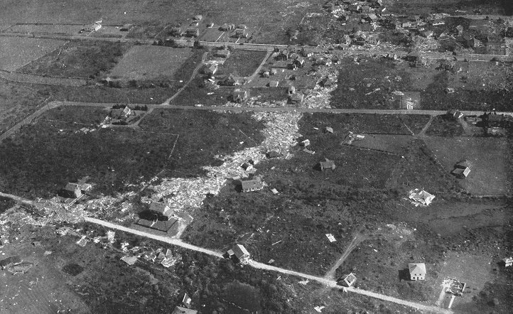
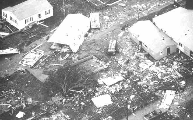
TOP: SOUTHEASTERN CONNECTICUT- A 12-foot storm-surge and wind gusts over 130-mph, leveled many communities like this one in Stonington, Connecticut during the 1938 Hurricane. More than 600 people were killed in this tropical cyclone (Photo courtesy CT Circle Magazine - 1939).
* Major Hurricane = sustained winds 111-mph or higher/pressure below 28.50 in (965 mb).
|
Storm |
Lowest
Pressure/
Sustained Winds @ |
Areas
Effected
|
Rank
|
|---|---|---|---|
|
27.94
(946
Mb)
- 120-Mph (est).
#
|
Rhode Island/New York/Connecticut. |
1
|
|
|
9/11/1954-EDNA
|
28.17
(954
Mb) -
110-Mph (est). #
|
Massachusetts.
|
2
|
|
28.35
(960 Mb) - 110-Mph. (est).
#
|
Rhode
Island/Connecticut/Massachusetts.
|
3
|
|
|
9/14/1944.
|
28.35
(960 Mb)- 100-Mph (est).
|
Virginia/Maryland/New
Jersey/New York/Connecticut/Rhode Island/Massachusetts.
|
3
|
|
9/12/1960-DONNA.
|
28.37
(961 Mb) - 100-Mph. #
|
Virginia/Maryland/Delaware/New Jersey/New York/Rhode Island/Connecticut/Mass |
4
|
|
28.37
(961 Mb) - 85-Mph. #
|
Virginia/Maryland/New
York /Connecticut.
|
5
|
|
|
28.40
(962 Mb) 105-Mph.
|
Rhode Island/Massachusetts.
|
6
|
|
|
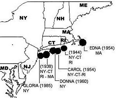
Map of major hurricanes to strike from Virginia to Massachusetts (1900- 2006). |
|||
Since 1900 six major hurricanes have made landfall between Virginia and Massachusetts. No major hurricanes have struck the Atlantic Coast north of southern Massachusetts. There is no record of a category 4 or 5 hurricane landfall in the north Atlantic states. Most of the major hurricanes to strike the northeast coast were moving at greater than 30-mph at landfall. Often, the combination of wind speed and forward motion - increases the destructive potential of the wind and ocean surge on the right hand side of the storm. This is a critical and especially dangerous aspect of hurricanes that strike this region. Eastern Long Island, eastern Connecticut, and Rhode Island have suffered very heavy wind and storm surge damages several times since 1900. The period from 1938 to 1960 were very active in the north Atlantic states - four major hurricanes struck in just 22 years. Since 1991 (Bob) - there has not been a hurricane landfall in the north Atlantic states.
Most of the major hurricanes to strike the north Atlantic states tend to approach along similar paths. Many of the hurricanes that strike the region originate from disturbances off the African west coast, or originate in the far eastern tropical Atlantic. Any hurricane that pass to the north of Puerto Rico, and to the east of the Bahamas, historically is a high risk to the upper Atlantic coast. At times, the forward speed of a hurricane increases as it moves northward along Atlantic coastline of the U.S. There seems to be a tendency for hurricanes to threaten the north Atlantic states when the Bermuda High is stronger and slightly farther north. When the subtropical high is in this position - a strong southerly flow often directs tropical cyclones northward toward the north Atlantic states.
Rarely will a landfalling tropical cyclone produce hurricane conditions in the large cities of the northeast (Richmond, Washington, Baltimore, Philadelphia, New York City). The large urban areas from Virginia to New York are generally west of the normal northeast path of hurricane movement. However - tropical storm conditions with high winds (40 to 73-mph), torrential rain, and severe inland flooding have occurred several times as tropical storms have passed over the northeast urban corridor. Hurricane Hazel (1954), Hurricane Diane (1955), Tropical Storm Agnes (1972), and Hurricane Floyd (1999) caused extensive flood damage in the urban northeast. Maryland, New Jersey, and Connecticut have experienced several flood disasters as tropical storms have passed over the region.
North of Cape Cod, Massachusetts, hurricanes usually weaken to tropical storm strengthen or loose tropical characteristics and become extratropical. Atlantic Ocean water temperatures from Massachusetts northward cool very quickly. Tropical cyclones swiftly lose intensity once the reach the ocean waters east of Massachusetts as they accelerate northward. Consequently, no major hurricanes have ever struck the Atlantic coast north of southern Cape Cod.
The physical geography of the north Atlantic states greatly influences where hurricane conditions are often experienced. Virginia, Maryland, Delaware, and New Jersey - are orientated north to south. These states are more likely to be brushed by hurricane conditions - than receive a direct hit. However, from Long Island, NY northeastward - the United States mainland protrudes into the Atlantic Ocean. Long Island, NY, Connecticut, Rhode Island, and the Cape and islands of southeastern Massachusetts lie directly in the path of northeast moving tropical cyclones. This shape of the mainland coast is the reason why hurricane and major hurricane risks are substantially higher in New York, Connecticut, and Rhode Island - than anywhere along the Atlantic seaboard north of Virginia Beach, VA.

HURRICANE RISK - Hurricane risk in the North Atlantic States is highest in New York, Connecticut, and Rhode Island, and Cape Cod, Massachusetts because they extended east into the Atlantic Ocean. Extreme southeast Virginia near Virginia Beach is often brushed with hurricane conditions as well.
TOP :Photo of Hurricane Alex, 300 - miles south of Long Island, NY with 120-mph winds in 2004 (NOAA).
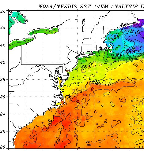
ABOVE: ATLANTIC OCEAN TEMPERATURES:
This midsummer sea surface analysis clearly illustrates the sharp differences in Atlantic Ocean temperatures between the New England/Canadian Maritimes region - and the middle Atlantic States. From Massachusetts northward - the Atlantic Ocean cools very quickly, while from Rhode Island south to Virginia - the Atlantic Ocean is much warmer (NEIDS/NOAA - 2005).
This change in ocean temperature is also a change in climate groups- the region from Massachusetts northward has a Cold Continental Climate (cool summers and cold severe winters) - the region from Rhode Island southward to Virginia has a Temperate Humid Climate ( hot, humid summers, cool moderate winters).
The 1938 hurricane is by far the most intense and destructive hurricane to strike the region since 1900. The path of the 1938 storm cut right through central Long Island, NY and Connecticut. This put eastern Long Island, eastern Connecticut, and Rhode Island in the worst part of the tropical cyclone. The combination of the strong hurricane and its rapid forward motion - produced winds of incredible fury at landfall. The 1938 hurricane also arrived at the time of astronomical high tide. The result was one of the worst natural disasters in American history. To this day, some sections of the Rhode Island coast still show the scars of that terrible day (see 1938 hurricane page).
The 1944 hurricane was a large and powerful tropical cyclone that moved northeastward just off the Atlantic coast. From coastal Virginia to Rhode Island, there was significant shorefront damage, even though the stronger eastern side of the storm remained offshore. Several locations along the coast reported wind and barometric pressure records. The 1944 hurricane was the worst hurricane in New Jersey and Virginia history. Damage was especially heavy along the New Jersey coast - with many buildings leveled and swept away in the storm surge. The 1944 hurricane may have been as intense as the 38 hurricane, but moved on a more easterly path.
Hurricanes Edna and Carol (1954) were not as intense as the 38 storm, but Carol followed a similar path, and was quite destructive in Connecticut, Rhode Island, and Massachusetts (see Carol page). Edna's track was far enough to the east - so only Cape Cod and the islands experienced major hurricane conditions. Edna, however, was quite intense - a barometric pressure of 28.17 inches (954 mb.) was measured on Nantucket Island, Massachusetts.
1960 Hurricane Donna passed off the coastline of the middle-Atlantic states and made landfall over eastern Long Island and eastern Connecticut. Wind gusts near 100-mph and a moderate storm surge flooding affected Virginia, Maryland, Delaware, and New Jersey. While Donna was not a major hurricane in Maryland - it is still remember as the worst hurricane in the history of Ocean City, Maryland (wind gusts of over 100-mph). Eastern Long Island, N.Y. had sustained winds of around 95-mph (gusts 115-mph) as Donna passed over the east end of Long Island and into southern Connecticut. Donna weakened to a category 2 hurricane in Connecticut - sustained winds of around 75-mph affected Connecticut and Rhode Island with peak gusts along the Rhode Island coast near 110-mph. The lowest barometric pressure recording on Long Island (NY) was 28.37 inches (961 mb). Donna's storm surge on the south shore of Long Island was minimal - about six-feet above normal. Donna produced modest property damage on eastern Long Island and minimal damage in Connecticut and Rhode Island, although there was some modest storm-surge damage in Rhode Island.
Hurricane Gloria (1985) hit a narrow area of eastern Long Island with winds at the lower end of a major hurricane. Although the sustained winds in Gloria were only about 85-mph when the eye crossed Long Island, the cyclone was moving at nearly 40-mph - theoretically making Gloria a major hurricane at landfall. Building damage on eastern Long Island suggests Gloria had winds of at least 111-mph on eastern Long Island. Gloria was a category 2 hurricane in coastal and southern Connecticut (see Gloria page).

Structural damage on eastern Long Island after Hurricane Gloria in 1985. (Photo NOAA).
Hurricane Bob (1991) was close to major hurricane strength at landfall along the Rhode Island coast. The effects from Bob covered a smaller area than Hurricane Gloria in 1985, but were more severe. Bob had higher sustained winds at landfall than Gloria. A far greater number of weather reporting stations recorded 100 mph + gusts during Bob. The storm surge of Bob was higher and more significant than that of Gloria. Several coastal buildings in Rhode Island and southeastern Massachusetts were swept right off their foundations during Bob. Much of this damage was in small beach towns however - thus media coverage was minimal (see Bob page).
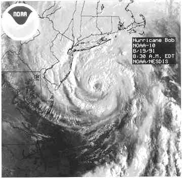
LEFT: Hurricane Bob heading for the Northeast coast in August 1991. At the time of this satellite photo - Bob had sustained winds of 110-mph and a barometric pressure of 28. 14 in. (953 mb.) RIGHT: Buildings swept off their foundations in Buzzards Bay, Massachusetts after Hurricane Bob (photos NOAA/Steven Heaslip-Cape Times).
NORTH ATLANTIC COAST HURRICANE INTENSITY
Since 1900 the most intense hurricanes to strike from Virginia to Massachusetts had barometric pressure readings in the 27.94 to 28.38 inch range (946 - 961 mb). Worldwide - landfalling tropical cyclones with a barometric pressure of less than 28.00 inches (949 mb) are rare. Of the six major hurricanes to strike the c north Atlantic states, only the 1938 hurricane made landfall with a pressure below 28.00 inches.
Wind speed is less reliable than using barometric pressure to determine hurricane intensity. Wind speeds are given in sustained winds (the average of 1-minute of wind). Peak wind gusts may exceed sustained winds by as much as 25%. Wind speeds over 110-mph (category 3 hurricane or higher) have proven to be quite difficult to measure in landfalling hurricanes. In many cases, the equipment fails or is hit by flying objects.
The 1944 hurricane, Hurricanes Edna (1954), Carol (1954), Donna (1960), and Bob (1991), had sustained winds of around 100-105-mph, with peak gusts in the 115 to 135-mph range. Hurricane Gloria (1985) had sustained winds of around 85-mph, with gusts to 115-mph across a narrow area on eastern Long Island.
There have been several peak wind gusts over 110-mph (category 3 hurricane or higher) measured in the North Atlantic states during hurricane landfalls. A peak wind gust of 134-mph was measured at the Cape Henry Lighthouse near Virginia Beach during the 1944 hurricane. During Hurricane Carol (1954), sustained winds of 100-mph with gusts to 135-mph were measured on Block Island, Rhode Island. A gust of 120-mph was measured at Watch Hill, Rhode Island (near the CT/RI state line) during the 1938 hurricane. Hurricane Edna produced a gust of 120-mph on Martha's Vineyard, Massachusetts. During Hurricane Donna (1960) peak wind gusts of 115-mph were measured at Montauk Lighthouse (NY).
The 1938 hurricane was moving forward at a extremely fast rate - up to 56-mph (Pierce 1939, Simpson & Riehl 1981, others). Although some publications have exaggerated the forward speed to 60, 70 even 80 -mph - these estimates have no scientific basis. The combination of sustained winds and rapid forward motion - produced extreme wind gusts to the east of the center. The best estimate of peak wind gusts in the 1938 hurricane are around 150-mph on Long Island and along the Rhode Island coast, and around 130-mph along the southeastern Connecticut coast.
The coastlines of Connecticut and New York are highly urbanized - thousands of structures are located less the 10-feet above sea-level. A repeat of the storm-surge like that of the 1938 hurricane - would have a severe impact on many coastal communities.
LEFT: Densely populated beach communities in Old Lyme, Connecticut.
RIGHT: The beach community of Saltire on Fire Island, New York. This barrier island was swept clean of structures in the 1938 cyclone.
A severe tropical cyclone landfall along the coastline of the north Atlantic states would likely be the most expensive natural disasters in American history. This area is highly urbanized - property values are among the highest in the United States. Losses to insured property in a major hurricane could be staggering in this region. Long Island, New York now has more than $350 billion in insured property alone (IIPLR - 2004). The combined coastal counties of Connecticut and Rhode Island - have insured property valued at $431.9 billion (IIPLR - 2004).
Thousands of homes across the northeast coastal region are located in tidal marshes and along bays and estuaries - some only 6 or 8-feet above sea level. Since the late 1980's - there has been a sharp rise in the construction of vacation homes in coastal Virginia, Maryland, Delaware, New Jersey, and Rhode Island. It has been generations since a severe hurricane has hit the coastal region of this area. Many expensive new homes are located in areas that were submerged in the hurricanes of 1938, 1944, 1954, and 1960. Unfortunately, some of the newest homeowners in this region have no idea they are even in a hurricane zone.
© Michael A. Grammatico 6/05