Hurricane Ivan is one of the three most significant hurricanes to strike the Alabama coast in 106-years. Since 1900 (with the exception of Hurricane Frederic in 1979) - no tropical cyclone has struck Alabama with greater intensity. Many sources now estimate the destruction caused by Ivan is greater than the magnitude of damage caused by both Frederic and the 1926 cyclone. Thousands of homes in the three-county coastal area of Baldwin, Escambia, and Santa Rosa, were damaged or destroyed. Ivan was the first major hurricane (category 3 or greater) to strike the northeast Gulf coast since Opal in 1995.
In September 2004, Hurricane Ivan developed into one of the largest and most intense tropical cyclones ever observed in the Atlantic basin. During a period of 22-days - the storm left a trail of damage and sorrow across the Caribbean nations and the southeastern United States. The effects of Ivan were felt across a 3,000-mile track - from Barbados to Nova Scotia. When the cyclone was located between Cuba and Central America - sustained winds were measured at 165-mph with a barometric pressure of 26.87 inches (910 mb). This made Ivan the 5th most intense hurricane ever observed in the greater Atlantic Basin (1850-2006).
Hurricane Ivan was a classic Cape Verde cyclone that traveled thousands of miles across the tropical Atlantic during the very busy 2004 hurricane season. Like many severe Atlantic hurricanes - Ivan developed from an area of convection that originated off the west African coast. Ivan became a tropical depression about 1,750-miles east of the Lesser Antilles on September 2nd, while drifting westward toward the Caribbean Sea. On September 5th, when the storm reached a position about 1000 miles east of the Windward Islands - the intensifying storm became Hurricane Ivan. As Ivan steadily moved westward in the deep tropical Atlantic, the storm made several fluctuations in intensity between a category 2 and 3 hurricane.
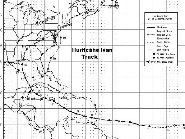
The 3,000 mile path of Hurricane Ivan in September 2004 (courtesy National Hurricane Center 2005).
THE CARIBBEAN
As Ivan approached the Windward Islands late on September 7th, the storm underwent a rapid strengthening phase. Sustained winds quickly jumped to 125-mph as the eye of Ivan passed about 6-miles to the south of Grenada. The southern part of the intense eyewall slammed into the tiny island-nation of Grenada with full force. The intense winds destroyed nearly 90% of the homes on the island, killing 39 people and leaving thousands homeless. In St. George's, Grenada's capital, police fired tear gas to try to stop a looting frenzy. Hundreds of people, including entire families with children, smashed hurricane shutters and shop windows, desperately seeking food and water. At least 14,000 homes were damaged or destroyed. Ivan was the worst hurricane to strike Grenada since Hurricane Janet in 1955.

Southern Grenada after Hurricane Ivan passed just to the south of the island. Not since Hurricane Janet in 1955 had Grenada suffered such a storm (Photo WW-2004).
As Ivan passed south of Grenada early on September 8th, the storm continued intensifying - fluctuating between category four and five strength as it swept through the southern Caribbean Sea. Ivan passed about 20-miles to the south of Jamaica, thankfully sparring the island a direct hit. Although the intense center of the hurricane was 20-miles away from Jamaica, the island suffered significant damage - with 47,000 homes damaged or destroyed, while the famed Negril resort was battered. There were 17 lives lost in Jamaica during the storm. A weather reporting station on Jamaica reported sustained winds of 133-mph (instrument limit). Total damage on Jamaica was estimated at $300 million..
As Ivan passed south of Jamaica early on September 11th, the cyclone once again intensified over the warm Caribbean waters. At 1800 GMT of September 11th, NOAA Hurricane Hunters reported sustained winds in Ivan had reached 165-mph - while barometric pressure had plunged to 26.87 inches (910 mb). This made Ivan the 5th most intense hurricane ever observed in the greater Atlantic Basin (1850-2004).

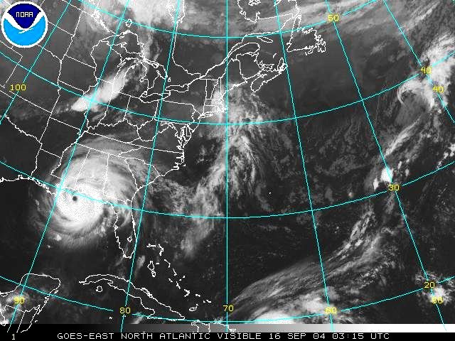
IVAN AT PEAK INTENSITY. At the time this satellite photo was taken - Ivan had sustained winds of 165-mph (gusts 195-mph) and a barometric pressure of 26.87 inches. Fortunately, Ivan weakened by the time it reached the United States mainland (Photo courtesy NOAA).
Although Ivan weakened as it passed just to the south of the the Cayman Islands, Grand Cayman Island was battered. Wind gusts of 150 - 175-mph roared across the narrow island, resulting in widespread wind damage, while the huge storm surge completely submerged the island, except for the extreme northeastern portion. Despite strict building codes, and few of the shantytowns common in the Caribbean - hundreds of buildings on the Cayman Islands had there roofs blown-off. Many hotels were also damaged - including the famous Beach Club Colony Resort, whose second floor was torn off. Debris blanketed the Caymans for months after the cyclone. Two deaths were reported on Grand Cayman. Several estimates place the number of homes damaged or destroyed on Grand Cayman at 70%. At the time of this writing, total damage on Grand Cayman is estimated at $1.6 billion. A weather reporting station on Grand Cayman recorded sustained winds of 150-mph with a gust of 171-mph.
As Hurricane Ivan was passing through the Yucatan channel, the cyclone regained category five status. On September 14th, the eastern end of Ivan's 160-mph winds passed over extreme western Cuba, causing heavy damage. Sustained 120-mph winds with gusts of 162-mph were measured in Pinar del Rio city. Cuban state television reported waves up to 15-feet crashing onto the southern coast of the Isle of Youth, southwest of the main island. Ham radio operators reported downed trees and power lines (NHS). The storm then emerged in the southern Gulf of Mexico on late September 14th as a category 4 hurricane with 145-mph winds.
Ivan then turned more northward and slowly weakened as it approached the United States central Gulf coast. As Ivan closed in one the United States mainland - more than 200,000 people evacuated the middle Gulf coast. Although unfavorable meteorological conditions and cooler waters caused the hurricane to slowly weaken as it crossed the Gulf coast - Ivan still entered the U.S. mainland as a major hurricane.
Hurricane Ivan makes landfall near Gulf Shores, Alabama with winds of 120-mph and a 10 to 15-foot storm-surge (Photo NOAA).
THE UNITED STATES - METEOROLOGICAL CONDITIONS
At 2:02 CDT , the eye of Hurricane Ivan eye crossed the coast just to the west of Gulf Shores, Alabama, as a strong category 3 hurricane, with sustained winds of 120-mph, and gusts of perhaps 160-mph. Ivan hit the Alabama and extreme northwest Florida Panhandle communities with horrendous force. By the time cyclone had reached the Alabama coast, the eye diameter had increased to 45 miles wide. This resulted in some of the strongest winds occurring over southern Alabama and the western Florida panhandle. The strongest ground level winds were recorded on the oil drilling platform Ram Powell-VJ956, located about 70 miles south of Mobile Bay, Alabama - sustained winds of 117-mph with gusts to 155-mph were recorded until the wind measuring equipment was destroyed.
An unofficial wind gust of 145-mph was recorded by a sailboat anchored in Wolf Bay, north of Orange Beach, Alabama. Storm chasers near Gulf Shores, Alabama recorded sustained winds of 89-mph with gusts to 114-mph. The highest official wind measurement recorded in northwest Florida was 87-mph sustained with a gust to 107-mph at the Pensacola Naval Air Station, at 3:06 am CDT on September.
Aircraft Reconnaissance measured a barometric pressure of 27.94 inches (946 mb) as the center of Ivan crossed the Alabama coastal islands. The National Weather Service Office located on Bates Field in western Mobile, recorded a minimum central pressure of 28.48 in. (964 mb). Brookley Field, located 32-miles northwest of the eye, measured a pressure of 28.23 in. (956 mb). Both of these stations were not in the eye of the Hurricane Ivan. Unofficial reports from storm chasers close to the eye were as low as 27. 86 in. (943 mb).
Hurricane Ivan produced a storm-surge of 10 to 15-feet from Destin in the Florida panhandle westward to Mobile Bay/Baldwin County, Alabama. According the NWS-Mobile, Ivan storm-surge exceeded any previous hurricane from Fort Morgan, Alabama east to near Navarre Beach, Florida. The surge along this stretch of coastline was 10 to 12-feet high. Fortunately, the center of Ivan passed to the east of downtown Mobile, preventing a devastating storm surge. Incredibly, a wave height of 52.5 ft was reported by a NOAA Buoy located in the north central Gulf of Mexico as Ivan approached Alabama.
Ivan crossed the barrier Island communities of Alabama, then turned northeastward across Alabama, weakening to a tropical storm. The weakening storm continued moving through the southeastern United States, weakening to a topical depression over northern Georgia and Tennessee. The dying cyclone produced heavy rains from North Carolina to Nova Scotia. Ivan dumped as much as 3 to 7 inches of rain across the Atlantic states from Virginia to Massachusetts. Ivan even managed to make a counter-clockwise loop south of Long Island, New York, and move back southward as a minimal tropical depression.


RIGHT: Ivan's 10 to 15-foot storm surge leveled beach front communities in Gulf Shores, Alabama.
LEFT: Roof ripped-off buildings in Gulf Shores, Alabama after Ivan. Peak gust may have reached 135-140-mph. (Photos Courtesy NWS Mobile).
THE IMPACT
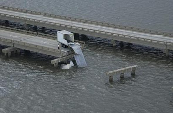
Ivan caused severe damage in Baldwin County, Alabama, and Escambia and Santa Rosa counties, in Florida. The worst damage was the result of the 10 to15-foot storm surge that swamped coastal communities. Ivan's huge storm surge swept away a section of Interstate 10 (I-10) across Pensacola Bay. A quater-mile of the bridge collapsed, leaving this main highway impassable. U.S. Highway 90 was also damaged.
Some of the worst damage from Ivan was in the Perdido Key, Florida area. The fury of wind gusts over 140-mph - along with a 15-foot storm surge - leveled the subtropical resort island. The barrier islands suffered a huge amount of overwash across the coastal highway. Days after the cyclone, drifts of sand 30-feet high covered homes and automobiles across the islands.
The worst damage in Alabama was along the Gulf Shores and Orange Beach areas, and across the coastal waters. As Ivan was closing in on the Alabama islands - towering seas and 140-mph gusts swept away several oil drilling platforms. Along the Alabama coast, many structures collapsed long before the peak winds reached the coast - as the wave action had scoured the sand beneath the foundations causing them to crumble into the raging surf.

A coastal home is buried in five feet of sand in Perdedo Key, Florida ( Photo USGS).
As Ivan moved over interior Alabama, Florida, and Georgia, the high winds downed tress and power lines. Six hours after the storm had passed through the middle Gulf coast - more than 1.8 million people were without power. Hurricane Ivan's passage resulted in 39 deaths across the Caribbean and the United States. At the time of this writing the total damage from Ivan has been estimated at $14.2 billion.
© Michael A. Grammatico - January 1, 2006