Case Study
ARNHEM LAND PLATEAU, NORTHERN TERRITORY, AUSTRALIA
Introduction
@The Australian case highlights several themes relevant
to working landscapes globally. First, it discusses indigenous co-management of resources
in both Kakadu National Park and Arnhem aboriginal lands, in cooperation with the
government of Australia. Indigenous and aboriginal peoples of the world are often
overlooked or brushed aside in conservation science. Until recently, they have only
rarely been explicitly considered to be a part of the ecosystems or the biodiversity
the international science community seeks to conserve. Their potential role as partners
in the goal of sustaining biodiversity for the future has often also received scarce
attention. This is regrettable given that many of the world's hot spots of biodiversity
also correspond to lands where indigenous peoples retain de facto land tenure and
still engage in traditional resource management activities. It is all the more tragic
given that the threats to biodiversity in many regions often have their roots in
a history of exploitation, conquest, and dispossession of native people and their
lands, as is the case in Arnhem land.
@In addition, however, the Australian case profiles
the recent and rapid development of a vibrant, collaborative restoration movement.
The Landcare movement has taken root in the non-aboriginal or semi-acculturated lands
of southwest Arnhem Plateau, where a century of imported European agricultural practices
and other activities have led to severe land degradation. It is, however, linked
to a growing network of grassroots and state-sponsored local organizations throughout
Australia involving thousands of individual participants. Based on mutual concern
for the health of the overall ecosystem, Landcare groups also actively communicate
and collaborate with the aboriginal people of Arnhem Land and Kakadu National Park.
Physical Description
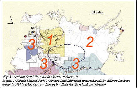
@Arnhem Land Plateau is an ecological region covering
about 180,000 km2. It is surrounded by seas on three sides and the Western Australian
Shield (dry bushland and desert) on the fourth. It comprises a drainage system which
begins in a relatively mountainous ridge area (with elevations up to 2500 m) and
includes three main watersheds: decentralized streams in the northeast, Roper River
Watershed in the south, and Daly-Alligator River Watershed Clusters in the west and
northwest.
The climate is delineated by the wet season (Nov-Mar) and the dry season (Apr-Oct).
Most of the 130-150 centimeters of annual rainfall is concentrated during the wet
season. This level of rainfall tends to leach the already acidic soil (mainly sand
and silty loam), making this area of Australia one of the poorest in soil fertility.
In addition, seasonal extremes in stream flow can lead to high levels of erosion
in non-vegetated areas.
@The plateau consists of 8 major habitat types: 1) sandstone
escarpments; 2) monsoon forests; 3) riparian zones; 4) floodplains; 5) paperback
swamps; 6) eucalyptus woodlands; 7) mangrove forests; and 8) coastal areas. Some
ecosystems are of great significance in terms of their biological diversity. For
example, the Plateaus tidal flats contain almost all of Australia's mangrove species.
The plateau is home to hundreds of species including 62 mammals, 280 birds, 123 reptiles,
25 amphibians, 51 freshwater fish, thousands of invertebrates, and 1,600 plants.
Native species are threatened by numerous exotics that have become naturalized in
the wake of European settlement, including feral buffalo, the floating fern, and
the prickly shrub. The keystone species are buffalo, termites, and ants. Feral buffalo
play vital roles in microhabitat modification, while termites and ants mediate nutrient
cycling and seed dispersal.
@The primary natural disturbance regime is fire. 50%
or more of the savanna vegetation burns annually during the dry season. The primary
fuel is understory vegetation, which is dominated by native grasses. In wooded areas,
fires are not carried in the canopy because the dominant tree, eucalyptus, does not
hold much flammable oil in its leaves.
The Approaches
Top-Down Collaborative Conservation (Kakadu National Park)
@Kakadu National Park lies 257 km from the city
of Darwin along the access-restricted Arnhem Highway. It is 20,000 km2 and includes
the entire catchments of both the South Alligator and East Alligator Rivers.Twenty-five
years ago, pastoralism, uranium mining, and traditional aboriginal use dominated
the area. In 1979, however, the federal government proclaimed a small part of the
area a national park and placed it under the ownership of the local Aborigines. Several
years of expansion followed in which two significant actions were taken: 1) old pastoral
leases were terminated, and 2) in-park mining companies agreed to site restoration
and mitigation in exchange for continued operations. The park is now listed as a
world heritage site under the UNESCO Convention Concerning Cultural and Natural World
Heritage and the Ramsar Convention on Wetlands of International Importance.
@This aboriginal-owned national park is regarded as
a model for co-management by tribes and conservationists. The indigenous Northern
Land Council and three local tribal associations collectively established the Land
Trust and leased land-use rights for Kakadu land to the National Park Administration.
Through this new partnership, the traditional landowners jointly manage their own
lands with conservation scientists and outside experts.
@This subunit serves all local residents as well as
outside communities. Some Aboriginal tribes continue to inhabit the park (as is their
right as landowners) and sustain a traditional lifestyle. They have primary use of
the land but, for the most part, avoid areas of the park where they are likely to
meet visitors. In the 1990s, the visitation rate was up to 200,000 people annually.
The related tourism and service industry around Kakadu National Park became the biggest
revenue earner in the whole Northern Territory, second only to mining. It is estimated
that tourism brought US$20.5 million each year to the Territory and was responsible
for 6% of employment. In light of the varied uses and interests in the park, the
joint Board of Management reviews the shifting cultural as well as environmental
considerations on a daily basis.
Conservation
Exotic Weeds. During a brief period of pasture development in Kakadu, exotic
pastoral species were introduced. Those introduced plants, which included 29 grass
species, became weeds. Proliferation of these exotic weeds has caused park managers
to consider a conservation program to address alien plant invasion. Their measures
include restoring native species and monitoring hydrological cycles, fire regimes,
and visual impacts.
Fire Management. Aboriginal people and pastoralists all understand how to
use fire as a widespread management tool in this region. Kakadu National Park managers
utilize the Aboriginal traditional burning techniques, which were developed over
millennia. This expert system prefers "cool" burns in the early dry season
to reduce fuel loads of savanna grasses and woodlands. Prescribed fires burn along
roadsides, and around buildings and fire sensitive habitats. Aboriginal inhabitants
of the park also undertake burning in their areas as a traditional resource management
and hunting practice. It is estimated that 35% of the lowland, 31% of the escarpment
and 25% of the floodplain are burned annually. These cool fires cause little permanent
damage to savanna woodlands because of thick protective barks and fire-adapted life
cycles. The patchy mosaic (unburned, early burned, and late burned lands) recreates
the similar pattern of traditional Aboriginal burning, and is proven to maintain
native flora and fauna.
Kakadu National Park

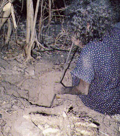
Grassroots Traditions (Aboriginal Land Reserve)
@Aboriginal Land Reserve, over 94,000 km2, is totally
private indigenous land. The area has been the home of many different Aboriginal
clan groups for 60,000 years and even today as many as 40 separate languages are
spoken. Tribes of the Yolngu group currently inhabit the Reserve. These Aborigines
maintain a hunting-and-gathering lifestyle, but have incorporated cash income through
trading and federal welfare benefits.
@In the colonization period from the nineteenth to twentieth
centuries, the Aboriginal diaspora pushed them into the interior of Arnhem Land.
White pioneers established pastoral stations (fenced-in camps) and integrated the
Aboriginal people into range life as labor and low-level managers. In 1931, however,
after a number of indigenous rights movements and riots, the federal government reserved
the whole northeastern part of the Plateau for the use of the Aboriginal people.
The Land Right Act of 1976 gave these tribesmen power to establish the land-claims,
thus allowing aboriginal owners to sustain their traditional hunting-gathering fields
as private land.
@In many ways the Aboriginal Land Reserve is a truly
integrated ecological and cultural working landscape. On the one hand, the Yolngu's
hunting-and-gathering lifestyle requires a diverse landscape to sustain it. This
is partially achieved through traditional ecological management tools, such as prescribed
burns, which allow the people to modify the landscape sustainably as they travel
through the lowlands and mountains of the Reserve. On the other hand, they believe
the continuation of all life depends on the correct performance of the stewardship
acts invented by their ancestors. In their worldview, cultural identity is a complex
relationship between kinship, ancestry, and environment that requires they perpetuate
ecological management. As a consequence, maintenance of environmental productivity
and biodiversity are their personal responsibilities, and any declines are viewed
as a result of their own failures.
@Tribal people traditionally maintain low human impact
on the local wildlife and landscape patterns. However, their grassroots landscape
approaches have gradually become influenced by modernization. Prior to external contact,
the aboriginal people were self-sufficient, but recently they have become partially
dependent on market foods. It appears that the introduction of market commodities
and technology, and the payment of welfare benefits in cash, has resulted in some
transformation in subsistence production. However, further information on their lifestyles,
social institutions, and land management is limited for outsiders.
Arnhem Land
|
|
|
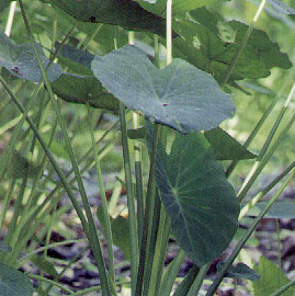
Taro Lily (Cunjevoi) and green ant nest |
Collaborative Community-based Conservation (Landcare Movement)
@The region outside the protected areas has been
settled by Euro-Australians since the nineteenth century. This population is concentrated
in the cities and hinterlands of Darwin, Daly River, Katherine, and Roper Valley.
Each area has a different use and history: Darwin, the largest, is a remodeled park-like
multi-cultural city with over 50 ethnic groups and nationalities; Daly River is a
sparsely populated landscape devoted to pastoral use; Katherine has a history of
heavy gold mining; and Roper Valley is dominated by farming and grazing.
@In all these areas, introduced agricultural, pastoral,
and industrial practices have been found to be highly inappropriate for the landscape,
which in turn affects the people. Lands are stressed with deepening crises in depletion
and degradation of water, soils, and endemic flora and fauna. Soil erosion and productivity
loss is high. Many farm families have abandoned their land, and those who remain
are running larger farms with fewer people and higher levels of debt and stress.
Access to facilities such as schools and hospitals is declining, and rural towns
are withering socially and economically. This part of Australia demonstrates how
a landscape can be degraded to the point of being severely limited in the work it
can do for itself and the people who depend on it.
@To help alleviate these problems, in the early 1990s,
farmers and rural residents in the Plateau began to form voluntary groups to tackle
problems such as salinity, wind erosion, and pest issues at a district scale. They
registered under the title of "Landcare" as part of a nation-wide community
conservation movement. In the mid-1990s, Landcare gradually switched from a federally-funded
national project to a partnership-based co-management and collaboration between communities
and government. Currently, the number of Landcare groups in urban, rural, and coastal
areas is swelling and there is substantial evidence that Landcare is becoming gaining
importance in the international community.
@Landcare groups are proven to solve problems at a district
scale which cannot be effectively tackled at the individual property level, especially
water-related issues (salinity, erosion, waterlogging, water quality decline, and
irrigation management); nature conservation (preservation of biodiversity); and management
of vertebrate pests and weeds. In general, a Landcare group is composed of up to
100 volunteers who work together to develop more sustainable land management for
500 to 15 million ha. Landcare groups create collective social pressure in favor
of developing more sustainable farming systems, reinforcing and supporting individual
farmers who are ready to abandon their lands, and encouraging others to become involved
. Landcare projects cover almost all of Arnhem Land Plateau outside the protected
areas, and membership among primary producers is close to 50%, the highest of any
State or Territory in Australia.
@Most Landcare activities focus on pastoral areas and
attempt to avoid erosion and salinity and to reduce destructive management practices
such as clearing, fertilization, and tillage. Bushcare and watercare also emphasize
increasing wildlife habitat and promoting biodiversity. In addition, a number of
Landcare groups (including rural aboriginal tribes) work on vegetation restoration
and community-based watershed management.
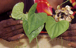
 Long Yam