
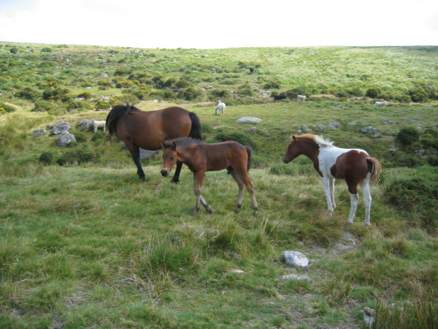
| The walk starts at the car park in the little village of Postbridge, SX646788. At the car park is a National Park information centre and shop, where you can get friendly advice and find a good selection of maps, books, souvenirs and all kinds of other things. Leave the car park and turn left on to the main road through the village, passing the post office shop and crossing the East Dart River by the road bridge. Off to the right you can see the old clapper bridge. A short distance after the bridge is a gate on the left, with a footpath sign. The path takes you along two sides of a field, passing westwards in front of a pleasant looking large house, called "Hartyland" according to the map (SX644795 - actually, if you zoom out on the Ordnance Survey map, you can see much of the walk route at once). Now I find that Hartyland is connected to an organisation called "2WayTrust". There is a good picture of the place on that website. Anyway, after passing the front of the house, you find yourself on the bank of the river, and the path turns a little west of northwards through a gate in a wall. Care is needed here! A path near the river is visible directly ahead, but it soon gets very narrow and scratchy from tough old gorse bushes. If you want to avoid that, go a little uphill and take another path which soon appears. This one leads pleasantly along the top of a hill, which slopes down westwards to the East Dart. Eventually the river bends off to the west, and the path descends to a stream which can easily be crossed by stepping stones. There generally seems to be a group of cows and bullocks enjoying the facilities of the stream too, but they always shift aside willingly enough. There is a picture of some of them on the right. | |
In 2006 the group of animals was accompanied by a bull, but whatever breed of cattle they are, the bulls are pretty docile. This one just glanced at us when we disturbed the cows standing on the path. Actually this makes a third bull: we only ever saw one a few years ago, but he was later joined by a second. This pair seem to be great friends, always bellowing and head-butting each other in a macho sort of way. I've tried looking up breeds of cattle on the internet, to find out what they might be, but I just couldn't find any very simple identification site!
 |
There are far more sheep around than cattle, but they generally stay as far away from humans as they can, or at least the white-faced (Lleyn breed) and black-faced (Blackface breed) do. There is another breed, the white face Dartmoor, with rather broader faces, and these are much more bold. In fact some of them once refused to shift from the path they were lying on, and we had to step over them. But there aren't so many of this sort wandering on the moor. Actually it seems they are an endangered breed - see here for more information. |
In Wales we have often come across sheep that come towards us instead of running away. They seem to be those that were hand-reared as lambs, and have better expectations of human beings as a result. None of these on Dartmoor so far, though.
 |
There are likely to be groups of the delightful Dartmoor ponies around too. Some of them are very friendly, but you should not feed them, as it encourages them to seek out human beings at the roadside, with inevitable accidents. Their gentleness and friendliness makes them ideal for children learning to ride. The late Lancelot Hogben (to whom I am eternally grateful for "Mathematics for the Million", "Science for the Citizen", and, together with Frederick Bodmer, for "The Loom of Language" - in fact, for inspiring most of my interests!) wrote, "On Dartmoor, my eldest child Sylvia took to horse-riding. At the annual roundup, a Dartmoor pony could be purchased for a pittance at Widecombe Fair a few miles from our cottage. During the thirties such wild ponies often mated with others of high pedigree let out by their owners to graze on the moor." |  |
("Lancelot Hogben: Scientific Humanist", edited by Adrian and Anne Hogben, Merlin Press, 1998, pp 124-5). They still only sell for a pittance now, and the administration fees needed for selling them are often more than their worth. Farmers are not so willing to keep them as a result, and the numbers of the breed are declining. There is a lot of information about Dartmoor ponies at the website of the Dartmoor Pony Heritage Trust.
When approaching ponies, be sure they are aware of your presence - say "hello" or something. If a pony gets an unexpected touch from behind, it is likely to kick out first and look round afterwards. Apparently even cows can get aggressive if surprised, though we have never had any trouble with them.
Anyway, the stream is easy to cross by stepping stones. Beyond it, the path climbs and continues more or less northward. There are a couple more streams to cross, but they don't present any difficulties. The trend is generally uphill, and to the right you will see the dark green of Fernworthy Forest, a plantation surrounding Fernworthy Reservoir. The path gradually draws nearer to the trees.
| Eventually the Grey Wethers appear straight ahead, as shown on the right. They are two circles of grey stones, the circles almost touching each other. The centres of the circles are aligned North South, and the stones were originally set up in Neolithic times, sometime between 4000 and 2500BCE. By the early 20th century many had fallen, but the circles were reconstructed in 1909. There was a lot of controversy over whether or not such reconstructions should be carried out, but the result is very beautiful and undoubtedly reflects the original intention, at least as to appearance. But no doubt we will never know why the circles were originally set up, or the reasons for the many other neolithic and Bronze Age antiquities that can be found all over the moor. There is a lot more information to be found in this Wikipedia article on Dartmoor. There's another Wikipedia article on the Grey Wethers themselves, with a pleasant story about the origin of the name, though "wether" actually refers to a castrated ram, rather than a sheep in general. | 
|
You may feel that reaching the Grey Wethers was effort enough, and indeed they make a fine conclusion to a walk before heading back to Postbridge. On the other hand, there are a couple more interesting things to see not too far away. Just beyond the Wethers there is a wall, which climbs up Sittaford Tor just to the West. There is a path up the tor just beside the wall, and the view from the top is pretty good. Leading south west from the top of the tor is a very obvious path down to a stream and then up again on the far side of the little valley. Follow this path - it may be rather wet near the stream, but it's generally manageable. Near the top of the hill on the far side, you will find the remains of a 19th century peat cutters' cottage, known as Statts House (SX621824). Peat cutters must have been pretty hardy folk - the nearest pub, the Warren House referred to in the Wikipedia Grey Wethers article, must be a good two hours walk away!
 |
On the left is a photograph of Statts House, and on the right one of my wife and me inspecting the interior, which must have been spartan even before it became a ruin! | 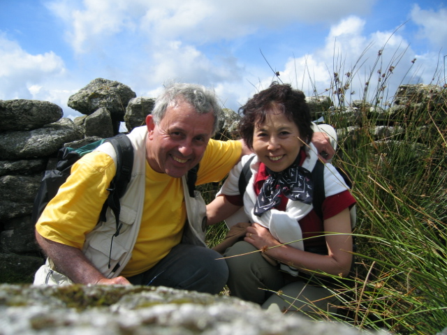 |
| If you hunt around a bit to the north and west of Statts House, you will come across the start of a peat pass. To the right is a photograph of me leaning on the granite marker at one end of it. As you read in the linked article, the peat passes were organised by the keen huntsman Frank Phillpotts, who wanted to arrange safe passages for horses during hunts. Before I actually saw this one, I imagined great cuttings through the peat, towering over my head. In fact they are only a few centimetres deep, and just about invisible in the photo! Still, as long as horses and cattle found them safer, I have no complaint. |  |
Certainly time to return to Postbridge now. There's more about Statts House, and alternative walks round about it here.
Google Earth also gives a detailed view of Dartmoor now, and you can find the start of the walk at "Postbridge UK". It's not so easy to pick out the features from the aerial view, however. The Grey Wethers can be found by the keen eye at about 50° 37' 55.08" N, 3° 55' 35.50" W.