The GPS / Barograph Record of a Wave Flight
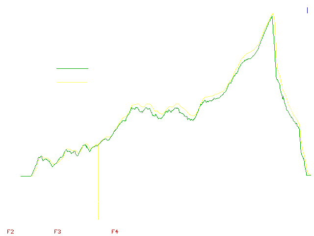
Take-off at Fremont County Airport (1V6) towards West (Runway 29), with 2200 ft (700 m) airtow. During tow went through strong rotor lift immediately after take-off, could have probably released at 1500 ft (450 m). Went beyond lift, turned back, released in weak lift, lost 800 ft after some scratching, finally at low point of 6522 ft (1988m) figured out how this day the rotor-thermals worked (rotor-thermal = my expression, but let's separate wave / rotor fiction - rotors more or less stationary - from wave / rotor reality - rotor-thermals often moving with the wind, forming and falling apart ). Climbed to around 14,000 ft ( about 4,300 m) in several rotor-thermals over the hills North of the airport, tried to explore the wave system over the valley North of Canon City running towards Victor and Cripple Creek. Moved forward to the lee of Curley Peak, entered the wave (mostly still rotor-thermals at 12346 ft - 3783 m). Around 15,100 ft (~ 4600 m) cruised forward into the wave. Rotor-thermals were under the clouds, the wave itself was about 1 km in front of (to the West of) the leading edge of the rotor clouds.
Called Denver Center on 128.375 at 16,500 ft ( ~ 5000 m). Requested Curley Peak Wave Area #2. This was not available due to the Fremont MOA (Military Operations Area) being "hot". Asked Center if Area #3 was free, which it was. Center asked to call when I am entering, which I did about 5 minutes later. They were interested to know how long I would be in the area, I told half an hour or less. Reported to Center each Flight Level (190, 200, etc.). Requested clearance first to FL 230, then at FL 220 to FL 250, which were granted. Reached FL 250 with no problem in 700 - 800 fpm (3.5 - 4 m/sec) lift. Informed Center on reaching FL250, commencing high-speed descent, then exit from the wave area at 18,000 ft (5486 m). While still climbing, Center was interested in my plans after exit from wave, due to high-speed low altitude military traffic at 8000 ft (2438 m) and below, I indicated cruise to Fremont County Airport between 16,000 and 18,000 ft (4877 m - 5487 m). Landed at Fremont County Airport in 20K SW wind.
The GPS / barogram record above was made in a Colibri FAI logger, using the LXFAI program output.
![]()
![]()