Memorial Day Weekend, 2004
It was a superlative weekend � as in, a weekend filled with superlatives like �largest�, �tallest�, �most beautiful� and so on.
We�ve been playing auto tourist most weekends in
Friday evening, we left
We stopped at the Holiday Inn Express in Three Rivers, got
up early the next morning and headed into
There are two main kinds of redwoods in
The National Park road travels up from about 1,500 feet of
elevation to about 4,000 feet and begins to enter some of the redwood
groves.�
Saturday of Memorial Day weekend and an early start in the morning gave us an almost empty park to drive through.� The scenery was beautiful as the road twisted and turned its way up to the higher elevations.� Once you are high enough, the amazing Mountain Redwoods appear.
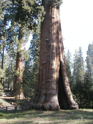
�Massive� is the only term that describes these trees.� �Standard� trees narrow as they get
taller.�� The mountain redwoods do
narrow, but not very much:� they look
more like a column.� When that massive
column is 250+ feed tall and 60 feet around, that is a
We found our way over to the General Sherman tree (named
after the Civil War general).� It is
acknowledged as being the largest (as in �massive�) tree in the world.� This tree (which is still growing) weighs
more than two 747s jet airliners or 11
Pictures simply cannot do it justice, but we tried.


The climate in the area where the General Sherman is located is apparently the best in the world for the Sequoias � several of the largest sequoias are within a 5 square mile area.� They require moisture year round (not necessarily rain, but the ground needs to remain moist), not too cold (so they don�t grow above 5,000 feet) and specific other criteria to thrive.
Oddly enough, one of the criteria is fire:� fire is a critical element of the Sequoia reproduction cycle.� Mature Sequoias don�t have too much trouble with fire:� their bark is extremely thick, the branches are usually high enough not to catch file and Sequoias heal quickly.
The heat of the fire causes certain cones on the Sequoias to open and scatter seeds.� The fire also clears off the underbrush and provides a fertile environment for the seeds.
The National Park Service has now started letting the lighting strike started fires continue and burn out:� when the fires were stopped, no new sequoias were being germinated.
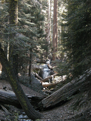
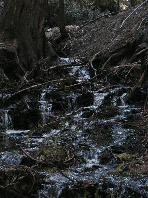
There is a nice trail around the General Sherman area and it is truly beautiful.

We continued across the upper spine of the mountains to
King�s
On Saturday, we headed north into
San Franciscoians have to build on the steep hills; there simply isn�t anywhere else in the area to build.
We crossed the


Suddenly, the climate and terrain were startlingly different.
Southern California is, on the whole, desert (if you want to
see what mountains here in Southern California look like, watch a rerun of MASH
� it was filmed about 15 miles from our apartment in the Santa Monica
mountains, and it is pretty representative).�
It is amazing how
The Avenue of the Giants is in
These trees are also, on the whole, younger than the Sequoias.� They look more like �regular� trees (i.e. they narrow as they go up); they just go a LONG way up.


We spent a pleasant afternoon driving, stopping and sightseeing.� We took a side road that took us to the �Giant Tree�, which, at 363 feet, is currently accepted as the tallest tree in the world.


One of the more amazing things about this area is the 1964 flood.� There is a river that runs through the area (both the Avenue of the Giants and 101 cris-cross it).� In 1964, they had unusually high snowfall, which had the river running high; then 16 inches of rain fell in a 24 hour period across the entire watershed.
This happened almost 40 years ago and you can still see some of the evidence.� One of the towns (primarily caters to the tourist trade) was under 33 feet of water at high water of the flood
CA-101, which is well up on the hill, has signs that show the high water marks.� On most of the drive (with the road looking down over the river), our car would have been completely submerged.� This flood really was amazing � yet most of the Redwoods simply rode it out.


Of course, the man made tourist attractions are there as well, like the Chandelier Tree:


We then turned south and began the trip back to
The


Every so often, the
Monday was Memorial Day and we were concerned about
traffic.� The usual route would have been
to go a bit east, pick up I-5 South and go down the
We cruised down 101 until PCH broke off and then followed PCH south.�
Wow.� I thought the
Northern California PCH was rugged and beautiful:� this section of the highway was more of
both.� Quite twisty and turny, but very
impressive.� We drove through


Once we left

http://www.rocky-point.com/� is their web site and the slide show is worth viewing.� The restaurant sits on the side of a cliff with a rocky point that juts out into the Pacific.� Not quite a bay or inlet, but there are points to both the north and south that shelter this area.
As we were seated, there was a fishing boat working its way North to South, maybe half a mile out from the shoreline.� From what some of the locals were saying, it was working for squid.
Shortly after that, some sea lions swam by, then a large flight of brown pelicans.
Lunch was exceptional, and about half way through, Teresa pointed out to the ocean and asked what that white cap out in the middle was� turned out to be a grey whale, surfacing and browsing through the area (Teresa spotted it before anybody else in the restaurant, but everybody was soon whale watching).� Impressive (although we couldn�t see much beyond the back of the whale as he was just coming up and spouting, then going back to eating).� So, now we have seen a whale.
We worked our way south on the twisty road until we arrived
at
We continued south and left all traces of civilization (including power lines) behind, with the notable exception of PCH.� This area is to the west of San Padres National Forest and it is noticeably UN-developed.� Roads break off to the east (towards 101 from PCH) about every 20 miles or so, but calling them a �road� may be overstating things just a bit� they were asphalt where they turned off from PCH, but I would be surprised if they stayed that way.� There was the winding road, the cliffs, beautiful views of the ocean (with occasional vista points) and occasional cars.� Top speed was about 35 MPH, due to the nature of the road and the slowing to appreciate the views.�

This stretch of the highway went on for about 45 miles, until we arrived at Lucia (preceded by about 5 miles of power lines).� This is a town that is obviously supported by tourism, but it isn�t a �tacky tourist� area by any stretch.� There are lots of restaurants and hotels, but spectacular ocean views are always a short walk away.
South of Lucia, the road was a lot easier to travel (back up
to a cruising speed of about 50 mph or so).�
Then we passed by the entrance to
Elephant Seals need to pull out of the water every so often and dry off and this is one of the places that they do it.� We spent about 45 minutes watching the seals.� None of the big males were there (they migrate and will show up later); they can be up to double the size of the juvenile males that show up in our pictures.� Elephant seals are the �largest� of the seals in the world.
Noisy� these elephant seals are not sea lions that �bark�.� These elephant seals *roared* and when the males were practicing mating fights, it got loud.�


It was a really neat experience and one that I�m very glad we had.
After we left
It was truly a superlative weekend.