1. Introduction
This work examines the fundamen -tal dynamics of Hurricane and it's boundary layer and addition to that also there's short review about the feature of Hurricane as a basis for the subject.
2. Dynamics of matured hurricane
Now, we see the basis Equation about Thermal wind. it is just basic for knowing the hurricane base.
r: radius from the axis of vortex
v: osculated line speed
curving momentum is preserved, so we can say,
remove  ,
,
A thermal longitude function concerned absolute momentum horizontal shear.
and the thermal exchange is like this,
Such a strong temperature exchan -ge is one of the most important thing to the Hurricane.
3.Small scale of feature of hurricanes
To make long story short, hurricanes are tropical cyclones with winds that exceed 64 knots (74 m/hr) and circulate counter-clockwise about their centers in the Northern Hemisphere.
1) Briefing the process of hurricane
Hurricanes are formed from simple complexes of thunderstorms which grow to hurricane strength with cooperation from both the ocean and the atmosphere. The degrees of ocean water has to be warmer than 26.5℃. Related to having warm ocean water, high relative which reduces the amount of evaporation in clouds and maximizes the latent heat released.
The concentration
of latent heat is critical to driving the system. There's another important thing in a tropical cyclone's environment
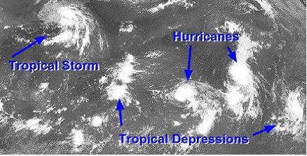
(Fig 1-1). It is a vertical wind shear. Wind shear is defined as the amount of change in the direction of wind or speed with increasing altitude. When the wind shear is weak, the storms that are part of the cyclone grow vertically, and the latent heat from condensation is released into the air directly above the storm, aiding in development.
So, stronger wind shear can make the storms become more slanted and the latent heat release is dispersed over much larger area. As you know, at the equator, ocean is warm enough but there's no hurricane. Because, there's not enough coriolis force to create spin. And the process is following, as surface pressures continue to drop, a tropical storm becomes a hurricane when sustained wind speeds reach 74 m/hr. A pronounced rotation develops around the central core.
Fig 1-1 tropical storm and hurricane
2) Eye, and eye wall
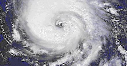
When we see the (Fig 1-2), satellite picture of the hurricane, in the middle of that (between 20-50km in diameter) we can find a dark spot in which rest of the storm rotates and where the lowest surface pressures are found so relatively clear sky is seen. And this is called the eye. the eye is the region of most intense winds and rainfall called the eye wall. Cause the eye is Surrounded by deep cumulonimbus which looks just like wall. Large bands of clouds and precipitation spiral from the eye wall and are thusly called spiral rain bands.
The clear sky of the eye is for the strong surface winds that converge towards the center never reach it. The coriolis force deflects the wind slightly away from the center, causing the wind to rotate around the eye wall, leaving the exact the eye calm. The surface pressure continues to drop through the eye wall and into the center of the eye, where the lowest pressure exist. Upon exiting the eye, both the wind speed and pressure increase rapidly. The wind speed reaches a maximum in the opposite eye wall, and then quickly begins to decrease. The wind and pressure profiles inside a hurricane are roughly symmetrical, so a quick rise in winds and pressure through the eye wall followed by a slower increase in pressure and likewise decrease in wind speed would be expected
Fig1-2 The eye
4. Research about the hurricane boundary layer as an interest in outer rainbands.
1) Spiral rain bands
Much rain is found spiral bands. We can see a banded structure within the clouds, which are called spiral rain bands There are a little regularily places with no rain. If we go through to the hurricane, we'll meet a light rain almost dry and then more intense rain again. It can be explained by following (Fig 1-3). The thunderstorms have regions of rising and sinking air. Most of the air is rising, but there is a small amount sinking.

Fig1-3 regions of rising and sinking air
2) Research about the Hurricane boundary layer by Powell, Mark D.
The Hurricane planatery boundary layer(HPBL) is major important and maintenance of the storm. The frictional coupling of the Hurricane vortex to its underlying surface produces both shear and buoyancy induced turbulence that supplies moisture and heat to the storm and provides a sink of momentum, resulting in inflow and upward motion due to convergence the hurricane planatery boundary layer is defined by nearly continuous turbulence that is initially produced by shear at the underlying surface. It is bounded above by the area where convective turbulence becomes important cloud base or a region where surface induced turbulence no longer exists, such as an inversion.
a. Summary of the research
The mesoscale rainfall and kinematic structure of hurricane Josephine and Earl show many characteristic that appear to be typical of well organized, convective outer rainbands.
① The rainbands were 15~20km wide. they comprized a linear aggregate of precipitation element containing individual cellular reflectivity maximum that were constantly developing and decaying over time scales of 15~30min. The cells were located preferencially toward the upshear side of the band axis and moved along the band.
② The wind field related with band exhibits a strong cyclonic horizontal shear across the band, with along and crossband wind maximum on the inner side. Maximum convergence is near the updraft axis, with maximum vorticity between the updraft and rainband axes.
③ An increase in cyclonic shear across the band, with minimum along speed on the inner side and maximum along speed on the outer side of the band.
b. Comparison with tropical squall lines
Both within and avobe the boundary layer, the hurricane rainbands is compared with tropical rainbands and squall lines.
The similarities are like followings.
① Orientation of the convection is perpendicular to the low level crossband or
crossline vertical shear vector of the horizontal wind
②Maximum low level convergence and barrier effects are at the mesoscale updraft position with pressure minimum produced by hydrostatic and dynamaic effects.
③Warm, moist, low level inflows can be supplied from the relatively undisturbed environment ahead of the direction's motion of system.
And, the differences are like followings.
①The hurricane rainband updraft is on the upshear side of the band. The more intense cells are on the inner side of the band axis and contain cool convective scale downdraft. These cells help to force the updraft and tend to spread in a shallow flow downwind on the inner side of the band. The cool dry air and down shear extention of rain toward the outside give the appearance of a squall line leading edge to inner trailingg edge of the hurricane rainband.
② The air spreads out at the surface as a gust front, moving westward at high speed of 10~20m/s. The motion causes a squall relative flow from front to back at all levels with maximum storm relative inflow near the surface. The line propagates by discrete growth of the new cell of which form at the front and move rearward relative to the system.
③The hurricane rainband may be storm stationary, outward moving or intrinsically inward moving while seen to move outward(Fig 1-4).The outer convection rainband has a profound effect on the kinematic structure of the HPBL. The thermo- dynamic structure of it is also influenced by rainband convection and has many similarities to thise found in tropical rainband and squall line studies.

Fig1-4 moving outward from it's origin
5. Reference
Sheets,R.C.,1973:Analysis of Herricane data using the variational optimization approach with dynamic constraint. Montgomery,M.T..2000:Axisymmetric spindown Dynamics of hurricane-like Vortices. Journal of the atmosphericsciences.
Powell,M.D..,1990: Boundary Layer Structure and dynamics in Outer Hurricane Rainbands. Part I: Mesoscale Rainfall and Kinematic Structure. Monthly Weather Review:
Emanuel,K.A.,,1997: Some Aspects of HurricaneInner Core Dynamics and Energetics Journal of the Atmospheric Sciences
Hugh,E.W., 1983: Hurricane Structure and evolutionas simulated by an Axisymmetric, Nonhydrostatic Numerical Model. J. atmos. Sci.,41
Knaff, J.A.,2000: A mesoscale low-level thunderstorm outflow boundary associated with hurricane Luis. Monthly Weather Review:

