Germany | Area code 49 | Common abbreviation D | Last updated 25-1-2009 |
| Road class | Syntax explanation | Administrative subordination | Sub classes | Zones | System | Remarks |
| European road | E[0-9]<2-3> | Europe | See Europe | Only signposted along non-motorways |
| Motorway (Autobahn) | (A)[0-9]<1-3> | national | 1-d | Determined by first digit of 2- and 3-d numbers | grid | Exit numbers: sequential |
| 2-d |
| 3-d |
| Federal road (Bundesstraße) | (B)[0-9]<1-3>{[abnR]} | national | 1-d | | sequential with clusters |
| 10-174 |
| 175-327 |
| 340-588 |
| Regional road (Landesstraße) | various, mostly L[0-9]<1-4> | Bundesland | see region table | Not signposted |
| District route (Kreisstraße) | various, mostly K[0-9]<1-4> | Kreis |
| Ring road | R[1-9] | City | | | | Only in Hamburg and Wiesbaden |
| General description: |
Motorways: 1-digit numbers are main long distance routes. 2-digit numbers
are other main roads and 3-digit numbers are local connections.
Zone numbers generally increase in southbound direction.
Odd numbers denote north-south routes, while even numbers indicate east-west routes. There are some exceptions but not many.
There are single carriageway motorways.
In general, the odd 2-d numbers beginning with the same digit increase to the east and the even numbers increase to the south. Only odd 2-d numbers increase in the other direction and there are some cases where no such rule applies. See the table below.
Many numbers are obsolete. This table takes all formerly planned 2-d numbers into account. See also list of all known numbers. |
|
Beginning with | Odd | Even |
| 1 | No specific order | No specific order |
| 2 | E > W except 25 (not a N-S route) | N > S |
| 3 | W > E | N > S except 30 |
| 4 | W > E | N > S except 40 (formerly planned further north) |
| 5 | W > E | N > S |
| 6 | No specific order | No specific order |
| 7 | No specific order | No specific order |
| 8 | W > E except 87 (not an E-W route) | N > S (NB all obsolete) |
| 9 | No specific order | N > S |
Bundesstraßen:Numbers 1-9 indicate main cross-country routes. Numbers 10-140 were assigned to other main roads starting in the south, then going to the north, the to the east, eventually ending up in Kaliningrad (Königsberg). Then the numbers continued further west, then to the north and finally to the south again up to 319. Numbers 320 to 327 are later additions. See also History.
It is hard to define subclasses for Bundesstraßen. Clearly, 1-digit numbers are the most important roads, but 2-digit numbers are not more important than 3-digit numbers (this would mean there would be no main road to Rostock, for example).
One might say that the first set of numbers which ends at 140 in Königsberg are the highest class (after 1-digit numbers), but the B170 is obviously a very important road. I have chosen to separate sub classes at 174.
When a new road is built to replace a Bundesstraße, but it is not yet completely finished, or the old road temporarily remains important, the new road gets a number with suffix 'n' (new). This situation is usually temporary: when the new road is completed, the number is transferred to it, the suffix disappears and the old road is decommissioned and normally gets a local road number, but sometimes none at all.
The suffix 'a' is used for other short sections of roads derived from main roads (e.g. B31a in Freiburg, linked to the B31 but not replacing it).
It is sometimes used instead of 'n' as well (e.g. B3a, between Gießen and Marburg, later replaced by B3).
Ring roads sometimes have suffix 'R' (e.g. B4R in Nürnberg). Other spurs sometimes also get a suffix 'a'. The suffix 'b' also occurs (only B96b).
The letter 'B' normally does not appear on signs but is always used in texts, and there are some signs with a 'B'.
|
| Other road numbers do not appear on signs (though there are exceptions). For details see the region table. |
| Road signs: European road numbers appear on most signposts along Bundesstraßen
but only on confirmatory signs indicating distance along motorways. Therefore it is not possible to follow E numbers
on motorways.
Bundesstraßen numbers are not indicated along motorways, except along very short sections (for example the B2 along the A6 between Schwabach-Süd and Roth). |
| Road/destination type | Background | Text | Road numbers |
| Class | Shape | Background | Text |
| Motorways | Blue | White | A |  | Blue | White |
| Other roads | Yellow | Black | B and local | Rectangle | Yellow | Black |
| Local destinations | White | Black | - | - | - | - |
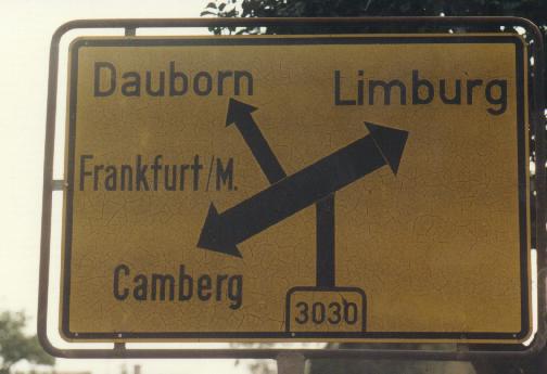
| The picture below shows one of the few signs indicating an L number. |
 |
|
| History: |
Motorways: The first German motorway was opened in 1935 (Frankfurt-Darmstadt).
The current numbering system was adopted in 1975, there was a different system before which was for administrative use only.
It should be noted that the new system, established in 1974, was designed to incorporate the motorways in the GDR, taking into account the possibility of reunification. Zone 1 covered most of the GDR, and zone 7 could easily be extended to cover the southwest. Note that the only numbers in zone 7 in West Germany were 70, 73 and 722 (now 72), though some other numbers were also assigned to planned roads.
There were separate A numbers in the GDR, but these were never signposted. The map below shows an example.
See also
DDR Motorway numbers
|
| Concurrent (multiplex) numbers:
There used to be more roads with two numbers than there are now. See the list below. It may be a new policy to try to avoid double numbers as much as possible. |
| A1/A48 | Changed to A1 around 1996. The western part of the A48 became A64. |
| A1/A61 | Still existing, will probably not be changed. |
| A2/A3 | Changed to A3 around 1993: the western part of the A2 together with the former A430 became A40. |
| A3/A4 | A short section of the Köln ring road. |
| A8/A81 | In 1990, the A81 was rerouted along the A831 (this number is now only used for the small section between the A8 and Stuttgart) and the A8. Formerly a direct route was planned between Kreuz Gärtringen and Dreieck Leonberg. |
| A28/A31 | Originally the road from the Dutch border to Bremen was numbered A28 all the way. When it was opened in 1994, the section between the border and the A31 was renumbered A280 and the number A28 was probably never signposted along the A31. |
| A45/A66 | East of Hanau. |
| A46/A57 | For many years, the A46 was planned between Neuss-Holzheim and Kreuz Neuss-Süd. It is now planned to upgrade the B1 between Neuss-Holzheim and Neuss-West and reroute the A46 via the A57. The number A46 is already indicated on some signs along the A57. |
Bundesstraßen: The Reichsstraßen numbers were probably introduced in the 1930s. The prefix R was used for administration only.
During World War II, existing numbers were extended to Austria and Czechoslovakia and possibly other countries. Examples can be found in the table below and on these fragments of a 1952 Michelin map:
 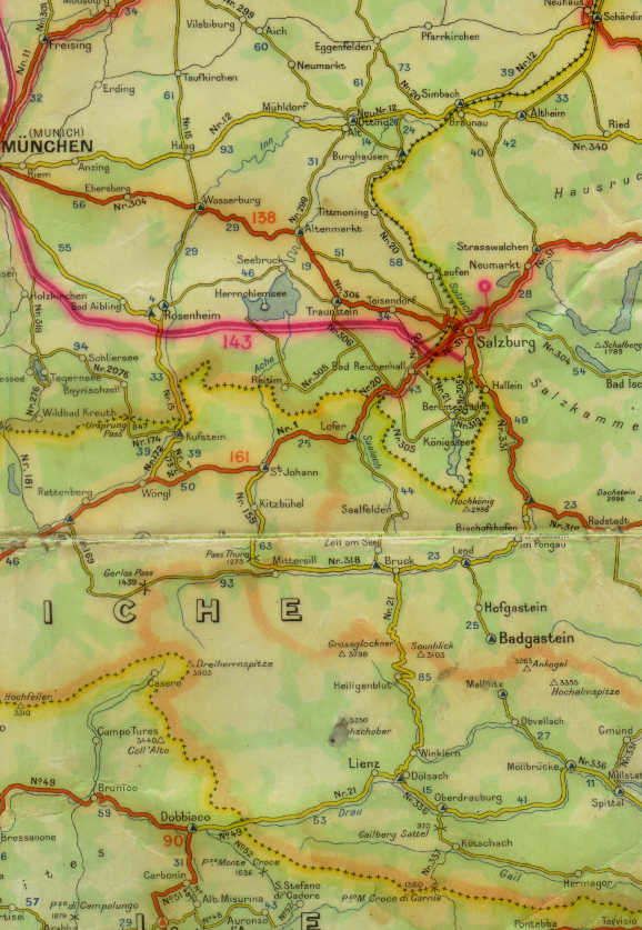
The second fragment is also interesting because of the number 2076 between Schliersee and Bayrischzell (nowadays B307). This is a State highway number. Note the number 276 further west (this is probably an error).
After Germany was split into the FRG (BRD) and GDR (DDR), the numbering system was retained in both countries.
In the BRD they were known as Bundesstraßen with prefix B and in the DDR as Fernverkehrsstraßen (long distance roads) with prefix F.
After reunification they all became Bundesstraßen. Throughout the years they were always signposted in a yellow rectangle with black digits (without R, F or B).
Most numbers have never been changed, though many roads were realigned or replaced by motorways and then downgraded.
Numbers 1-327 were assigned before World War II. Between about 1955 and 1980, many regional roads were upgraded to Bundesstraßen. These were given numbers between 401 and 525. Some numbers outside this range were also used: 340, 378, 388, 399 and 530.
Later, the numbers 400, 532, 533, 535 and 588 were assigned.
Many numbers are not in use anymore because the roads are now in Poland or Russia.
|
| Duplications: Two numbers were used both in the FRG and the GDR: 111 and 250. These duplications were not removed after reunification, and amazingly, two new ones were introduced: 199 and 262.
According to the map Bundesfernstraßen in Deutschland (BMV 1997) all duplications really exist, but there is doubt whether all of them are actually signposted.
It would have been better to use some of the many obsolete numbers, see below. |
| The table below lists obsolete Reichsstraßen/Bundesstraßen numbers and other special cases. |
| Number | Remarks |
| 18 | This number will probably disappear when the last part of the road will be upgraded to the motorway A96 (probably within 10 years). However, a section between Wangen and Lindau still exists parallel to the A96. |
| 24 | Changed to B23 in 1991 |
| 60 | Partly upgraded to A40, rest downgraded to L140 |
| 78 | Now in Poland (15) |
| 111 | Jarmen-Ahlbeck and gap in A111 in Berlin (upgraded to A111 in 2002). According to the 'Verzeichnis der Fern- und Nahziele an Bundesstraßen' (BMV) the latter was the B111a. |
| 114 | Now in Poland (24/133) |
| 116 | Now in Poland (5/8/381) |
| 117 | Now in Poland (4/335/337/340) |
| 118 | Now in Poland (454) |
| 119 | Now in Poland (919) |
| 120 | Now in Poland (404) |
| 121 | Now in Poland (343/364) |
| 123 | Now in Poland (10/179) |
| 124 | Now in Poland (163) |
| 125 | Now in Poland (21) |
| 126 | Now in Poland/Russia |
| 127 | Now in Poland (521) |
| 128 | Now in Poland/Russia |
| 129 | Now in Poland (55) |
| 130 | Now in Poland (7) |
| 131 | Now in Russia (A193/A196) |
| 132 | Now in Poland/Russia |
| 133 | Now in Poland (527) |
| 134 | Now in Poland (511/51/53) |
| 135 | Now in Poland (592) |
| 136 | Now in Poland |
| 137 | Now in Russia |
| 138 | Now in Russia (?) |
| 139 | Now in Russia (?) |
| 140 | Now in Poland (59) |
| 141 | Now in Poland (596/594/591)/Russia |
| 142 | Now in Poland/Russia |
| 143 | Now in Russia |
| 144 | Now in Poland (515) |
| 145 | Now in Poland (38) |
| 146 | Now in Poland (416/420) |
| 147 | Now in Poland (412) |
| 148 | Now in Poland (403) |
| 149 | Now in Poland (401) |
| 150 | Now in Poland (386/381/408) |
| 151 | Now in Poland (383) |
| 152 | Now in Poland (297/367/381) |
| 153 | Now in Poland (374) |
| 154 | Now in Poland (3) |
| 155 | Now in Poland (361/364) |
| 157 | Now in Poland (287) |
| 159 | Now in Poland (171/207) |
| 160 | Now in Poland (11) |
| 161 | Now in Poland (109/152) |
| 162 | Now in Poland (151/152) |
| 163 | Now in Poland (144) |
| 164 | Now in Poland (175) |
| 165 | Now in Poland (102/107) |
| 177 | Formerly Dresden-Meißen-Radeburg-Pirna |
| 199 | Niebüll-Kappeln and Burow-Anklam (ca. 1993, B199a according to the 'Verzeichnis der Fern- und Nahziele an Bundesstraßen' (BMV) |
| 204 | Changed to L127/L316 in 1994 |
| 250 | Wanfried-Creuzburg and Querfurt-Eckartsberga |
| 262 | Mendig-Mayen (connection A61-A48) and Schiersteiner Straße in Wiesbaden |
| 302 | This used to be the road between Amberg and Sulzbach-Rosenberg. In the 1950's, it became part of the B85 which was rerouted via Pegnitz to avoid a military restricted area. |
| 303 | This is probably the road number which was most often changed.
Originally it linked Mitterteich with Cheb in the Czech Republic (then Czechoslovakia).
Then this became the B15 and the original B15 between Hof and Mitterteich via Wunsiedel became the B303.
Around 1955 the section between Hof and Wunsiedel was downgraded and the road Bad Berneck-Wunsiedel was given the number instead.
The B15 was rerouted via Selb to Hof and the B303 was extended to the Czech border (getting its old route back between Mitterteich and the border).
In the early 1960's it was extended from Bad Berneck to Unter-Rodach near Kronach.
Later it was extended further to Gochsheim near Schweinfurt.
Around 1970 the section east of Marktredwitz was rerouted more directly to Cheb via Arzberg. The old B303 northeast of Mitterteich became the B299.
|
| 325 | Now in Poland (8) |
| 327 | This was the highest main road number assigned before World War II. Originally it ran from Koblenz to Saarburg. The section between Reinsfeld and Abtei is interesting: around 1960, the B327 was rerouted to Nonnweiler, and the section west of Abtei was renumbered B407. Later, the B327 was decommissioned south of Abtei, and because a more logical ending of both the B327 and the B407 was at the A1, the section between Abtei and the exit Reinsfeld of the A1 was given its original number B327 again. |
| 331 | This number was assigned in Austria during the war. It ran from Salzburg to Klagenfurt. |
| 340 | This number was assigned in Austria during the war. It ran from Simbach to Wels and possibly beyond. After the war, only a very small section in Germany remained. The Austrian part is now the B141/B148. |
| 347 | This number was assigned in Czechoslovakia during the war. It was later changed to 24 and in the late 1990's to 230. |
| 400 | When Germany was split into the FRG and the GDR, part of the motorway between Eisenach and Bad Hersfeld had to be closed. Between Wommen and Wildeck-Obersuhl, the E70 followed a detour via Wölfterode. This road was named B400 when the new European road numbering system was introduced. This was an appropriate number: it was part of the E40 linking two parts of the A4 (A4 - E40 - B400). Later the A4 was reconstructed and the B400 between Wommen and Wölfterode became important for traffic on the route Kassel-Eisenach. Therefore it was rerouted to Wichmannshausen where it meets the B27. |
| 408 | Around 1970, this road was upgraded to a motorway which later became the A1-A48. In 1993 the number was reassigned in Niedersachsen. |
| 409 | Downgraded to L16 around 1993 |
| 425 | Changed to B319 around 1993 |
| 429 | This road was originally numbered B49a. In 1975 it became the A480. A few years later, it was changed to B429. In 1986, it became B49 when the old B49 was decommissioned to L3451. This is probably the only road whose number was changed three times in only 11 years. The number B429 is still in use for the western part of the ring road around Gießen. |
| 479 | The southern section Ense-Arnsberg was downgraded to L732, and the northern section Ense-Werl was changed to B516. |
| 490 | This number disappeared in 1992, when the last part of the road was replaced by the A39. |
| 524 | To be upgraded to A38 (2005). |
| 530 | Only existed for about 20 years, from 1975 to 1995. Formerly B72a. Currently L24. |
| 535 | The latest new number, introduced ca. 1998 |
| 588 | Currently the highest B number in Germany, introduced ca. 1990 (Eggenfelden-Winhöring). It may have been derived from 388. |
Sources and links: various maps and atlases, personal experience
Official sites:
- Bundesministerium für Verkehr
- Bundesanstalt für Straßenwesen
- AIS Downloadseite: pictures of road signs
- Bayern (Bavaria) route list
Specific roads:
- A1
- (gegen) A4 Lückenschluß
- A7
- Keine A20
- A22 jetzt
- A33/B68
- A31
- Keine A39
- A40 History
- Stopp DüBoDo (A44)
- Bienwaldautobahn (A65)
- A71/73
- A98/A861
- A99
- A100 / Tunnel Ortsteil Britz
- A226
- B213
- B308
Other links:
- Autobahn online
- Patricks Autobahnatlas
- Rippachtal.de Road pictures
- Reichsautobahnen
- Arbeitsgemeinschaft Autobahngeschichte e.V.
- Bundesstraßen route list
- Motorway history
- Motorway intersections
- DDR Motorway numbers
- Pictures of A96 and Austrian A14
- Brian's Guide to Getting Around Germany
Other pages within this site:
- Road sign colours
- Motorway route list
- Exit name changes
- Europe
Pictures:
- Road pictures Germany
|
| Bundesland | Landesstraßen | system/remarks | Kreisstraßen | system/remarks |
| Baden- Württemberg | L[0-9]<2-4> {[a-dn]} |
Numbers match at the borders with Hessen and Bayern
(Lx to Stx). | K[0-9]<4>{a}
Assignment of K number ranges:
Kreise are ordered according to their official administrative codes, for example Stuttgart=08111.
City Kreise (Kreisfreie Städte) are given ranges K9[5-9][0-9][0-9]. |
Alb-Donau-Kreis | K7[34][0-9][0-9] |
| Baden-Baden | K96[01][0-9] |
| Biberach | K75[0-9][0-9] |
| Bodenseekreis | K77[0-9][0-9] |
| Breisgau-Hochschwarzwald | K49[0-9][0-9] |
| Böblingen | K10[0-9][0-9] |
| Calw | K43[0-9][0-9] |
| Emmendingen | K51[0-9][0-9] |
| Enzkreis | K45[0-9][0-9] |
| Esslingen | K12[0-9][0-9] |
| Freiburg | K98[56][0-9] |
| Freudenstadt | K47[0-9][0-9] |
| Göppingen | K14[0-9][0-9] |
| Heidelberg | K97[01][0-9] |
| Heidenheim | K30[0-9][0-9] |
| Heilbronn (Stadtkreis) | K95[56][0-9] |
| Heilbronn (Landkreis) | K2[01][0-9][0-9] |
| Hohenlohekreis | K23[0-9][0-9] |
| Karlsruhe (Stadtkreis) | K965[0-9] |
| Karlsruhe (Landkreis) | K35[0-9][0-9] |
| Konstanz | K61[0-9][0-9] |
| Ludwigsburg | K1[67][0-9][0-9] |
| Lörrach | K63[0-9][0-9] |
| Main-Tauber-Kreis | K28[0-9][0-9] |
| Mannheim | K975[0-9] |
| Neckar-Odenwald-Kreis | K39[0-9][0-9] |
| Ortenaukreis | K53[0-9][0-9] |
| Ostalbkreis | K3[23][0-9][0-9] |
| Pforzheim | K980[0-9] |
| Rastatt | K37[0-9][0-9] |
| Ravensburg | K79[0-9][0-9]; K80[0-9][0-9] |
| Rems-Murr-Kreis | K1[89][0-9][0-9] |
| Reutlingen | K67[0-9][0-9] |
| Rhein-Neckar-Kreis | K4[12][0-9][0-9] |
| Rottweil | K55[0-9][0-9] |
| Schwarzwald-Baar-Kreis | K57[0-9][0-9] |
| Schwäbisch Hall | K2[56][0-9][0-9] |
| Sigmaringen | K82[0-9][0-9] |
| Stuttgart | K95[01][0-9] |
| Tuttlingen | K59[0-9][0-9] |
| Tübingen | K69[0-9][0-9] |
| Ulm | K99[01][0-9] |
| Waldshut | K65[0-9][0-9] |
| Zollernalbkreis | K71[0-9][0-9] |
| Bayern (Bavaria) | St[12][0-9]<3>; St511 | Numbers match at the border with Baden-Württemberg
(Lx to Stx).
This explains the exception St511.
| `Kreis code`[0-9]<1-3>
When a city Kreis (Kreisfreie Stadt) has the same code as the surrounding Landkreis, numbers match at the border (e.g. BA36 in Landkreis Bamberg continues as BAs36 in Stadtkreis Bamberg).
| Aichach-Friedberg | AIC[0-9]<1-2> |
| Altötting | AÖ[0-9]<1-2> |
| Amberg | AM[0-9]<1-2> |
| Amberg-Sulzbach | AS[0-9]<1-2> |
| Ansbach (Landkreis) | AN[0-9]<1-2> |
| Ansbach (Stadtkreis) | ANs[0-9]<1-2> |
| Aschaffenburg | AB[0-9]<1-2> |
| Aschaffenburg | AB[0-9]<1-2> |
| Augsburg (Landkreis) | A[0-9]<1-2> |
| Augsburg (Stadtkreis) | As[0-9]<1-2> |
| Bad Kissingen | KG[0-9]<1-2> |
| Bad Tölz-Wolfratshausen | TÖL[0-9]<1-2> |
| Bamberg (Landkreis) | BA[0-9]<1-2> |
| Bamberg (Stadtkreis) | BAs[0-9]<1-2> |
| Bayreuth (Landkreis) | BT[0-9]<1-2> |
| Bayreuth (Stadtkreis) | BTs[0-9]<1-2> |
| Berchtesgadener Land | BGL[0-9]<1-2> |
| Cham | CHA[0-9]<1-2> |
| Coburg (Landkreis) | CO[0-9]<1-2> |
| Coburg (Stadtkreis) | COs[0-9]<1-2> |
| Dachau | DAH[0-9]<1-2> |
| Deggendorf | DEG[0-9]<1-2> |
| Dillingen | DLG[0-9]<1-2> |
| Dingolfing-Landau | DGF[0-9]<1-2> |
| Donau-Ries | DON[0-9]<1-2> |
| Ebersberg | EBE[0-9]<1-2> |
| Eichstätt | EI[0-9]<1-2> |
| Erding | ED[0-9]<1-2> |
| Erlangen | ER[0-9]<1-2> |
| Erlangen-Höchstadt | ERH[0-9]<1-2> |
| Forchheim | FO[0-9]<1-2> |
| Freising | FS[0-9]<1-2> |
| Freyung-Grafenau | FRG[0-9]<1-2> |
| Fürstenfeldbruck | FFB[0-9]<1-2> |
| Fürth (Landkreis) | FÜ[0-9]<1-2> |
| Fürth (Stadtkreis) | FÜs[0-9]<1-2> |
| Garmisch-Partenkirchen | GAP[0-9]<1-2> |
| Günzburg | GZ[0-9]<1-2> |
| Haßberge | HAS[0-9]<1-2> |
| Hof (Landkreis) | HO[0-9]<1-2> |
| Hof (Stadtkreis) | HOs[0-9]<1-2> |
| Ingolstadt | IN[0-9]<1-2> |
| Kaufbeuren | KF[0-9]<1-2> |
| Kelheim | KEH[0-9]<1-2> |
| Kempten | KE[0-9]<1-2> |
| Kitzingen | KT[0-9]<1-2> |
| Kronach | KC[0-9]<1-2> |
| Kulmbach | KU[0-9]<1-2> |
| Landsberg | LL[0-9]<1-2> |
| Landshut (Landkreis) | LA[0-9]<1-2> |
| Landshut (Stadtkreis) | LAs[0-9]<1-2> |
| Lichtenfels | LIF[0-9]<1-2> |
| Lindau | LI[0-9]<1-2> |
| Main-Spessart-Kreis | MSP[0-9]<1-2> |
| Memmingen | MM[0-9]<1-2> |
| Miesbach | MB[0-9]<1-2> |
| Miltenberg | MIL[0-9]<1-2> |
| Mühldorf | MÜ[0-9]<1-2> |
| München | M[0-9]<1-2> |
| Neu-Ulm | NU[0-9]<1-2> |
| Neuburg-Schrobenhausen | ND[0-9]<1-2> |
| Neumarkt in der Oberpfalz | NM[0-9]<1-2> |
| Neustadt an der Aisch-Bad Windsheim | NEA[0-9]<1-2> |
| Neustadt an der Waldnaab | NEW[0-9]<1-2> |
| Nürnberg | N[0-9]<1-2> |
| Nürnberger Land | LAU[0-9]<1-2> |
| Oberallgäu | OA[0-9]<1-2> |
| Ostallgäu | OAL[0-9]<1-2> |
| Passau (Landkreis) | PA[0-9]<1-2> |
| Passau (Stadtkreis) | PAs[0-9]<1-2> |
| Pfaffenhofen an der Ilm | PAF[0-9]<1-2> |
| Regen | REG[0-9]<1-2> |
| Regensburg (Landkreis) | R[0-9]<1-2> |
| Regensburg | R[0-9]<1-2> |
| Rhön-Grabfeld | NES[0-9]<1-2> |
| Rosenheim (Landkreis) | RO[0-9]<1-2> |
| Rosenheim (Stadtkreis) | ROs[0-9]<1-2> |
| Roth | RH[0-9]<1-2> |
| Rottal-Inn | PAN[0-9]<1-2> |
| Schwabach | SC[0-9]<1-2> |
| Schwandorf | SAD[0-9]<1-2> |
| Schweinfurt (Landkreis) | SW[0-9]<1-2> |
| Schweinfurt (Stadtkreis) | SWs[0-9]<1-2> |
| Starnberg | STA[0-9]<1-2> |
| Straubing | SR[0-9]<1-2> |
| Straubing-Bogen | SRs[0-9]<1-2> |
| Tirschenreuth | TIR[0-9]<1-2> |
| Traunstein | TS[0-9]<1-2> |
| Unterallgäu | MN[0-9]<1-2> |
| Weiden in der Oberpfalz | WEN[0-9]<1-2> |
| Weilheim-Schongau | WM[0-9]<1-2> |
| Weißenburg-Gunzenhausen | WUG[0-9]<1-2> |
| Wunsiedel | WUN[0-9]<1-2> |
| Würzburg (Landkreis) | WÜ[0-9]<1-2> |
| Würzburg (Stadtkreis) | WÜs[0-9]<1-2> |
| Brandenburg | L[0-9]<2-3> | classes: 2-d 3-d 3-d numbers are derived from 2-d numbers by adding a digit at the end.
Zones are determined by the first digit of each number, radiating in clockwise order around Berlin, with zone 1 in the northwest.
| K[67][0-9]<3>{A} Only suffix K6727A
Number ranges are assigned to Kreise in alphabetical order. | Barnim | K60?[0-9]<2> |
| Brandenburg | K6.[0-9]<2> |
| Cottbus | K6.[0-9]<2> |
| Dahme-Spreewald | K61[0-9]<2> |
| Elbe-Elster | K62?[0-9]<2> |
| Havelland | K63?[0-9]<2> |
| Märkisch-Oderland | K64[0-9]<2> |
| Oberhavel | K65?[0-9]<2> |
| Oberspreewald-Lausitz | K66?[0-9]<2> |
| Oder-Spree | K67[0-9]<2> |
| Ostprignitz-Ruppin | K68[0-9]<2> |
| Potsdam | K69?[0-9]<2> |
| Potsdam-Mittelmark | K69?[0-9]<2> |
| Prignitz | K70[0-9]<2> |
| Spree-Neiße | K71[0-9]<2> |
| Teltow-Fläming | K72[0-9]<2> |
| Uckermark | K73?[0-9]<2> |
| Hamburg | R[1-3] | Numbers increase away from the city centre | No other local road numbers |
| Hessen | L[23][0-9]<3> | Most numbers begin with 3 | K[0-9]<1-3> | Numbering per Kreis |
| Mecklenburg- Vorpommern | L[0-3][0-9]<1-2> | classes: 2-d
3-d 3-d numbers are derived from 1-d numbers by adding a digit at the end.
Zones are determined by the first digit of each number:
0 West
1 Centre
2 East
3 Northeast and southeast
Trailing zeroes at the beginning are important: for instance, there are both an L31 and an L031, with L31 a main route, which has derivatives like L311, and L031 derived from the main route L03.
| `Kreis code`[0-9]<1-3> | Bad Doberan | DBR[0-9]<1-2> |
| Demmin | DM[0-9]<1-2> |
| Greifswald | HGW[0-9]<1-2> |
| Güstrow | GÜ[0-9]<1-2> |
| Ludwigslust | LWL[0-9]<1-2> |
| Mecklenburg-Strelitz | MST[0-9]<1-2> |
| Müritz | MÜR[0-9]<1-2> |
| Neubrandenburg | NB[0-9]<1-2> |
| Nordvorpommern | NVP[0-9]<1-2> |
| Nordwestmecklenburg | NWM[0-9]<1-2> |
| Ostvorpommern | OVP[0-9]<1-2> |
| Parchim | PCH[0-9]<1-2> |
| Rostock | HRO[0-9]<1-2> |
| Rügen | RÜG[0-9]<1-2> |
| Schwerin | SN[0-9]<1-2> |
| Stralsund | HST[0-9]<1-2> |
| Uecker-Randow | UER[0-9]<1-2> |
| Wismar | HWI[0-9]<1-2> |
| Niedersachsen | L[0-9]<1-3> | | K[0-9]<1-3>{/[12]} | Numbering per Kreis. | Suffixes only in Kreis Gifhorn |
| Nordrhein- Westfalen | L[0-9]<1-3>{[an]} | | K[0-9]<1-3> | Numbering per Kreis |
| Rheinland- Pfalz | L[0-9]<1-3>{[an]} | | K[0-9]<1-3>{[NS]} | Numbering per Kreis, maximum number 200 |
| Saarland | L[1-3][0-9]<2> | classes: L1..., L[23]... | F4[0-9]<2> | Forststraße |
| Sachsen | S[0-9]<1-3>{a} | S=Staatsstraße
Numbering starts near Leipzig, first numbers increase in southeastbound direction, and then to the southwest.
| K[6-9][0-9]<3>
Assignment of K number ranges: in a number Kxy[0-9][0-9], the digits xy are the last two digits of the official number of the Kreis (for example Dresden=14062).
Numbers beginning with 6 are used in the major cities.
If a K road crosses a Kreis boundary, the last two digits match. For example, the K6205 in Dresden is joined to the K8005 in Meißen. |
Chemnitz (Stadt) | K61[0-9][0-9] |
| Dresden | K62[0-9][0-9] |
| Görlitz | K63[0-9][0-9] |
| Leipzig (Stadt) | K65[0-9][0-9] |
| Plauen (Stadt) | K66[0-9][0-9] |
| Zwickau (Stadt) | K67[0-9][0-9] |
| Annaberg | K71[0-9][0-9] |
| Bautzen | K72[0-9][0-9] |
| Chemnitzer Land | K73[0-9][0-9] |
| Delitzsch | K74[0-9][0-9] |
| Döbeln | K75[0-9][0-9] |
| Freiberg | K77[0-9][0-9] |
| Obervogtland | K78[0-9][0-9] |
| Leipziger land | K79[0-9][0-9] |
| Meißen | K80[0-9][0-9] |
| Mittlerer Erzgebirgskreis | K81[0-9][0-9] |
| Mittweida | K82[0-9][0-9] |
| Muldentalkreis | K83[0-9][0-9] |
| Niederschlesischer Oberlausitzkreis | K84[0-9][0-9] |
| Riesa-Großenhain | K85[0-9][0-9] |
| Löbau-Zittau-Kreis | K86[0-9][0-9] |
| Sächsische Schweiz | K87[0-9][0-9] |
| Stollberg | K88[0-9][0-9] |
| Torgau-Oschatz | K89[0-9][0-9] |
| Weißeritzkreis | K90[0-9][0-9] |
| Aue-Schwarzenberg | K91[0-9][0-9] |
| Kamenz | K92[0-9][0-9] |
| Zwickauer Land | K93[0-9][0-9] |
| Sachsen- Anhalt | L[0-9]<1-3> | Numbers generally increase in southbound direction | K[12][0-9]<3> | Numbers generally increase in southbound direction |
| Schleswig- Holstein | L1-322 | sequential | K[0-9]<1-3> | |
| Thüringen | L[12][0-9]<3> | classes: L1..., L2... | K[0-9]<1-3> | Numbering per Kreis |