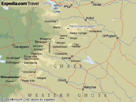
NAPTA |
|
|||||||||||||
A prominent rock projection at
the edge of the ghats and is visible from many places. It has a huge
plateau at its base.
Grade :-
Technical
|
| Reach KALYAN Railway station. |
| Travel by road/bus from KALYAN- MURBAD- TOKAVDE- SAVARNE- MALSHEJ to KHUBI. | |
| Take the bifurcation to KIRESHWAR (A dam is being built here. A broad path goes through a forested gully to TOLAR KHIND near BALE KILLA. (4 Kms) | |
| Down to LAHAVLE (4 Kms) and one can walk on the bus road to PANCHNAI (4 Kms). Ahead a small depression (3 Kms) leads north to the base of NAPTA (2 Kms) via PETHACHIWADI. | |
| Proceed to a col between two peaks of NAPTA. Traverse the southern edge of the main peak. Traverse the southern edge of the main peak. 40 meters of rock climb and very bad scree. Near the top 20 meters of bad scree and reach the top. | |
| To return traverse southwards to the edge of the plateau below NAPTA and descend steeply. The route joins the track of SADHLE Ghat halfway down. Go down to KELEWADI (6 Kms) and to BELPADA (3 Kms). Go across a col to reach SAVARNE (4 Kms) for buses to KALYAN. |

maps.expedia.com