Sauk War Forts of Illinois, Revised.
By Greg Carter, OLRHS, Matt Kestel, OLRHS,
and Pete Payette (American Forts Network).
ę February 9, 2003 by Greg Carter, Matt Kestel, and Pete Payette.
All rights reserved.
[Webmaster's Note: This document is the result of on-going research into numerous forts, stockades and strongpoints erected in the state of Illinois during Black Hawk's War of 1832. There will likely be changes, additions and corrections as further records are unearthed and examined. We are pleased to feature this original research on the OLRHS website!]
Fort Dearborn. Fort Dearborn was a former U. S. Army post located at the mouth of the Chicago River (click here for a sketch of the original fort.) It was released to an Indian agency there in 1828, then reoccupied in 1832 by two companies of the 5th United States Infantry and numerous Illinois Militia members. The fort was built of timber, but the numerous inner buildings were constructed of stone. It was located near the present-day intersection of Michigan Avenue & E. Wacker Drive in Chicago.
Read more about Fort Dearborn by clicking here.
Fort Armstrong. Fort Armstrong was the only active US Army post in Illinois in 1832. It was located at the east end of the Rock Island, in the center of the present-day ôQuad Citiesö, where the Rock River meets the Mississippi. The fort, constructed of wood and stone palisades and blockhouses, obstructed any passage down the Mississippi River. Fort Armstrong was almost as large as Fort Dearborn.
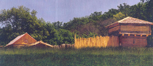 Apple River Fort. The fort at Apple River was constructed in a panic when the Sauk War broke out. It consisted of a single blockhouse, a storage shed, and a cabin surrounded by wooden pickets. Apple River Fort was the only Illinois fort to be attacked by Black Hawkĺs band in 1832. It was located on a bluff just east of the present-day downtown area of Elizabeth. An excellent rebuilt fort is maintained by the Illinois Historic Preservation Agency. The visitor center is located along US Route 20 in downtown Elizabeth.
Fort Wilbourn/Deposit. Fort Wilbourn was located on a bluff overlooking the Illinois River, on the south side. U. S. Army Lieutenant Robert Anderson, who would rise to fame commanding Fort Sumter in 1861, commanded the post. Abraham Lincoln was mustered into his second term of service with the Illinois Militia at this fort. The fort was located on what is today the campus of Illinois Valley Community College in Oglesby.
Fort Horn. Fort Horn was a militia fort overlooking the Illinois River at the mouth of the Little Vermillion River, across from Fort Wilbourn on the North side. The fort was located in present-day LaSalle, called "Illinoistown" at the time.
Fort Johnston. Fort Johnston was a militia fort that overlooked the Illinois River at the mouth of the Fox River, on the south side. It was commanded by and named after U.S. Army Lieutenant Albert Sydney Johnston, who in 1862 commanded the Confederate Army at the Battle of Shiloh. The fort was located above the present-day city toboggan run, west of the intersection of IL Route 23 and IL Route 71 in South Ottawa.
Fort Cribs. Fort Cribs was located near the present-day town of Florid, IL. It was comprised of three corncribs connected with a stockade of wood pickets. Its exact location is still under investigation.
Warnockĺs Blockhouse. This fort was built on a farm near present-day Granville, IL. The exact location is presently under investigation.
Darnellĺs Fort. This fort was built on the farm of Benjamin Darnell. The fortĺs present-day location is in Roberts Township of Marshall County along Sandy Creek. The exact location is still under investigation.
Hartzellĺs Fort. This fort was actually a fortified trading post. It was located on the east side of Front Street in Hennepin, overlooking the Illinois River. The exact location is presently under investigation.
Thomasĺ Fort. This was actually the fortified home of Henry Thomas, on the Galena Road. It was located approximately 4 miles north of present-day Wyanet. The exact location is presently under investigation.
Gumĺs Fort. This was the fortified cabin of John Gum and his family in Hendersonĺs Grove. It consisted of a double cabin with a connected roof, with reinforced doors and windows. The fortĺs present-day location is beneath the Old Courthouse Historic Site in Knoxville, Illinois, on IL Route 150. The Knox County Historical Society maintained the cabin until the mid-1950, when the structure was deliberately burned by an arsonist. Read a seperate article on this fort by clicking here.
McMurtryĺs Fort. This small wooden stockade and blockhouse was built on the William McMurtry farmstead, three miles northwest of Hendersonĺs Grove in section 10 of Sparta Township of Knox County, overlooking Middle Creek. The fort was issued 100 muskets from Fort Armstrong to aid in arming the 45 militiamen stationed there.
 The Stockade Refuge. This fortification was located in the center of Galena on Perry Street. It consisted of a central blockhouse surrounded by a wooden stockade. One corner of the stockade featured a blockhouse; the other three contained fortified houses. This fort, constructed under a proclaimation of martial law, included the fortified home of Colonel James M. Strode. A lawyer and a Galena resident, Strode served as the commander of the 27th Regiment, Illinois Volunteer Militia.
Naperĺs Fort. The fortified trading post of Joseph Naper served as a fort until Fort Payne could be constructed. It was located within the city limits of present-day Naperville, but the exact location is presently under investigation.
Fort Payne. Genrally described as a 100 square foot wooden stockade with two blockhouses, settlers constructed Fort Payne in the center of present-day Naperville. North Central Collegeĺs Mernier Field House sits over the site of the fort.
Fort Clark. Originally a War of 1812-era fort located in Peoria, local settlers refurbished Fort Clark for defense in 1832. It stood at the intersection of Liberty & Water Streets in present-day Peoria, on the west bank of the Illinois River.
Fort Doolittle. Local residents fortified Snell Schoolhouse and renamed it "Fort Dolittle." While no trace of the fort remains today, it was located on 2nd Street between Elizabeth and St. Maryĺs Avenues in present-day Pekin.
Craneĺs Fort. This fort was built in present-day Carroll County. the exact location is under investigation at present.
Fort Dupage. This fort was a 100 square foot wooden stockade with two blockhouses, protected by a 50-man militia company. It was built in present-day Dupage County near Wheaton. The exact location is presently under investigation.
Beckĺs Blockhouse. Built on the farm of John Beck in 1811, he refurbished the structure for defense during the Sauk War. While the structure was originally located near Edwardsville, the exact location is presently under investigation.
Littleĺs Fort. This fort was erected to protect the settlers near present-day Waukegan. The exact location is unknown and is presently under investigation.
Bartlettĺs Fort. This fort was erected in present-day Pin Oak Township of Madison County. The exact location is unknown and is under investigation at present.
Bartholomewĺs Fort. This fort was a fortified farmhouse 5 miles from Pleasant Hill. The exact location of this fort is under investigation.
Hillĺs Fort. This fort was located along the shore of Lake Carlyle in present-day Carlyle. Its exact location is presently under investigation.
Greenĺs Fort. The fortified home of Mr. James Green was located on the east bank of Shoal Creek, at the fork of the east and west branches, 8 miles southwest of Greenville and approximately 2 Ż miles east of Pocahontas. The site can be viewed from the north/eastbound lane of Interstate 70/US Route 40.
Pattonĺs Fort. This fortification was located on the farm of Mr. James Patton, near Lexington. Little more than a converted farm residence, the structure ramined a fort until 1840, when it was converted back into a farmhouse. The McLean County Historical Society maintains the site today-- although nothing remains of the original structure. The fort has not been reconstructed.
Fort Nonsense. This fort was built on the homestead of Mr. Jesse Cook, which stood on a bluff overlooking the west side of the Des Plaines River in Joliet. The fort was near the ôold settlerĺs caveö, used for protection against Indians in the early settlement of the area. Fort Nonsense stood approximately 100 square feet in size, with a blockhouse on the northeast corner. The fort's serious shortcomings gave rise to the nickname ôNonsenseö-- it lacked a water source, provisions, and adequate armament. Further, locals constructed the fort on the west side of the Des Plaines River, not the east side, where all other local forts were being built.
Higginbothamĺs Fort. This fort was erected on the home of Mr. James Higginbotham where present-day Cass Street crosses Hickory Creek in Joliet, on the west side of the creek.
Father Beggĺs Fort. This fort was erected using the logs from the barn and shed of Father S. R. Beggs, a Methodist preacher residing in Reedĺs Grove (present-day Plainfield.) The exact location of this fort is presently under investigation.
McKeeĺs Fort. This was a fortified homestead in Will County. The exact location is presently under investigation.
Campbellĺs Fort. This was a fortified homestead in Will County. The exact location is presently under investigation.
The Carthage Fort. This fort was essentially a fortified settlerĺs home located in Carthage. In 1839, the structure was made over in native limestone and converted into a jail. Here, on June 27, 1844 a lynch mob killed Mormon Prophet Joseph Smith and his brother Hyrum. The Old Carthage Jail Historic Site preserves the building today. It is located in downtown Carthage on US Route 136 near Courthouse Square.
Read more about the Old Carthage Jail by clicking here.
Fort Edwards. This fort was originally erected in 1812. It fell into disrepair and was largely ruined by 1824, but was refurbished for defense in 1832. A stone obelisk marks the site of the fort today. It stood on a high bluff overlooking the Mississippi in the present-day town of Warsaw, just west of the Great River Road.
Crossroads Fort. This fort was located in McDonough County near present-day Macomb. The exact location is under investigation.
Henlineĺs Fort. This fort was built on the farm of John Henline, near the present-day town of Lawndale. The exact location is presently under investigation.
Dixonĺs Blockhouse. This was the fortified tavern located at John Dixonĺs Ferry on the Rock River. It served as headquarters for General Henry Atkinson during the Sauk War. Tody, a modern log structure located on or near the original cabin site in Dixon may be seen at the intersection of N. Galena Avenue and Lincoln Statue Drive, under the IL Route 2 Bridge on the north side of the Rock River in Dixon.
Read more about Dixon's Fort by clicking here.
Kelloggĺs Fort. This was the fortified cabin of Oliver Kellogg, an early settler of Stephenson County. It was located near the present-day town of Pearl City at the intersection of Dublin Road and Rees Road in Stephenson County.
Kelloggĺs Grove Fort. This fort was a settlerĺs cabin in Kelloggĺs Grove, used to fight off an Indian ambush that occurred there in June 1832. The cabin was located near the battlefield of Kelloggĺs Grove, at the intersection of Kent Road and Blackhawk Road in present-day Stephenson County.
Hubbardĺs Fort. This stockade was erected in 1818 and maintained by the American Fur Company. It stood on the bluff overlooking the Illinois River in the present-day town of Marseilles.
The Fort at Lockport. The settlers in the area of present-day Lockport, although not described by name, built this fort. It was built on the east side of the Des Plaines River between Big Run Creek and Fraction Run Creek.
Fort Winnebago. Not to be confused with the U. S. Army fort of the same name, this fort was erected in 1827 as protection for the settlers of Ottawa during the Winnebago War. It stood approximately two miles south of Fort Johnston in 1832.