|
|
 |
K2
|
|
 |
Where is K2?
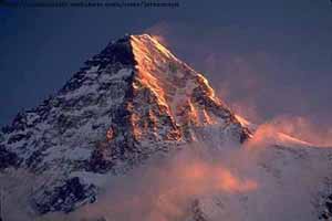
K2 straddles the border between China and Jammu and Kashmir in a territory currently claimed by Pakistan. Its name is derived from the fact that it is the second peak (of 35) in the Karakorum Range of the western Himalayas. In 1861 the mountain gained its other well-known (though unofficial) name: Mount Godwin-Austen. Henry Haversham Godwin-Austen, a British soldier and topographer, was the second European to visit the area and research the mountain. Many local names are also used to identify the peak, including Chogori, Lambha Pahar, Dapsang, and Kechu (K2).
You may be asking yourself, "Why is this company called 'K-2' but the mountain's name is 'K2'? Where did that hyphen come from?" Well, we LIKE the hyphen. The hyphen makes us happy. The hyphen is not leaving. That's our story and we're sticking to it.How tall is this thing?
K2 rises 28,250 ft (8611 m) and is the second tallest mountain the world, behind Mount Everest which rises 29,028 ft (8848 m). A March 1987 measurement of K2 indicated that it might be higher than Everest, but later that year, Everest was remeasured by a similar method and found to indeed be 778 ft (237 m) taller. (We don't like to talk about Mt. Everest around here, but if you absolutely must have more information, you can read one man's account of the 1994 American Expedition to the peak.)
Tell me about the weather
Above 15,000 ft (4600 m) the temperature rarely rises above freezing, even in the summer. The snow cover is permanent above 16,000 ft (4900 m) and the winter snow line begins at approximately 4,000 ft (1200 m). Little or no vegetation grows above the permanent snow line, and animal life is primarily below the 12,000 ft (3700 m) line.
![]()