|
Defenses of Mill Springs,
December 1861
Map by Lt.-Col. Moscow Carter, 20th
Tennessee Infantry
This map is part of the Moscow Carter Diary, courtesy the Carter House Museum,
Franklin, Tennessee. Used by permission, all rights reserved.
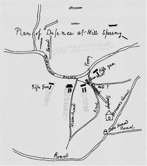
Salient features of this map include:
 Four gun positions around Mill Springs. It is somewhat unclear
whether these positions as shown here were meant to guard against attack from the south,
or to command the river and shoot across it. On the original map, three of the gun
positions appear to be situated to cover ravines to the south. However, assuming the
dark rectangles at the upper end of the guns indicate earthworks, the guns should then be
firing toward the river. The features that look like ravines may then actually
indicate high ground. The actual ground as it appears today would seem to favor the
latter interpretation. At any rate, no such gun positions have been identified along
the probable location of the Confederate works south of Mill Springs (which should be
further south than the positions shown on the map, anyway). Of course, it must be
noted that this is a sketch map, not to scale, and it may be reading too much into the
original to place such a strict interpretation on it. Note also that the rifle guns
were placed at the outside, where they would presumably have the greatest range.
These may have been the two Parrott guns that one source notes were found in the
abandoned Beech Grove camp following the Confederate retreat, perhaps belonging to the
Tennessee Harding Artillery (see the Weapons page). Four gun positions around Mill Springs. It is somewhat unclear
whether these positions as shown here were meant to guard against attack from the south,
or to command the river and shoot across it. On the original map, three of the gun
positions appear to be situated to cover ravines to the south. However, assuming the
dark rectangles at the upper end of the guns indicate earthworks, the guns should then be
firing toward the river. The features that look like ravines may then actually
indicate high ground. The actual ground as it appears today would seem to favor the
latter interpretation. At any rate, no such gun positions have been identified along
the probable location of the Confederate works south of Mill Springs (which should be
further south than the positions shown on the map, anyway). Of course, it must be
noted that this is a sketch map, not to scale, and it may be reading too much into the
original to place such a strict interpretation on it. Note also that the rifle guns
were placed at the outside, where they would presumably have the greatest range.
These may have been the two Parrott guns that one source notes were found in the
abandoned Beech Grove camp following the Confederate retreat, perhaps belonging to the
Tennessee Harding Artillery (see the Weapons page).
The Corn Mill at Mill Springs, with the creek feeding it,
and Brown's House.

|

|
| Reconstructed Mill Springs Mill |
Thompson Brown House, Mill
Springs |
The open lines and rectangles at Beech Grove (above
and around the map title), which may be renderings of the Beech grove earthworks, under
construction.
|