Palmerston North Electric Power Station Inc.
![]()
Where are we?
![]()
1. The Power Station is a very distinctive large brick landmark that is located in Keith Street, in the city of Palmerston North, which in turn is the Manawatu region of the lower North Island of New Zealand. It has no on-site mailbox, and its actual street number has therefore, not been looked into at this stage. Once you find Keith Street, it is RATHER hard not to spot the only huge old red brick building in the street.
![]()
2. The Power Station's neighbours and reference points within Palmerston North, are that it adjoins Terrace End Cemetery, and it overlooks the city's SPCA facility, which in turn fronts Napier Road (State Hwy 3). This road in turn leads out of the city in the direction of Hawkes Bay.
![]()
3. View Multimap.com's interactive map of our region of New Zealand
![]()
4. This old NZ Automobile Association map (below) shows a more detailed view of Manawatu. The general location of the Power Station is on the right side of the map is more or less about half way between the first 'A' in "Whakarongo" and the 'N' in "Palmerston".
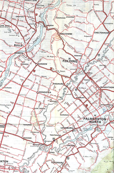
![]()
5. The lower map shows the street location of the Power Station from a 1998 Minimap of Palmerston North and district. The Power Station site, which is marked by a circle around an 'x', is located where map references 'R' and '4' bisect. Palmerston North Airport is partially obscure at the top left of the map, while the central city is obscure on the lower left of the map. Until the mid-1960s, the railway line (shown as a black line) passed close to the Power Station to travel to the old central city railway station site down Main Street East (i.e. the continuation of Napier Road).

![]()
Last Updated: 27/7/2003