The History and Evolution
of Road Maps
December 2005
Geography 20H Final Report
Note to the Reader: A web page format has been chosen for
this report to ensure that the graphics of maps are represented in the clearest
detail possible without compromising space for the size of a sheet of
paper. Thank you for your
understanding.
Abstract: Over time, the focus and
presentation of road maps have changed dramatically. From the 1680s through today, some items
remain important to display on the map (such as town names), but many other
features have been added or removed.
This can be proved by studying road maps from the past through the
present and analyzing the differences.
The study of road maps is important not just to people lost on highways
but also to geography at large and how Americans choose to represent our
landscape on two-dimensional surfaces.
Key
Words: highways, roads, map, history, paper, Internet, driving, design
Ever
since roads began to appear, mankind has looked for the ultimate way to
represent how its transportation system is laid out so that travelers and
observers can see large sections at once in an organized fashion. For much of human history, roads and
paths were laid out based on the shape of the land it traveled over, and often
attempted to create the shortest distance between two points of interest
(cities, etc.). If a mountain
happened to impede the quickest flow of travel, then the road was built around
it in the most convenient place.
Roads have also mirrored the growth of civilization; for each new
technological era, new ways were developed to build, maintain, and map roads.
For
this study on the history of highway maps, I will be analyzing the growth and
expansion of American roads, which is directly proportional to the growth,
expansion, and sharpening of the American road map. Over time, roads have become wider,
smoother, and safer, while maps have become more detailed, more precise, and
more interactive. Road maps still
maintain many of the same features today as when they were first produced, but
the additional information now available with an overview of the highway system
from point A to B can prove invaluable in fully understanding the American
landscape.
Beginning
with
Finding
accurate maps of roads during this time was rather difficult. First of all, the roads were never
permanent and could often change depending on floods or other events. What most people were looking for in
maps were landmarks and land ownership, as that would give the observer as much
information as they needed while traveling in the largely rural colonies. The following picture shows an excerpt
of a 1687 map of the city of  [2]
[2]
In this map,
the city of  [3]
[3]
This map is a
good representation of modern-day Center City Philadelphia from over 300 years
ago. Broad Street remains as today,
with its intersection at High Street (now
Beginning in
the late 1700s and continuing through the 1800s, the paths between places
became much more important as the vast tracts of land from the 1600s were split
into towns and homesteads. This map
is from 1792, and shows a much larger area than the 1687 map, but is
approximately the area that will be displayed in the rest of the maps.  [4]
[4]
This
map is beginning to show the makings of modern southeastern
In
terms of hand-drawn detail (since the map is still hand-drawn), the city of
Philadelphia appears to have expanded considerably to the northeast and south,
Several different types of building can also be found on the map, including
churches (two can be found between West and East Marlborough in the lower-left
corner) and other landmark buildings, simply marked with black rectangles. There is not, as of yet, a standard way
of writing place names; the name for
Although
the 1792 map showed trails and paths, there were still few ways to travel
quickly between destinations, as the best ways to travel were still either on
horses or boats. This continued
throughout the 1800s, as paths were improved but the total travel time was
still rather excessive. Once the
automobile was invented and made affordable for the average American, the need
for an improvement in the transportation system became apparent. However, it would still take several
decades for the car to become
The map traces
railroad lines because of the “R. R.” designations along most of
the lines, but also because the lines connect cities directly in a way the
roads today do not do exactly. Yet
how the railroad lines were laid meant a lot to the future roads that would complement
and then overtake railroad lines as forms of transportation. For example, US Route 202 today largely
follows the line connecting Doylestown in
This map
essentially illustrates how the country was about to change with the arrival of
the automobile into average American life.
The next few decades would completely reshape the American
transportation network, but thanks to the lines laid out by the railroad
companies, roads would have a basic framework to follow as they slowly spread
out across the country. The next
few maps will demonstrate this postulate.
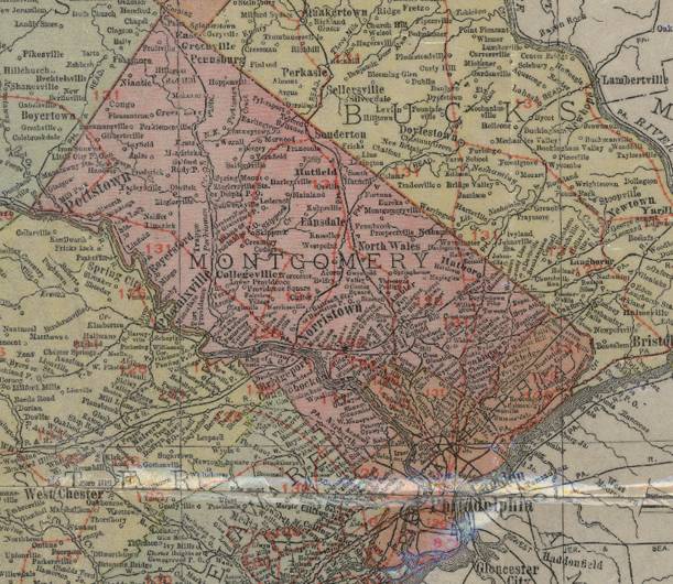
During the
1930s and 1940s, road maps became indispensable for traveling longer
distances. Maps were often put out
by oil companies, marking their own stations on the map. This map is from AAA (the American
Automobile Association) from 1947.
This is the
first of what can be called “modern highway maps.” It is clear that over the past thirty
years, massive amounts of construction and upgrading of old paths was done on
these new roads. The
Another
example of a map from this time is this map from the United States Geological
Survey in 1955. Roads have become
important enough by this time that even maps that used to be mainly topological
must now include roads to provide context for the geological features.

Interestingly,
due to the colors chosen on this map, the roads’ pinkish color appears to
overshadow the intended topological lines in brown. This is another testament to how
important roads had become to the American society and how all sorts of maps
now reflected the changing landscape.
Another interesting addition to this map is the presence of the
Pennsylvania Turnpike and Northeast Extension, running north from outside of
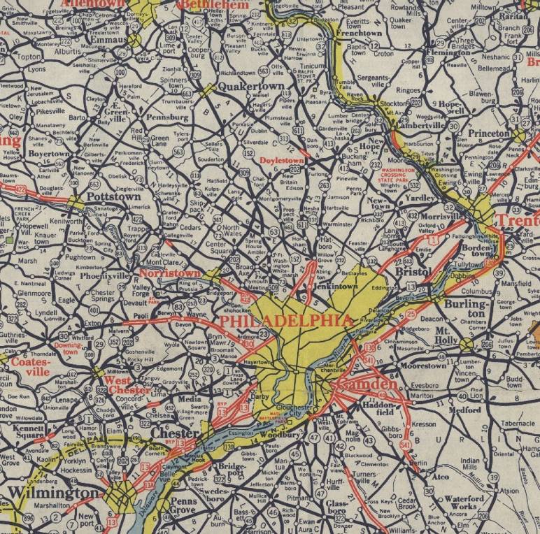
The end of the
20th century brought about the introduction of the interstate
highway system along with refinements of how maps were drawn, labeled, and
presented. The Eisenhower
Interstate Highway System was initially proposed and developed for national
defense purposes, but quickly became popular for all types of travelers. The impact of the interstate highway
system is evident from this 1975 USGS map.

This map,
while not specifically for roads, illustrates perfectly the goal of roads: to
connect major urban areas. Several
interstate highway designations have been added to this map, including I-76 and
I-95, but the actual physical roads are not very clear because they mostly run
through urban areas. These next
maps from the late 1980s and 1990s show the current state of paper road maps in
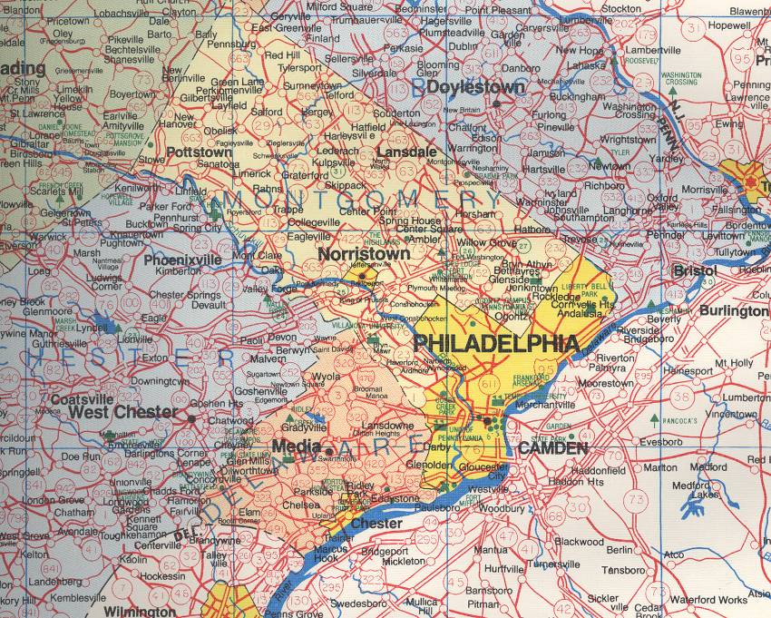
This Champion
Maps map from 1989 is interesting in a number of ways. Note the very large circles used to
label state routes, which can create some confusion (in particular, the
confluence of PA 252, 352, 452, and 320 outside of

The state highway
maps have finally brought clarity and order to a rather mishmashed
This
is the beginning of a reflection of the need for different levels of detail in
a certain area. The first map is
useful for larger and longer trips, while this would be more useful for travel
within the
These
next few pictures reveal ways that even within one decade (the 1990s), the art
of road map making could be improved.
First is a picture for comparison’s sake from 1991 of the USGS
topographic state map.

Besides
the different towns, cities, roads, and bodies of water, the only other marked
landmarks are the three airports in a line from Southwest Philadelphia to
Northeast Philadelphia to

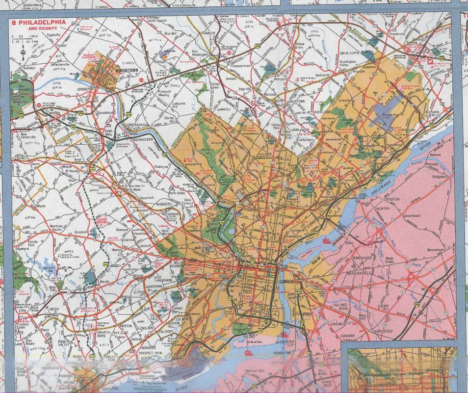
Maps
around this time appeared to begin to be obviously computer generated. The PA keystone shields on top of


While
the maps still look official, there is something about the different fonts of
words and colored interstate signs that gives a more
“user-friendly” look to these two maps as opposed to previous
ones. After all, the point of maps,
ever since they were introduced, is to depict as accurately as possible how
roads interacted with the landscape, the cities they connected, and each
other. Clearly, the 2003 maps do a
good job of showing all three; interchanges such as I-476 (now complete!) and
US 1 outside of Marple west of
Over
300 years, the mapping of America transformed from hand written diagrams of
land ownership and 10 by 20 cities to an elaborate process involving space
management, color, and the real landscape as much as possible. Since transportation has changed, maps
have changed along with it. Maps
are no longer simply for people attempting to diagram the landscape, but are useful
tools in mapping the shortest distances between two points.
In
some ways, the story is done. Paper
maps are still being refined as both new graphic design techniques and new
roads appear. However, a much
larger force may soon render paper maps completely obsolete. The idea of mapping through the Internet
was born out of the wish for interactivity in mapping and directions. What if a program could compute the
fastest way between two points on the landscape using roads? Several services appeared soon after the
Internet became public knowledge offering maps and driving directions online,
such as Mapquest.

Note
the zoom function available on the left side of the map. This solves one of the oldest problems
of maps: how to get the exact amount of detail necessary for the map in
question. This eliminates the need
for maps for several specific areas as well as overview maps. Notice also how these online maps have
taken many cues from paper maps in terms of the colors of different types of
roads and road labels. This is to
ensure that someone will not feel lost using the new technology, as these
online maps are designed to look mostly like the paper ones but have many more
features.
There
are also stand-alone computer programs that do not require an active Internet
connection. One of the most famous
is Microsoft Streets and Trips, which has many of the same features as online
computers. The following is a
screenshot from Streets and Trips showing a simulated trip from
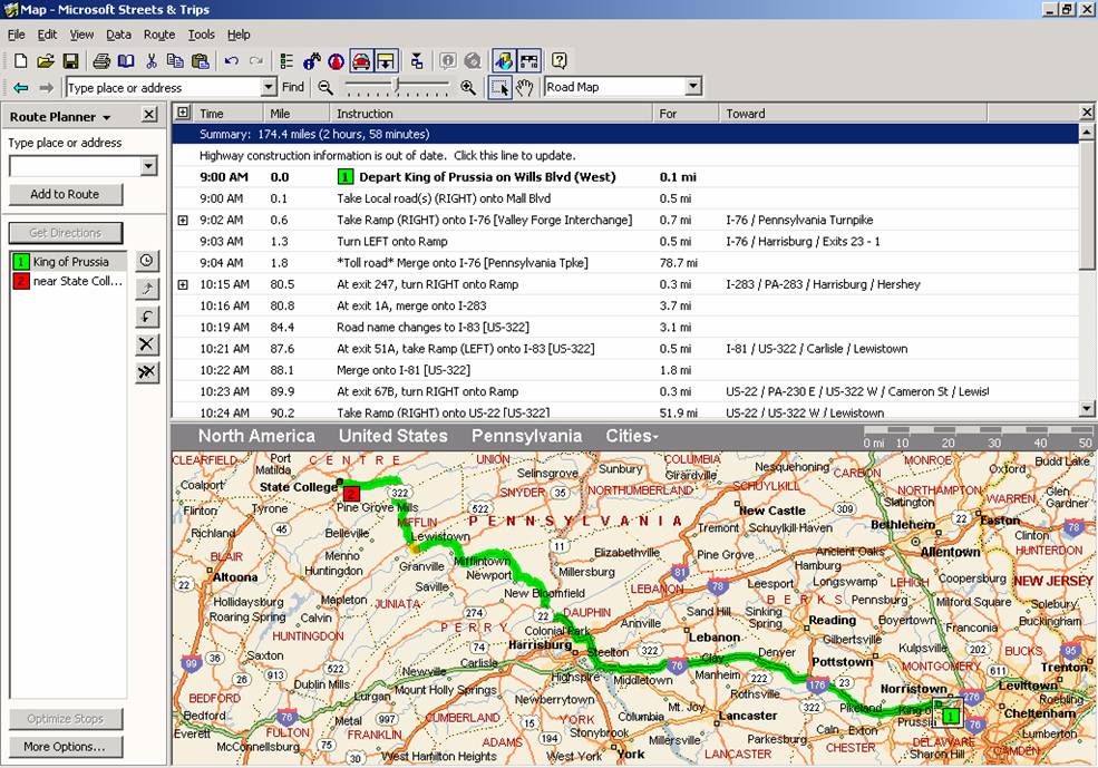
Unlike
paper maps, you can “ask” a computerized map program to calculate
all sorts of details about your journey for you, including mileage, estimated
time, and even turn-by-turn directions.
Note the yellow patch around Lewistown where the computer is detecting
construction along US 322. This
would be simply impossible with any sort of paper-based map.
The
final frontier in map making is based on satellite imagery. If the roads’ exact locations do
not need to be estimated, then they exactly represent real life, one of the
goals of true map making. Several
programs have been developed to overlay map data with satellite imagery,
including Google Earth from Google, Inc.

Google
Earth can not only give exact maps of certain areas, but also driving
directions to marked places. The
technology is at times frightening, but also fascinating that this may
completely replace paper maps within a few years. For example, this is a view of my house
at a supposed “altitude” of 1000 feet.
 [19] The
satellite image is so clear that you can see the car in my driveway. This final graphic is a view of State
College and the
[19] The
satellite image is so clear that you can see the car in my driveway. This final graphic is a view of State
College and the  [20]
[20]
This
technology of satellite mapping is exploding and providing the perfect base for
GIS (geographic information systems).
All sorts of overlays onto this map have already been created for public
usage, such as population and crime data.
As more and more information becomes digitized, more and more ways of
handling and analyzing the information will be needed. This is where computer-based mapping
will play a very important role.
The history of
road maps mirrors the history of vehicles.
Both started out as very crude ways to get somewhere and understand
where you will be going. Over time,
however, both improved tremendously.
Today, we have vehicles that can do nearly everything except drive
themselves and maps that can show nearly everything except live images of
traffic. I am sure that someone is
working on both of these current limitations right now, but even with
limitations, it is remarkable to trace the rapid refinement of map making. The amount of detail now present on
computerized maps makes it possibly to find nearly anything, not just the
quickest way between two points. I
know that mapping technology will continue to grow in new and unforeseen ways
as roads continue to evolve during the 21st century.
Figures:
|
Title of Map |
Call Number (if from Map
Library) |
Company/Organization |
|
|
G3820 1991.A4 |
USGS |
|
Champion Map of |
G3820 1989.C4 |
Champion Maps |
|
State of |
G3820 1975.U5 |
USGS |
|
State of |
G3820 1955.U5 |
USGS |
|
|
G3820 1911.R3 |
Rand McNally |
|
“Map of the State of |
G3820 1792.H6 (reprinted 1894) |
Reading Howell |
|
“A Map of the Improved
Part of the |
G3820 1687.H6 (reprinted 1894) |
Thomas Holmes |
|
Official Transportation and
Tourism Map |
G3821.P2 2003.P4 |
State of |
|
|
G3821.P2 1998.A4 |
Alfred B. Patton, Inc. |
|
Official Transportation and
Tourism Map |
G3821.P2 1991.A4 |
State of |
|
|
G3821.P2 1947.A6 |
AAA |
|
|
|
Mapquest |
|
|
|
Microsoft |
|
Earth |
|
Google |
|
|
|
Google |
|
|
|
Google |
References:
