|
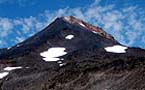
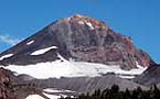
 Located
at the northern end of the Oregon Cascades, Mt. Hood is a jewel among
the Oregon volcanic summits rising to 11,237 feet. With eleven glaciers
carving their path down its steep slopes, Hood's beauty has been sculpted
over hundreds of thousands of years by fire and ice. Just an hour from
metropolitan Portland, the city's skyline is dominated by Mt. Hood's lofty
presence. Mt. Hood is among the most climbed alpine summits in the world. Located
at the northern end of the Oregon Cascades, Mt. Hood is a jewel among
the Oregon volcanic summits rising to 11,237 feet. With eleven glaciers
carving their path down its steep slopes, Hood's beauty has been sculpted
over hundreds of thousands of years by fire and ice. Just an hour from
metropolitan Portland, the city's skyline is dominated by Mt. Hood's lofty
presence. Mt. Hood is among the most climbed alpine summits in the world.
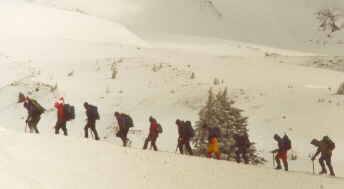
The traditional route
to Hood's summit starts at historic Timberline Lodge perched at 6,000
feet. We started our climb up the ridge that runs along side the ski area
above the lodge. After gaining nine hundred feet to the level of Silcox
Hut, the sky was clear but a stiff wind was already chilling exposed skin
as we moved forward under the heavy loads of our packs which carried everything
we would need to survive the night on the mountain.
 Slowly
we ascended to an elevation of 8,000 feet near the highest point of the
Palmer Glacier. There we searched about the exposed rocky ridge until
we found a camp frequented by previous climbers who had constructed a
low stone wall as a wind break. Feeling we were climbing in the foot steps
of historic mountaineers of the past, we erected our geodesic tent with
some difficulty in the wind which had grown to a howling gale. After a
spartan dinner we sealed up in our protective life pod to rest for a summit
bid in the morning. Slowly
we ascended to an elevation of 8,000 feet near the highest point of the
Palmer Glacier. There we searched about the exposed rocky ridge until
we found a camp frequented by previous climbers who had constructed a
low stone wall as a wind break. Feeling we were climbing in the foot steps
of historic mountaineers of the past, we erected our geodesic tent with
some difficulty in the wind which had grown to a howling gale. After a
spartan dinner we sealed up in our protective life pod to rest for a summit
bid in the morning.
At 4:00 a.m. we awoke
and geared up in bone chilling wind. The prospect of getting up well before
dawn in cold that numbs your fingers in seconds as you perform simple
tasks like tieing boots and strapping on crampons is enough to test the
metal of most anyone. However, it is something you must work through for
yourself each and every climb. The highest summit cannot be attained without
first taking those first steps. The wind was gusting up to fifty miles
per hour, and our preparations were hastened by the need to start climbing
to warm ourselves. The route above Palmer Glacier progressed up steeper
grades with only the crunch of my crampons on ice, the whistling of my
breath, and a wailing wind to keep me company. As uncomfortable as I was,
something began to stir in my soul with each step.
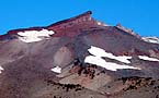
 Two hours of climbing brought
us to the base of Crater Rock, which is a remnant of an ancient crater
wall protruding from the south side of the mountain. As the angle steepened
we worked up to 10,000 feet and finally gained the Devil's Kitchen, a
heated volcanic rock dome pocked by sulfurous geothermal fumaroles that
expose the dome even during winter conditions. A smell like burnt gun
powder cut the crisp air and seared our panting lungs. From this point
Steel Cliff towered to the east, and the route turned left up the Hog
Back, a snow ridge several hundred feet in height. The angle grew steeper
as we ascended the Hog Back. This snow ridge has migrated back and forth
across the face of the mountain through recorded history driven by weather
patterns spanning decades. At the top of the ridge we joined the common
traffic jam of other mountaineers roping up to ascend or gearing down
after descending back to the safety of the ridge. We continued up the
steep wall of ice hewn steps following a gradual traverse back to the
right toward the Pearly Gates. Two hours of climbing brought
us to the base of Crater Rock, which is a remnant of an ancient crater
wall protruding from the south side of the mountain. As the angle steepened
we worked up to 10,000 feet and finally gained the Devil's Kitchen, a
heated volcanic rock dome pocked by sulfurous geothermal fumaroles that
expose the dome even during winter conditions. A smell like burnt gun
powder cut the crisp air and seared our panting lungs. From this point
Steel Cliff towered to the east, and the route turned left up the Hog
Back, a snow ridge several hundred feet in height. The angle grew steeper
as we ascended the Hog Back. This snow ridge has migrated back and forth
across the face of the mountain through recorded history driven by weather
patterns spanning decades. At the top of the ridge we joined the common
traffic jam of other mountaineers roping up to ascend or gearing down
after descending back to the safety of the ridge. We continued up the
steep wall of ice hewn steps following a gradual traverse back to the
right toward the Pearly Gates.
 At 10,800 feet we came to the Bergschrund, a huge crevasse which
pulls away from the steep crater head wall as each season progresses.
We passed the Bergschrund on the left and started up the very steepest
part of the entire climb. A fall there would be a fatal error, and so
we negotiated each step up the icy wall with utmost caution, sinking our
ice axes securely into the frozen crust, and stamping crampons in with
every step to secure our footing. The climbing was slow and exhausting.
At 10,900 feet we passed upward through the Chute, a steep gully totally
encrusted in rime ice. Above that we came to the Pearly Gates, which are
rock formations totally encrusted in wind sculpted rime ice. Just another
few hundred feet above that we saw the summit ridge come into sight. Our
steps came slower as we climbed higher, but we knew our goal was drawing
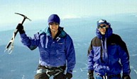
ever nearer. At last one foot at a time we gained the summit at 11, 240
feet! At 10,800 feet we came to the Bergschrund, a huge crevasse which
pulls away from the steep crater head wall as each season progresses.
We passed the Bergschrund on the left and started up the very steepest
part of the entire climb. A fall there would be a fatal error, and so
we negotiated each step up the icy wall with utmost caution, sinking our
ice axes securely into the frozen crust, and stamping crampons in with
every step to secure our footing. The climbing was slow and exhausting.
At 10,900 feet we passed upward through the Chute, a steep gully totally
encrusted in rime ice. Above that we came to the Pearly Gates, which are
rock formations totally encrusted in wind sculpted rime ice. Just another
few hundred feet above that we saw the summit ridge come into sight. Our
steps came slower as we climbed higher, but we knew our goal was drawing
ever nearer. At last one foot at a time we gained the summit at 11, 240
feet!
We approached the
east edge of the summit cautiously since it is a tremendous snow cornice
with a vertical drop of a thousand feet or more. To the north we could
see Mt. Adams, St. Helens and even Mt. Rainier. To the south gleamed Mt.
Jefferson and the Three Sisters like white diamonds in a sea of blue-green.
The wind continued its attempt to blow us off the summit, but at 10:00
a.m. the sun shone in a clear sky as we looked down on the tops of clouds
across the coastal valley to the west and the high desert of central Oregon
to the east. The cutting wind didn't allow much time to linger, however.
We took pictures and ate a snack before roping up and beginning the slow
descent back down the frozen slopes. As we descended the temperature warmed
and we glissaded much of the way back to our high camp site. Mt. Hood
is climbed by many people each year, and I'm sure every one who visits
the summit bring back memories of a this glaciated summit that will never
fade.
|
|
Logistics:
Mt. Hood is
a technical climb. There are no trails leading to the summit. Only climbers
in good physical condition who have received technical training and with
complete mountaineering gear should attempt this climb.
Location:
East of Portland,
Oregon I-205 to I-26. Take the turn off to Timberline Lodge. Snow park
pass required during winter season.
Climbing
Season:
Mt.
Hood is best climbed between May and July to avoid avalanche danger in
early season and rock fall and the Bergschrund in later summer and fall.
Maps:
Mt. Hood, Oregon
No. 462
Green Trails Maps
P.O. Box 1932
Bothell, WA 98041
References:
USFS
Mt. Hood Climbing Guide
Timberline Mountain
Guides
P.O. Box 23214
Portland, OR 97281-3214
The Mazamas
909 N.W. 19th Avenue
Portland, OR 97209
"Oregon High
- A Climbing Guide" by Jeff Thomas
Published by Keep Climbing Press, Portland Oregon
Safety
Note:
White
out conditions can rapidly produce zero visibility when blowing snow or
surface level clouds occur. Complete disorientation can follow, so TRUST
YOUR COMPASS! The slope of the mountain below Crater Rock leads west toward
Mississippi Head, not back to the lodge. The compass bearing from Crater
Rock to Timberline Lodge is 173 degrees from magnetic north.
Also see Wy'East
Vision Quest
|